Example of Journal of Applied Remote Sensing format
Recent searches

Example of Journal of Applied Remote Sensing format Example of Journal of Applied Remote Sensing format Example of Journal of Applied Remote Sensing format Example of Journal of Applied Remote Sensing format Example of Journal of Applied Remote Sensing format Example of Journal of Applied Remote Sensing format Example of Journal of Applied Remote Sensing format Example of Journal of Applied Remote Sensing format Example of Journal of Applied Remote Sensing format Example of Journal of Applied Remote Sensing format Example of Journal of Applied Remote Sensing format Example of Journal of Applied Remote Sensing format Example of Journal of Applied Remote Sensing format Example of Journal of Applied Remote Sensing format Example of Journal of Applied Remote Sensing format Example of Journal of Applied Remote Sensing format Example of Journal of Applied Remote Sensing format Example of Journal of Applied Remote Sensing format Example of Journal of Applied Remote Sensing format
Sample paper formatted on SciSpace - SciSpace
This content is only for preview purposes. The original open access content can be found here.
Look Inside
Example of Journal of Applied Remote Sensing format Example of Journal of Applied Remote Sensing format Example of Journal of Applied Remote Sensing format Example of Journal of Applied Remote Sensing format Example of Journal of Applied Remote Sensing format Example of Journal of Applied Remote Sensing format Example of Journal of Applied Remote Sensing format Example of Journal of Applied Remote Sensing format Example of Journal of Applied Remote Sensing format Example of Journal of Applied Remote Sensing format Example of Journal of Applied Remote Sensing format Example of Journal of Applied Remote Sensing format Example of Journal of Applied Remote Sensing format Example of Journal of Applied Remote Sensing format Example of Journal of Applied Remote Sensing format Example of Journal of Applied Remote Sensing format Example of Journal of Applied Remote Sensing format Example of Journal of Applied Remote Sensing format Example of Journal of Applied Remote Sensing format
Sample paper formatted on SciSpace - SciSpace
This content is only for preview purposes. The original open access content can be found here.
open access Open Access

Journal of Applied Remote Sensing — Template for authors

Publisher: SPIE
Categories Rank Trend in last 3 yrs
Earth and Planetary Sciences (all) #58 of 186 up up by 9 ranks
journal-quality-icon Journal quality:
Good
calendar-icon Last 4 years overview: 1017 Published Papers | 3085 Citations
indexed-in-icon Indexed in: Scopus
last-updated-icon Last updated: 28/06/2020
Related journals
Insights
General info
Top papers
Popular templates
Get started guide
Why choose from SciSpace
FAQ

Related Journals

open access Open Access

Taylor and Francis

Quality:  
High
CiteRatio: 4.1
SJR: 0.694
SNIP: 0.72
open access Open Access
recommended Recommended

Taylor and Francis

Quality:  
High
CiteRatio: 6.6
SJR: 0.813
SNIP: 1.434
open access Open Access
recommended Recommended

Springer

Quality:  
High
CiteRatio: 7.2
SJR: 1.148
SNIP: 1.68
open access Open Access
recommended Recommended

IEEE

Quality:  
High
CiteRatio: 15.5
SJR: 3.038
SNIP: 7.166

Journal Performance & Insights

Impact Factor

CiteRatio

Determines the importance of a journal by taking a measure of frequency with which the average article in a journal has been cited in a particular year.

A measure of average citations received per peer-reviewed paper published in the journal.

1.36

1% from 2018

Impact factor for Journal of Applied Remote Sensing from 2016 - 2019
Year Value
2019 1.36
2018 1.344
2017 0.976
2016 1.107
graph view Graph view
table view Table view

3.0

15% from 2019

CiteRatio for Journal of Applied Remote Sensing from 2016 - 2020
Year Value
2020 3.0
2019 2.6
2018 2.2
2017 2.0
2016 1.9
graph view Graph view
table view Table view

insights Insights

  • Impact factor of this journal has increased by 1% in last year.
  • This journal’s impact factor is in the top 10 percentile category.

insights Insights

  • CiteRatio of this journal has increased by 15% in last years.
  • This journal’s CiteRatio is in the top 10 percentile category.

SCImago Journal Rank (SJR)

Source Normalized Impact per Paper (SNIP)

Measures weighted citations received by the journal. Citation weighting depends on the categories and prestige of the citing journal.

Measures actual citations received relative to citations expected for the journal's category.

0.471

5% from 2019

SJR for Journal of Applied Remote Sensing from 2016 - 2020
Year Value
2020 0.471
2019 0.494
2018 0.455
2017 0.441
2016 0.446
graph view Graph view
table view Table view

0.708

1% from 2019

SNIP for Journal of Applied Remote Sensing from 2016 - 2020
Year Value
2020 0.708
2019 0.713
2018 0.76
2017 0.627
2016 0.881
graph view Graph view
table view Table view

insights Insights

  • SJR of this journal has decreased by 5% in last years.
  • This journal’s SJR is in the top 10 percentile category.

insights Insights

  • SNIP of this journal has decreased by 1% in last years.
  • This journal’s SNIP is in the top 10 percentile category.

Journal of Applied Remote Sensing

Guideline source: View

All company, product and service names used in this website are for identification purposes only. All product names, trademarks and registered trademarks are property of their respective owners.

Use of these names, trademarks and brands does not imply endorsement or affiliation. Disclaimer Notice

SPIE

Journal of Applied Remote Sensing

Topics covered by the journal include, but are not limited to, the following areas: Remote sensing theory and applications in the atmosphere, oceans, ecosystems, climate, agriculture, land cover/change, space, solar, ice/snow, hazard, fire, pollution, hydrology, and other envi...... Read More

Earth and Planetary Sciences

i
Last updated on
28 Jun 2020
i
ISSN
1931-3195
i
Impact Factor
High - 1.035
i
Open Access
No
i
Sherpa RoMEO Archiving Policy
Green faq
i
Plagiarism Check
Available via Turnitin
i
Endnote Style
Download Available
i
Bibliography Name
spiebib
i
Citation Type
Numbered (Superscripted)
25
i
Bibliography Example
G. E. Blonder, M. Tinkham, and T. M. Klapwijk, “Transition from metallic to tunneling regimes in superconducting microconstrictions: Excess current, charge imbalance, and supercurrent conversion,” Phys. Rev. B 25(7), 4515–4532 (1982).

Top papers written in this journal

open accessOpen access Journal Article DOI: 10.1117/1.JRS.11.042609
Comprehensive survey of deep learning in remote sensing: theories, tools, and challenges for the community
John E. Ball1, Derek T. Anderson1, Chee Seng Chan2

Abstract:

In recent years, deep learning (DL), a rebranding of neural networks (NNs), has risen to the top in numerous areas, namely computer vision (CV), speech recognition, and natural language processing. Whereas remote sensing (RS) possesses a number of unique challenges, primarily related to sensors and applications, inevitably RS... In recent years, deep learning (DL), a rebranding of neural networks (NNs), has risen to the top in numerous areas, namely computer vision (CV), speech recognition, and natural language processing. Whereas remote sensing (RS) possesses a number of unique challenges, primarily related to sensors and applications, inevitably RS draws from many of the same theories as CV, e.g., statistics, fusion, and machine learning, to name a few. This means that the RS community should not only be aware of advancements such as DL, but also be leading researchers in this area. Herein, we provide the most comprehensive survey of state-of-the-art RS DL research. We also review recent new developments in the DL field that can be used in DL for RS. Namely, we focus on theories, tools, and challenges for the RS community. Specifically, we focus on unsolved challenges and opportunities as they relate to (i) inadequate data sets, (ii) human-understandable solutions for modeling physical phenomena, (iii) big data, (iv) nontraditional heterogeneous data sources, (v) DL architectures and learning algorithms for spectral, spatial, and temporal data, (vi) transfer learning, (vii) an improved theoretical understanding of DL systems, (viii) high barriers to entry, and (ix) training and optimizing the DL. read more read less
View PDF
467 Citations
Journal Article DOI: 10.1117/1.2794018
Carnegie Airborne Observatory: in-flight fusion of hyperspectral imaging and waveform light detection and ranging for three-dimensional studies of ecosystems

Abstract:

Airborne remote sensing could play a more integrative role in regional ecosystem studies if the information derived from airborne observations could be readily converted to physical and chemical quantities representative of ecosystem processes and properties. We have undertaken an effort to specify, deploy, and apply a new sy... Airborne remote sensing could play a more integrative role in regional ecosystem studies if the information derived from airborne observations could be readily converted to physical and chemical quantities representative of ecosystem processes and properties. We have undertaken an effort to specify, deploy, and apply a new system - the Carnegie Airborne Observatory (CAO) - to remotely measure a suite of ecosystem structural and biochemical properties in a way that can rapidly advance regional ecological research for conservation, management and resource policy development. The CAO "Alpha System" provides in-flight fusion of high-fidelity visible/near-infrared imaging spectrometer data with scanning, waveform light detection and ranging (wLiDAR) data, along with an integrated navigation and data processing approach, that results in geo-orthorectified products for vegetation structure, biochemistry, and physiology as well as the underlying topography. Here we present the scientific rationale for developing the system, and provide sample data fusion results demonstrating the potential breakthroughs that hybrid hyperspectral-wLiDAR systems might bring to the scientific community. read more read less
328 Citations
Journal Article DOI: 10.1117/1.2945910
Assessment of image fusion procedures using entropy, image quality, and multispectral classification
J. Wesley Roberts1, Jan van Aardt1, Fethi Ahmed2

Abstract:

The use of disparate data sources within a pixel level image fusion procedure has been well documented for pan-sharpening studies. The present paper explores various image fusion procedures for the fusion of multi-spectral ASTER data and a RadarSAT-1 SAR scene. The research sought to determine which fusion procedure merged th... The use of disparate data sources within a pixel level image fusion procedure has been well documented for pan-sharpening studies. The present paper explores various image fusion procedures for the fusion of multi-spectral ASTER data and a RadarSAT-1 SAR scene. The research sought to determine which fusion procedure merged the largest amount of SAR texture into the ASTER scenes, while also preserving the spectral content. An additional application based maximum likelihood classification assessment was also undertaken. Three SAR scenes were tested namely, one backscatter scene and two textural measures calculated using grey level co-occurrence matrices (GLCM). Each of these were fused to the ASTER data using the following established approaches; Brovey transformation, Intensity Hue and Saturation, Principal Component Substitution, Discrete wavelet transformation, and a modified discrete wavelet transformation using the IHS approach. Resulting data sets were assessed using qualitative and quantitative (entropy, universal image quality index, maximum likelihood classification) approaches. Results from the study indicated that while all post fusion data sets contained more information (entropy analysis), only the frequency-based fusion approaches managed to preserve the spectral quality of the original imagery. Furthermore results also indicated that the textural (mean, contrast) SAR scenes did not add any significant amount of information to the post-fusion imagery. Classification accuracy was not improved when comparing ASTER optical data and pseudo optical bands generated from the fusion analysis. Accuracies range from 68.4% for the ASTER data to well below 50% for the component substitution methods. Frequency based approaches also returned lower accuracies when compared to the unfused optical data. The present study essentially replicated (pan-sharpening) studies using the high resolution SAR scene as a pseudo panchromatic band. read more read less

Topics:

Image fusion (62%)62% related to the paper, Sensor fusion (53%)53% related to the paper, Multispectral image (53%)53% related to the paper, Contextual image classification (53%)53% related to the paper, Image quality (51%)51% related to the paper
318 Citations
Journal Article DOI: 10.1117/1.3216822
Unmanned aerial vehicle-based remote sensing for rangeland assessment, monitoring, and management.

Abstract:

Rangeland comprises as much as 70% of the Earth's land surface area. Much of this vast space is in very remote areas that are expensive and often impossible to access on the ground. Unmanned Aerial Vehicles (UAVs) have great potential for rangeland management. UAVs have several advantages over satellites and piloted aircraft:... Rangeland comprises as much as 70% of the Earth's land surface area. Much of this vast space is in very remote areas that are expensive and often impossible to access on the ground. Unmanned Aerial Vehicles (UAVs) have great potential for rangeland management. UAVs have several advantages over satellites and piloted aircraft: they can be deployed quickly and repeatedly; they are less costly and safer than piloted aircraft; they are flexible in terms of flying height and timing of missions; and they can obtain imagery at sub-decimeter resolution. This hyperspatial imagery allows for quantification of plant cover, composition, and structure at multiple spatial scales. Our experiments have shown that this capability, from an off-the-shelf mini-UAV, is directly applicable to operational agency needs for measuring and monitoring. For use by operational agencies to carry out their mandated responsibilities, various requirements must be met: an affordable and reliable platform; a capability for autonomous, low altitude flights; takeoff and landing in small areas surrounded by rugged terrain; and an easily applied data analysis methodology. A number of image processing and orthorectification challenges have been or are currently being addressed, but the potential to depict the land surface commensurate with field data perspectives across broader spatial extents is unrivaled. read more read less

Topics:

Aerial survey (51%)51% related to the paper
299 Citations
Journal Article DOI: 10.1117/1.3223675
Automated mapping of tropical deforestation and forest degradation: CLASlite
Gregory P. Asner1, David E. Knapp1, Aravindh Balaji1, Guayana Paez-Acosta1

Abstract:

Monitoring deforestation and forest degradation is central to assessing changes in carbon storage, biodiversity, and many other ecological processes in tropical regions. Satellite remote sensing is the most accurate and cost-effective way to monitor changes in forest cover and degradation over large geographic areas, but the ... Monitoring deforestation and forest degradation is central to assessing changes in carbon storage, biodiversity, and many other ecological processes in tropical regions. Satellite remote sensing is the most accurate and cost-effective way to monitor changes in forest cover and degradation over large geographic areas, but the tools and methods have been highly manual and time consuming, often requiring expert knowledge. We present a new user- friendly, fully automated system called CLASlite, which provides desktop mapping of forest cover, deforestation and forest disturbance using advanced atmospheric correction and spectral signal processing approaches with Landsat, SPOT, and many other satellite sensors. CLASlite runs on a standard Windows-based computer, and can map more than 10,000 km 2 , at 30 m spatial resolution, of forest area per hour of processing time. Outputs from CLASlite include maps of the percentage of live and dead vegetation cover, bare soils and other substrates, along with quantitative measures of uncertainty in each image pixel. These maps are then interpreted in terms of forest cover, deforestation and forest disturbance using automated decision trees. CLASlite output images can be directly input to other remote sensing programs, geographic information systems (GIS), Google Earth™, or other visualization systems. Here we provide a detailed description of the CLASlite approach with example results for deforestation and forest degradation scenarios in Brazil, Peru, and other tropical forest sites worldwide. read more read less

Topics:

Deforestation (59%)59% related to the paper, Satellite imagery (53%)53% related to the paper, Geographic information system (51%)51% related to the paper
283 Citations
Author Pic

SciSpace is a very innovative solution to the formatting problem and existing providers, such as Mendeley or Word did not really evolve in recent years.

- Andreas Frutiger, Researcher, ETH Zurich, Institute for Biomedical Engineering

Get MS-Word and LaTeX output to any Journal within seconds
1
Choose a template
Select a template from a library of 40,000+ templates
2
Import a MS-Word file or start fresh
It takes only few seconds to import
3
View and edit your final output
SciSpace will automatically format your output to meet journal guidelines
4
Submit directly or Download
Submit to journal directly or Download in PDF, MS Word or LaTeX

(Before submission check for plagiarism via Turnitin)

clock Less than 3 minutes

What to expect from SciSpace?

Speed and accuracy over MS Word

''

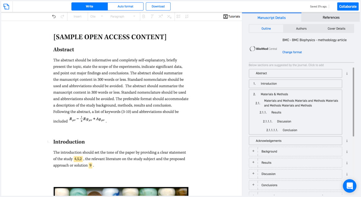
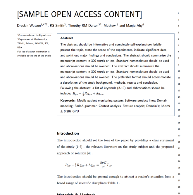
With SciSpace, you do not need a word template for Journal of Applied Remote Sensing.

It automatically formats your research paper to SPIE formatting guidelines and citation style.

You can download a submission ready research paper in pdf, LaTeX and docx formats.

Time comparison

Time taken to format a paper and Compliance with guidelines

Plagiarism Reports via Turnitin

SciSpace has partnered with Turnitin, the leading provider of Plagiarism Check software.

Using this service, researchers can compare submissions against more than 170 million scholarly articles, a database of 70+ billion current and archived web pages. How Turnitin Integration works?

Turnitin Stats
Publisher Logos

Freedom from formatting guidelines

One editor, 100K journal formats – world's largest collection of journal templates

With such a huge verified library, what you need is already there.

publisher-logos

Easy support from all your favorite tools

Journal of Applied Remote Sensing format uses spiebib citation style.

Automatically format and order your citations and bibliography in a click.

SciSpace allows imports from all reference managers like Mendeley, Zotero, Endnote, Google Scholar etc.

Frequently asked questions

1. Can I write Journal of Applied Remote Sensing in LaTeX?

Absolutely not! Our tool has been designed to help you focus on writing. You can write your entire paper as per the Journal of Applied Remote Sensing guidelines and auto format it.

2. Do you follow the Journal of Applied Remote Sensing guidelines?

Yes, the template is compliant with the Journal of Applied Remote Sensing guidelines. Our experts at SciSpace ensure that. If there are any changes to the journal's guidelines, we'll change our algorithm accordingly.

3. Can I cite my article in multiple styles in Journal of Applied Remote Sensing?

Of course! We support all the top citation styles, such as APA style, MLA style, Vancouver style, Harvard style, and Chicago style. For example, when you write your paper and hit autoformat, our system will automatically update your article as per the Journal of Applied Remote Sensing citation style.

4. Can I use the Journal of Applied Remote Sensing templates for free?

Sign up for our free trial, and you'll be able to use all our features for seven days. You'll see how helpful they are and how inexpensive they are compared to other options, Especially for Journal of Applied Remote Sensing.

5. Can I use a manuscript in Journal of Applied Remote Sensing that I have written in MS Word?

Yes. You can choose the right template, copy-paste the contents from the word document, and click on auto-format. Once you're done, you'll have a publish-ready paper Journal of Applied Remote Sensing that you can download at the end.

6. How long does it usually take you to format my papers in Journal of Applied Remote Sensing?

It only takes a matter of seconds to edit your manuscript. Besides that, our intuitive editor saves you from writing and formatting it in Journal of Applied Remote Sensing.

7. Where can I find the template for the Journal of Applied Remote Sensing?

It is possible to find the Word template for any journal on Google. However, why use a template when you can write your entire manuscript on SciSpace , auto format it as per Journal of Applied Remote Sensing's guidelines and download the same in Word, PDF and LaTeX formats? Give us a try!.

8. Can I reformat my paper to fit the Journal of Applied Remote Sensing's guidelines?

Of course! You can do this using our intuitive editor. It's very easy. If you need help, our support team is always ready to assist you.

9. Journal of Applied Remote Sensing an online tool or is there a desktop version?

SciSpace's Journal of Applied Remote Sensing is currently available as an online tool. We're developing a desktop version, too. You can request (or upvote) any features that you think would be helpful for you and other researchers in the "feature request" section of your account once you've signed up with us.

10. I cannot find my template in your gallery. Can you create it for me like Journal of Applied Remote Sensing?

Sure. You can request any template and we'll have it setup within a few days. You can find the request box in Journal Gallery on the right side bar under the heading, "Couldn't find the format you were looking for like Journal of Applied Remote Sensing?”

11. What is the output that I would get after using Journal of Applied Remote Sensing?

After writing your paper autoformatting in Journal of Applied Remote Sensing, you can download it in multiple formats, viz., PDF, Docx, and LaTeX.

12. Is Journal of Applied Remote Sensing's impact factor high enough that I should try publishing my article there?

To be honest, the answer is no. The impact factor is one of the many elements that determine the quality of a journal. Few of these factors include review board, rejection rates, frequency of inclusion in indexes, and Eigenfactor. You need to assess all these factors before you make your final call.

13. What is Sherpa RoMEO Archiving Policy for Journal of Applied Remote Sensing?

SHERPA/RoMEO Database

We extracted this data from Sherpa Romeo to help researchers understand the access level of this journal in accordance with the Sherpa Romeo Archiving Policy for Journal of Applied Remote Sensing. The table below indicates the level of access a journal has as per Sherpa Romeo's archiving policy.

RoMEO Colour Archiving policy
Green Can archive pre-print and post-print or publisher's version/PDF
Blue Can archive post-print (ie final draft post-refereeing) or publisher's version/PDF
Yellow Can archive pre-print (ie pre-refereeing)
White Archiving not formally supported
FYI:
  1. Pre-prints as being the version of the paper before peer review and
  2. Post-prints as being the version of the paper after peer-review, with revisions having been made.

14. What are the most common citation types In Journal of Applied Remote Sensing?

The 5 most common citation types in order of usage for Journal of Applied Remote Sensing are:.

S. No. Citation Style Type
1. Author Year
2. Numbered
3. Numbered (Superscripted)
4. Author Year (Cited Pages)
5. Footnote

15. How do I submit my article to the Journal of Applied Remote Sensing?

It is possible to find the Word template for any journal on Google. However, why use a template when you can write your entire manuscript on SciSpace , auto format it as per Journal of Applied Remote Sensing's guidelines and download the same in Word, PDF and LaTeX formats? Give us a try!.

16. Can I download Journal of Applied Remote Sensing in Endnote format?

Yes, SciSpace provides this functionality. After signing up, you would need to import your existing references from Word or Bib file to SciSpace. Then SciSpace would allow you to download your references in Journal of Applied Remote Sensing Endnote style according to Elsevier guidelines.

Fast and reliable,
built for complaince.

Instant formatting to 100% publisher guidelines on - SciSpace.

Available only on desktops 🖥

No word template required

Typset automatically formats your research paper to Journal of Applied Remote Sensing formatting guidelines and citation style.

Verifed journal formats

One editor, 100K journal formats.
With the largest collection of verified journal formats, what you need is already there.

Trusted by academicians

I spent hours with MS word for reformatting. It was frustrating - plain and simple. With SciSpace, I can draft my manuscripts and once it is finished I can just submit. In case, I have to submit to another journal it is really just a button click instead of an afternoon of reformatting.

Andreas Frutiger
Researcher & Ex MS Word user
Use this template