scispace - formally typeset
Search or ask a question
Journal ArticleDOI

A best practice framework to measure spatial variation in alcohol availability

01 Mar 2020-Vol. 47, Iss: 3, pp 381-399
TL;DR: A framework to help practitioners and researchers choose the most appropriate spatial method of measuring alcohol outlet density is presented, which includes components on theoretical geography, statistical implications and practical considerations, with an emphasis on population-level exposure.
Abstract: Alcohol outlet density and alcohol-related harms are an internationally reported phenomenon. There are multiple methods described in the literature to measure alcohol outlet density, but with very little commentary on the geographical underpinnings of the methods. In this paper, we present a framework to help practitioners and researchers choose the most appropriate spatial method of measuring alcohol outlet density. The framework includes components on theoretical geography, statistical implications and practical considerations, with an emphasis on population-level exposure. We describe the CHALICE alcohol outlet density measurement method that was developed to investigate the relationships between alcohol outlet density and population harm. The CHALICE method is compared to four other methods found in the published literature. We demonstrate the impact of methodological choices (e.g. network vs. Euclidean distances) on resulting alcohol outlet density scores. We conclude that wherever possible the best practice approach to modelling alcohol outlet density should be used to facilitate flexibility in subsequent statistical analysis and improve the transparency of the results.

Summary (3 min read)

The Framework

  • The framework is underpinned by three conceptual requirements: theoretical geographical underpinnings; statistical soundness; and practical implementation and interpretation.
  • The framework can be used to compare models of population-level exposure to alcohol outlets.

Theoretical geography components

  • Theoretical components comprise the core geographic principles underpinning AOD measurements.
  • Simply put, AOD is a measure of geographic access based on spatial location of alcohol outlets, typically around where people live.
  • It is underpinned by key theoretical principles of graph theory and topology (Curtin, 2007); population distribution modelling (Stewart and Warntz, 1958); and it informs spatial interaction modelling (Roy and Thill, 2003).
  • A cartographer understands scale as a ratio between the real world and a map representation, whereas to a GIS analyst scale may relate to spatial resolution or spatial extent of phenomena.
  • The larger the spatial unit of analysis the greater the potential for ecological fallacy (the extent to which assumptions about an individual may be incorrectly based on the group to which they belong - (Robinson, 1950).

Statistical components

  • The statistical component relates to how AOD is interpreted and used as part of a wider analysis.
  • The statistical component is inherently linked to the theoretical geography component described previously (robustness, sensitivity, ecological fallacy and MAUP).
  • As with all models, robust AOD measures should not be unduly affected by outliers, and have good performance when there are departures from the normal distribution (Huber and Ronchetti, 2009).
  • This can be tested by the size of the interquartile range and a comparison of the median values when comparing density scores produced by different methods.
  • The method should be sufficiently sensitive to measure AOD across all levels of geography as determined by the analysis plan.

Practical components

  • The final component of the framework considers the practicality of implementing and interpreting the results of an AOD measurement method.
  • Some methods reported in the literature only require standard spreadsheet software (e.g. outlets per population and outlets per km2) that are widely available and require no specialised training to use or implement.
  • The computational requirements to calculate an AOD are intrinsically linked to the size of the study area and number of observations, the scale at which the analysis is being performed (see the theoretical geography section) and the specialism.
  • An AOD measure that is difficult to interpret will make subsequent analysis difficult to design and implement and can impede the dissemination of findings to policy and practice.
  • The authors then illustrate the conceptual differences using three commonly used methods from the literature.

The CHALICE Methodology

  • The authors first compiled a dataset of alcohol outlets from Local Authority licensing records, described in detail elsewhere (Fone et al., 2016; Fry et al., 2016).
  • The authors calculated an AOD score for each household using a network dataset combining the Ordnance Survey (OS) Integrated Transport Network (ITN) and OS Urban Paths data (Ordnance Survey 2012).
  • The authors re-scaled the adjusted distances to give a value between 0 and 1 (1 high access, 0 poorer access) using a Butterworth filter gravity model (Langford et al., 2012), thus giving closer outlets a higher weighting than those further away from a residence.
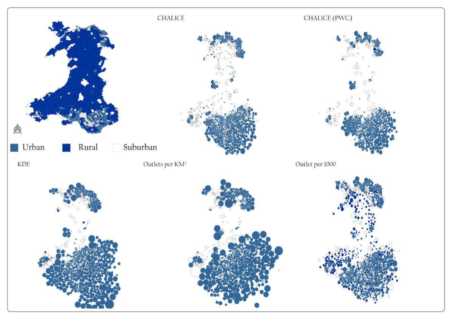
  • The authors mapped each method against the framework, derived descriptive statistics (counts of LSOAs with a score of zero AOD (#LSOAs -0), interquartile range (IQR), min, max, mean and median) for the five methods and plotted the density scores as Dorling pseudo-cartograms (Dorling, 1996) to visualise the differences.

AOD.

  • This introduces bias to the analysis, which is reflected in the theoretical scores and subsequent statistical scores.
  • The method is less computationally intensive and therefore scores higher than the household CHALICE method for practical components.
  • These limitations are also reflected in the statistical component scores and supported by the descriptive statistics (Table 2).
  • Interpretation of the KDE method is the most complex as the AOD at the measurement point is result of a distance weighted interpolation of distances to outlets over the study area.
  • The models of outlets per 1000 people and the outlets per km2 both have low theoretical scores due to the lack of inclusion of any theoretical geography beyond the grouping of outlets by small area geographies.

Statistical comparisons

  • Only the CHALICE method has a density score recorded for each of the 1896 LSOAs; there are no zero values (Table 2).
  • Stratification of the density measures by deprivation revealed that the most deprived areas of Wales had the biggest range of IQR values.
  • The differences increased as the density values increased (x-axis); differences between the measures became more scattered.
  • Inversely, Outlets per 1000 population produced higher values when compared to the CHALICE method resulting in a negative trend in the BA plots.
  • Repeating the BA analysis and stratifying the results by deprivation showed no systematic differences between the methods with large scatter of differences for density per 1000 population and the KDE methods compared with Outlets per km2.

Discussion

  • The method used to measure AOD is important because resultant statistical analysis on the associations between AOD and health is used to inform policy areas related to alcohol abuse.
  • From examining the raw outlet locations, the authors know that at least one household in each LSOA has access to at least one alcohol outlet within a 10-minute walk.
  • Particularly for smaller geographic units or at household level, these zeros should be evaluated in conjunction with the spatial distribution of the outlets to ensure that the zero is a true reflection of the spatial distribution of outlets and not a construct of the choice of method.
  • In comparison, methods that use network defined neighbourhoods and small base geographies to define localised AOD arguably better model spatial interactions between people and their surroundings and reduce the impacts of MAUP in subsequent analysis.

Conclusion

  • The use of the framework described in this paper will help researchers determine the best approach to measuring AOD and to understand the limitations of a chosen method whether it be theoretical, statistical or practical.
  • The framework will help improve the understanding of the relationship between AOD and alcohol use at the community level, particularly in rural areas, as identified by Bryden (2013).
  • Recent research on modelling the complexity of the relationships between environmental exposures and health has suggested that the most effective way of developing interventions at the population level is to target the modifiable aspects of the environment in which people reside (Brown et al., 2017) .
  • Moreover, the framework is not limited to AOD and could be applied to any scenario where measuring exposure to some socio-environmental phenomena is required (e.g. tobacco, fast food, urban green space).
  • Finally, but perhaps most importantly, understanding the bias and limitations of a method using the framework will also allow policy to more effectively implement licencing restrictions in relation to the oversupply of alcohol, an issue which is continually disputed by the alcohol industry as being a causal factor in public health (p17-18, The Scottish Parliament 2014).

Did you find this useful? Give us your feedback

Content maybe subject to copyright    Report

This is an Open Access document downloaded from ORCA, Cardiff University's institutional
repository: http://orca.cf.ac.uk/111024/
This is the author’s version of a work that was submitted to / accepted for publication.
Citation for final published version:
Fry, Richard, Orford, Scott, Rogers, Sarah, Morgan, Jennifer and Fone, David 2020. A best practice
framework to measure spatial variation in alcohol availability. Environment and Planning B: Urban
Analytics and City Science 47 (3) , pp. 381-399. 10.1177/2399808318773761 file
Publishers page: http://dx.doi.org/10.1177/2399808318773761
<http://dx.doi.org/10.1177/2399808318773761>
Please note:
Changes made as a result of publishing processes such as copy-editing, formatting and page
numbers may not be reflected in this version. For the definitive version of this publication, please
refer to the published source. You are advised to consult the publisher’s version if you wish to cite
this paper.
This version is being made available in accordance with publisher policies. See
http://orca.cf.ac.uk/policies.html for usage policies. Copyright and moral rights for publications
made available in ORCA are retained by the copyright holders.

A best practice framework to measure spatial variation in alcohol availability
1
This is a pre-copy-editing, author-produced PDF of an article accepted following peer review
for publication in Environment and Planning B: Urban Analytics and City Science
A best practice framework to measure spatial variation in alcohol availability
Fry, R.
1
, Orford, S.
2
, Rogers, S.
1
, Morgan, J.
2
, Fone, D.
2
1
Swansea University
2
Cardiff University
Abstract
Alcohol outlet density (AOD) and alcohol related harms are an internationally reported
phenomenon. There are multiple methods described in the literature to measure AOD, but
with very little commentary on the geographical underpinnings of the methods. In this paper,
we present a framework to help practitioners and researchers choose the most appropriate
spatial method of measuring AOD. The framework includes components on theoretical
geography, statistical implications and practical considerations, with an emphasis on
population level exposure. We describe the CHALICE AOD measurement method which
investigated the relationships between AOD and population harm (Fone et al. 2016). The
CHALICE method is compared to four other methods found in the published literature. We
demonstrate the impact of methodological choices (e.g. network vs. Euclidean distances) on
resulting AOD scores. We conclude that wherever possible the best practice approach to
modelling AOD should be used to facilitate flexibility in subsequent statistical analysis and
improve the transparency of the results.
Keywords
Alcohol Outlet Density; GIS; Framework; Alcohol Related Harm; Public Health

A best practice framework to measure spatial variation in alcohol availability
2
Introduction
The impact of alcohol outlet density (AOD) on health is an internationally reported
phenomenon with recent studies reporting on density measures from New Zealand (Cameron
et al., 2015), Australia (Livingston, 2014; Morrison et al., 2015), Scotland (Richardson et al.
2015), South Africa (Leslie et al., 2015) and the USA (Brenner et al., 2015; Cederbaum et al.,
2015; Cook et al., 2014; Parker, 2014). Their aims are to better understand the link between
AOD and the wide range of harms resulting from substantial levels of excess alcohol
consumption (Anderson, 2011; Campbell et al., 2009; World Health Organisation, 2017). As
the environment in which an individual resides has been demonstrated to be a key influencer
on individual behaviour in relation to alcohol use (Dahlgren and Whitehead, 2007), AOD
potentially impacts population health. Policy interventions which modify our environment to
reduce AOD by restricting the number of alcohol outlets in a geographic area requires robust
evidence to stand up to challenges from the retail sector and the multibillion pound alcohol
industry (e.g. The Scottish Parliament 2014).
Producing robust evidence linking AOD and health outcomes is not straight-forward, in part
because there is no agreed approach to measure AOD. Multiple approaches have been
reported in the literature (e.g. Fone et al., 2016; Grubesic et al., 2016; Richardson et al., 2015).
Two main issues can be identified here. The first is that any measure of AOD is based on
models, which are necessarily simplifications of reality. Good quality research should include
a statement of the limitations, or abstraction from reality but these statements are not always
evident, particularly with regard to the limitations of underlying AOD measurements. The
second is that alternative spatial models may produce different, and sometimes conflicting,
results and are often chosen in relation to the outcomes under investigation (e.g. alcohol

A best practice framework to measure spatial variation in alcohol availability
3
related harms, violence or consumption) making comparisons of outcome measures difficult
if not impossible. The limitations of AOD measurement methods need to be clearly
understood to facilitate statistical analysis and interpretation of results when analysing the
associations between AOD and outcomes.
In this paper, we present a best practice framework that will allow researchers and policy
makers to decide what makes a good spatial model of AOD given the circumstances or setting
of the research. Recent work by Grubesic et al. (2016) compares alcohol access in Seattle,
finding gravity model-based approaches to modelling access the most balanced approach.
We add to this work, through the development of a conceptual framework which can be used
to decide which AOD measurement is the most appropriate and to help researchers to define
the strengths and limitations of a method. We compare the different methods, like Grubesic
et al. (2016), but at a national population-level and add stratification by urban-rural
classifications and deprivation to investigate how the social and geographic morphologies
may influence AOD measurements. We illustrate the framework by comparing the main
measures of AOD reported in the literature to a high-resolution household level method
developed as part of the CHALICE project, which investigated the relationships between AOD
and population alcohol-related harm (Fone et al. 2016). We will focus on methods that
produce consistent and theoretically sound spatial models, which best capture the
environment in which an individual resides. Having a consistent spatial model is key to
understanding the other social processes influencing alcohol related health.

A best practice framework to measure spatial variation in alcohol availability
4
Alcohol outlet density in the literature
AOD measurements can be broadly split into population-based measures and geography-
based measures.. The main population-based measures are 1) counts of outlets per capita in
a population-based administrative unit (Gruenewald & Remer 2006; Treno et al. 2007;
Lapham et al. 2004; Cameron et al. 2015) and 2) counts of outlets per km
2
of a geographical
unit (Morrison et al. 2015; Yu et al. 2008; Pollack et al. 2005). These methods are less
concerned with local variation in AOD and more concerned with a per capita or per area unit
measure of AOD and assume a) that access is equal across a study area and b) the population
is unaffected by the constraints imposed by artificial boundaries (Richardson et al. 2015). The
most widely reported geography-based measures are 1) counts per walking or driving
eighourhood uffer zoe Hukle et al. 8; Pollak et al. 5) and 2) Kernel Density
Estimate measures (KDE), which model distance decay within user-defined neighbourhoods
(Richardson et al. 2015; Major et al. 2014; Berke et al. 2010). These methods measure AOD
(to varying degrees of sophistication), modelling spatial heterogeneity as a fundamental
component of the density measure. They typically use a Geographic Information System (GIS)
to define a local neighbourhood around a population centre either a household or a census
tract centroid. Other measures of alcohol outlet availability described in previous research
were calculated but are not presented here because they do not result in an area-based
density score; for instance, outlets per road distance (e.g. Yu et al. 2008; Yu et al. 2009; Cohen
et al. 2006) do not consider population distribution and assume equity of access across an
area. Nearest outlet to a home or population centre (Day et al., 2012; Halonen et al., 2013)
have also been excluded as they do not result in an outlet density measure. This literature

Citations
More filters
Journal ArticleDOI
20 Apr 2019-BMJ Open
TL;DR: This longitudinal, population-wide, record-linked natural experiment is to model the daily lived experience by linking GBS accessibility indices, residential GBS exposure and health data to enable quantification of the impact of GBS on well-being and common mental health disorders, for a national population.
Abstract: Introduction Studies suggest that access and exposure to green-blue spaces (GBS) have beneficial impacts on mental health. However, the evidence base is limited with respect to longitudinal studies. The main aim of this longitudinal, population-wide, record-linked natural experiment, is to model the daily lived experience by linking GBS accessibility indices, residential GBS exposure and health data; to enable quantification of the impact of GBS on well-being and common mental health disorders, for a national population. Methods and analysis This research will estimate the impact of neighbourhood GBS access, GBS exposure and visits to GBS on the risk of common mental health conditions and the opportunity for promoting subjective well-being (SWB); both key priorities for public health. We will use a Geographic Information System (GIS) to create quarterly household GBS accessibility indices and GBS exposure using digital map and satellite data for 1.4 million homes in Wales, UK (2008–2018). We will link the GBS accessibility indices and GBS exposures to individual-level mental health outcomes for 1.7 million people with general practitioner (GP) data and data from the National Survey for Wales (n=~12 000) on well-being in the Secure Anonymised Information Linkage (SAIL) Databank. We will examine if these associations are modified by multiple sociophysical variables, migration and socioeconomic disadvantage. Subgroup analyses will examine associations by different types of GBS. This longitudinal study will be augmented by cross-sectional research using survey data on self-reported visits to GBS and SWB. Ethics and dissemination All data will be anonymised and linked within the privacy protecting SAIL Databank. We will be using anonymised data and therefore we are exempt from National Research Ethics Committee (NREC). An Information Governance Review Panel (IGRP) application (Project ID: 0562) to link these data has been approved. The research programme will be undertaken in close collaboration with public/patient involvement groups. A multistrategy programme of dissemination is planned with the academic community, policy-makers, practitioners and the public.

13 citations


Cites methods from "A best practice framework to measur..."

  • ...We will adapt a previous methodology that modelled ‘change in alcohol outlet density and alcohol-related harm to population health’ (CHALICE).(60) The distance decay for this accessibility model will be updated to emulate how people engage with GBS as opposed to alcohol outlets....

    [...]

Journal ArticleDOI
TL;DR: Proximity, mean distance, and spatial access methods yielded the best model fits and had the lowest levels of error in this urban setting and may offer conceptual strengths over proximity and mean distance.
Abstract: Background The objective of this analysis was to compare measurement methods-counts, proximity, mean distance, and spatial access-of calculating alcohol outlet density and violent crime using data from Baltimore, Maryland. Methods Violent crime data (n = 11,815) were obtained from the Baltimore City Police Department and included homicides, aggravated assaults, rapes, and robberies in 2016. We calculated alcohol outlet density and violent crime at the census block (CB) level (n = 13,016). We then weighted these CB-level measures to the census tract level (n = 197) and conducted a series of regressions. Negative binomial regression was used for count outcomes and linear regression for proximity and spatial access outcomes. Choropleth maps, partial R2 , Akaike's Information Criterion, and root mean squared error guided determination of which models yielded lower error and better fit. Results The inference depended on the measurement methods used. Eight models that used a count of alcohol outlets and/or violent crimes failed to detect an association between outlets and crime, and 3 other count-based models detected an association in the opposite direction. Proximity, mean distance, and spatial access methods consistently detected an association between outlets and crime and produced comparable model fits. Conclusions Proximity, mean distance, and spatial access methods yielded the best model fits and had the lowest levels of error in this urban setting. Spatial access methods may offer conceptual strengths over proximity and mean distance. Conflicting findings in the field may be in part due to error in the way that researchers measure alcohol outlet density.

9 citations

Journal Article
TL;DR: Using path-integral techniques, Grégory Schehr and co-workers have calculated the exact distribution of the maximal height of vicious walker paths with and without a wall, or boundary, nearby and show an explicit connection to random matrix theory.
Abstract: Phys. Rev. Lett. 101, 150601 (2008) A random walk is a mathematical formalization of a path that consists of a succession of random steps. Among other things, it describes the trajectory taken by a molecule in a liquid or gas, or the path of an animal foraging for food. Vicious walks, however, are more constrained (and not as bad as they sound): different walkers’ paths are random but cannot cross. Grégory Schehr and co-workers have now established a physical connection between vicious walkers and random matrix theory. Using path-integral techniques, Schehr et al. have calculated the exact distribution of the maximal height of vicious walker paths (that is, a measure of the transverse fluctuations of the paths) with and without a wall, or boundary, nearby. Physically, the picture is akin to that of dislocations that arise at the transition between two states with latticebased magnetic or crystallographic structures. The results not only show an explicit connection to random matrix theory but also improve on previous numerical studies.

9 citations

01 Jan 2006
TL;DR: In this paper, the effect of neighborhood changes on gonorrhea rates was investigated and the authors found that after the 1992 civil unrest in Los Angeles, 270 alcohol outlets surrendered their licenses due to arson and vandalism thus providing a natural experiment.
Abstract: This study tests the effect of neighborhood changes on gonorrhea rates. Prior studies that indicate gonorrhea rates are associated with alcohol outlet density and neighborhood deterioration have been cross-sectional and cannot establish causality. After the 1992 Civil Unrest in Los Angeles, 270 alcohol outlets surrendered their licenses due to arson and vandalism thus providing a natural experiment. We geocoded all reported gonorrhea cases from 1988 to 1996 in LA County, all annually licensed alcohol outlets, and all properties damaged as a result of the civil unrest. We ran individual growth models to examine the independent effects of changes in alcohol outlets and damaged buildings on gonorrhea. The individual growth model explained over 90% of the residual variance in census tract gonorrhea rates. After the civil unrest, a unit decrease in the number of alcohol outlets per mile of roadway was associated with 21 fewer gonorrhea cases per 100,000 (p<.01) in tracts affected by the Unrest compared to those not affected. Neighborhood alcohol outlets appear to be significantly associated with changes in gonorrhea rates. The findings suggest that efforts to control sexually transmitted diseases, including gonorrhea and HIV, should address contextual factors that facilitate high-risk behaviors and disease transmission.

4 citations

References
More filters
Journal ArticleDOI
12 Nov 2015
TL;DR: The aim of this study was to quantify the error associated with different accessibility methods commonly used by public health researchers using geographical aggregated data in accessibility research, and to explain why contradicting results have been reported in the literature.
Abstract: The aim of this study was to quantify the error associated with different accessibility methods commonly used by public health researchers. Network distances were calculated from each household to the nearest GP our study area in the UK. Household level network distances were assigned as the gold standard and compared to alternate widely used accessibility methods. Four spatial aggregation units, two centroid types and two distance calculation methods represent commonly used accessibility calculation methods. Spearman's rank coefficients were calculated to show the extent which distance measurements were correlated with the gold standard. We assessed the proportion of households that were incorrectly assigned to GP for each method. The distance method, level of spatial aggregation and centroid type were compared between urban and rural regions. Urban distances were less varied from the gold standard, with smaller errors, compared to rural regions. For urban regions, Euclidean distances are significantly related to network distances. Network distances assigned a larger proportion of households to the correct GP compared to Euclidean distances, for both urban and rural morphologies. Our results, stratified by urban and rural populations, explain why contradicting results have been reported in the literature. The results we present are intended to be used aide-memoire by public health researchers using geographical aggregated data in accessibility research.

15 citations


"A best practice framework to measur..." refers background in this paper

  • ...Research has shown that omission of network routes can result in falsely assigning places as accessible (Apparicio and Seguin 2006; Higgs et al., 2012; Mizen et al., 2015)....

    [...]

  • ...…of a geographic network in analyses is an important component of measuring access to goods, services and places of interest as demonstrated by Apparicio et al. (2008), Higgs et al. (2012) and Mizen et al. (2015), which non-network approaches often resulting in significant variations in findings....

    [...]

Journal ArticleDOI
TL;DR: Neighborhood influence, beyond family qualities, is highlighted as a significant determinant of disadvantaged Black mothers' alcohol use and implications for public health policy are discussed.

13 citations


"A best practice framework to measur..." refers background in this paper

  • ...…with recent studies reporting on density measures from New Zealand (Cameron et al., 2015), Australia (Livingston, 2014; Morrison et al., 2015), Scotland (Richardson et al., 2015), South Africa (Leslie et al., 2015) and the USA (Brenner et al., 2015; Cederbaum et al., 2015; Cook et al., 2014)....

    [...]

Journal ArticleDOI
TL;DR: A gravity potential model provides a superior measure of alcohol access, and the alcohol access-based taxonomy a helpful evidence-based heuristic for scholars and local policymakers.
Abstract: A growing body of research recommends controlling alcohol availability to reduce harm. Various common approaches, however, provide dramatically different pictures of the physical availability of alcohol. This limits our understanding of the distribution of alcohol access, the causes and consequences of this distribution, and how best to reduce harm. The aim of this study is to introduce both a gravity potential measure of access to alcohol outlets, comparing its strengths and weaknesses to other popular approaches, and an empirically-derived taxonomy of neighborhoods based on the type of alcohol access they exhibit. We obtained geospatial data on Seattle, including the location of 2402 alcohol outlets, United States Census Bureau estimates on 567 block groups, and a comprehensive street network. We used exploratory spatial data analysis and employed a measure of inter-rater agreement to capture differences in our taxonomy of alcohol availability measures. Significant statistical and spatial variability exists between measures of alcohol access, and these differences have meaningful practical implications. In particular, standard measures of outlet density (e.g., spatial, per capita, roadway miles) can lead to biased estimates of physical availability that over-emphasize the influence of the control variables. Employing a gravity potential approach provides a more balanced, geographically-sensitive measure of access to alcohol outlets. Accurately measuring the physical availability of alcohol is critical for understanding the causes and consequences of its distribution and for developing effective evidence-based policy to manage the alcohol outlet licensing process. A gravity potential model provides a superior measure of alcohol access, and the alcohol access-based taxonomy a helpful evidence-based heuristic for scholars and local policymakers.

13 citations


"A best practice framework to measur..." refers background or methods or result in this paper

  • ...Multiple approaches have been reported in the literature (e.g. Fone et al., 2016; Grubesic et al., 2016; Richardson et al., 2015)....

    [...]

  • ...We compare the different methods, like Grubesic et al. (2016), but at a national population level and add stratification by urban–rural classifications and deprivation to investigate how the social and geographic morphologies may influence AOD measurements....

    [...]

  • ...This concurs with Grubesic et al. (2016) who found similar trends in Seattle....

    [...]

  • ...Recent work by Grubesic et al. (2016) compares alcohol access in Seattle, finding gravity model-based approaches to modelling access the most balanced approach....

    [...]

Journal Article
TL;DR: Using path-integral techniques, Grégory Schehr and co-workers have calculated the exact distribution of the maximal height of vicious walker paths with and without a wall, or boundary, nearby and show an explicit connection to random matrix theory.
Abstract: Phys. Rev. Lett. 101, 150601 (2008) A random walk is a mathematical formalization of a path that consists of a succession of random steps. Among other things, it describes the trajectory taken by a molecule in a liquid or gas, or the path of an animal foraging for food. Vicious walks, however, are more constrained (and not as bad as they sound): different walkers’ paths are random but cannot cross. Grégory Schehr and co-workers have now established a physical connection between vicious walkers and random matrix theory. Using path-integral techniques, Schehr et al. have calculated the exact distribution of the maximal height of vicious walker paths (that is, a measure of the transverse fluctuations of the paths) with and without a wall, or boundary, nearby. Physically, the picture is akin to that of dislocations that arise at the transition between two states with latticebased magnetic or crystallographic structures. The results not only show an explicit connection to random matrix theory but also improve on previous numerical studies.

9 citations


"A best practice framework to measur..." refers methods in this paper

  • ...The CHALICE method is not without limitations; the use of 10 minutes walking time to define a local neighbourhood is widely reported in the literature (Hewko et al., 2002; Langford et al., 2012; McGrail, 2012; Poelman, 2016)....

    [...]

  • ...This has been widely reported as a definition of a localised neighbourhood and used extensively in previous research (eg Jiao et al., 2011; Poelman, 2016; Reyes et al., 2014)....

    [...]

Journal Article
TL;DR: A brief summary of the research literature that links the local level density of alcohol outlets to alcohol-related problems is provided before focussing on the challenges of translating this epidemiological evidence into effective policy.
Abstract: This paper provides a brief summary of the research literature that links the local level density of alcohol outlets to alcohol-related problems before focussing on the challenges of translating this epidemiological evidence into effective policy. Alongside the ideological and political challenges of regulating the alcohol industry, there are two key issues that need to be tackled: critical weaknesses in the evidence base and the major challenges of policy implementation. These two areas are canvassed here, with implications for future research in this area and for the ongoing challenge of providing policy-relevant epidemiological evidence.

8 citations


Additional excerpts

  • ...The impact of alcohol outlet density (AOD) on health is an internationally reported phenomenon with recent studies reporting on density measures from New Zealand (Cameron et al., 2015), Australia (Livingston, 2014; Morrison et al., 2015), Scotland (Richardson et al., 2015), South Africa (Leslie et al., 2015) and the USA (Brenner et al., 2015; Cederbaum et al., 2015; Cook et al., 2014)....

    [...]

  • ..., 2015), Australia (Livingston, 2014; Morrison et al., 2015), Scotland (Richardson et al....

    [...]

  • ...…is an internationally reported phenomenon with recent studies reporting on density measures from New Zealand (Cameron et al., 2015), Australia (Livingston, 2014; Morrison et al., 2015), Scotland (Richardson et al., 2015), South Africa (Leslie et al., 2015) and the USA (Brenner et al., 2015;…...

    [...]

Frequently Asked Questions (2)
Q1. What are the contributions in this paper?

In this paper, the authors present a framework to help practitioners and researchers choose the most appropriate spatial method of measuring AOD. The authors describe the CHALICE AOD measurement method which investigated the relationships between AOD and population harm ( Fone et al. 2016 ). The authors demonstrate the impact of methodological choices ( e. g. network vs. Euclidean distances ) on resulting AOD scores. The authors conclude that wherever possible the best practice approach to modelling AOD should be used to facilitate flexibility in subsequent statistical analysis and improve the transparency of the results. 

The interactions between multi-scale AOD and health and social outcomes are an important area for future work. For example, in one of the LSOAs with a zero value there are 16 outlets within the LSOA ( but beyond 10 minutes walk of the PWC ), and a further 6 outlets in an adjacent LSOA but close enough to the boundary to be accessible. However, the authors further demonstrate that this problem is exacerbated when the results are examined over a whole country with stratification by rural-urban classification revealing over and under inflation of AOD.