scispace - formally typeset
Search or ask a question
Journal ArticleDOI

A constrained A* approach towards optimal path planning for an unmanned surface vehicle in a maritime environment containing dynamic obstacles and ocean currents

Yogang Singh1, Sanjay Sharma1, Robert Sutton1, DC Hatton1, Asiya Khan1 
01 Dec 2018-Ocean Engineering (Elsevier)-Vol. 169, pp 187-201
TL;DR: Even after embargo period expires, authors' right to distribute as green open access is conditional on the green openAccess version including a DOI link, and on thegreen open access version being distributed under the Creative Commons CC-BY-NC-ND licence.
About: This article is published in Ocean Engineering.The article was published on 2018-12-01 and is currently open access. It has received 169 citations till now.

Summary (5 min read)

1. Introduction

  • Recent advances in electronic navigation and intelligent robots have become an imperative aid to navigate marine vehicles effectively for applications ranging from reconnaissance in hostile areas to operations in dangerous weather conditions (Loe, 2008).
  • Ocean environmental effects and moving obstacles play the most significant role in path planning of USVs and very few literatures have covered their effect on path planning in the last decade (Tam et al., 2009, Statheros et al., 2008).
  • In the subsequent section, simulation studies conducted in various environmental scenarios are reported and the proposed approach is benchmarked.
  • The conclusions of the current study are reported in the final section.

1.2. Problem definition and major contribution

  • In the present context of autonomy required in the marine environment, autonomous navigation of USVs in a practical marine environment needs to be cognizable of three important issues, namely, safety, reliability of the mission and likelihood of the success (Statheros et al., 2008, LaValle, 2006).
  • Central to the path planning algorithms, two approaches are widely adopted namely, a waypoint approach and a trajectory based approach.
  • Hence there is a challenge to conserve energy as well as consider safety of USVs in USV path planning for USVs designed with heterogeneous mission requirements in mind.
  • Ocean environmental effects can be bifurcated into three streams, as the additive and multiplicative disturbances on vehicle hull, namely, wind, waves and ocean currents (Fossen, 1995).
  • Another major challenge is to understand the steady non uniform headwind and tailwind (Knight, 2008, Belcher, 2007) currents effect on way-point generation and optimality in grid-based path planners.

2.1. Environmental mapping

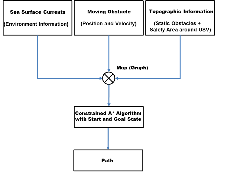
  • The abstraction of path planning for USVs is shown in Fig.3.
  • In order to implement path planning algorithms, mapping the environment becomes the initial step.
  • Environmental mapping converts world space into Configuration space which helps in quick implementation of algorithms and manageable storage in computers (Mooney et al., 2010).
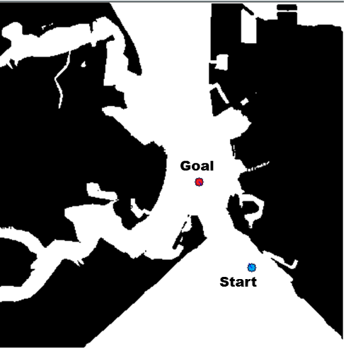
  • Portsmouth harbour is among the busiest harbours in United Kingdom and is a perfect area for understanding path planning of USVs.

2.2. A* Algorithm

  • In the present study, the A* approach with safety distance constraints has been adopted.
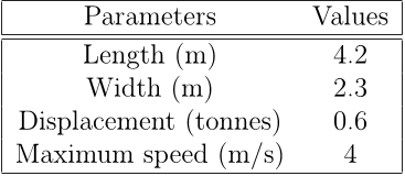
  • Since the current study considers an USV, Springer, developed with primary purpose of monitoring sea pollution, generation of safer way points with conservation of optimality for higher endurance becomes the highest priority.
  • No approach has been able to compute path with a better computational time than the conventional A* approach in simulation studies.
  • Each adjacent cell of actually reached cell is evaluated by value of f(n) and the one with lowest value of f(n) is chosen as the next one in sequence.
  • This advantage of modifying distance in A* gives wide range of modifications which can be applied in the algorithm in form of energy consumption and safety distance (Duchoň et al., 2014).

2.3. Assumptions

  • The complexity of USV path planning is massive and a number of simplifications have been recommended to reduce the intricacies of the problem (Azariadis and Aspragathos, 2005).
  • Here, the following assumptions have been made: 1. The map (study area) is considered to be in a confined sea environment near to Portsmouth harbor.
  • Kalman filter and other sensor measurements are used on a USV to determine the obstacle position over time.
  • Overlapping of elliptical shape with grid cell boundary is neglected.
  • The deliberative systems help in determining global waypoints while reactive systems are responsible for collision avoidance when dynamic obstacles come in the USV safety domain described in Fig.

2.4. Challenges of incorporating COLREGs in path planning algorithms

  • The COLREGs serves as a handbook for selecting avoidance manoeuvres.
  • Recently, several efforts have been made to integrate COLREGs in path planning algorithms for USVs (Svec et al., 2013, Kuwata et al., 2014).
  • These studies work safely in a scenario with very few complexities with an assumption that each vessel in the operational domain has the same amount of information about the current COLREGs situation and reacts in same way.
  • This hypothesis does not hold true in real time where each sailor interprets COLREGs based on speed, size and heading of the other vessel (Shah, 2016).
  • In addition to that, various external factors such as limited field of view, ocean currents and seamanship in case of breaching the COLREGs make it non-trivial to incorporate COLREGs rules into path planning framework used in complex scenarios.

2.5. Incorporating Guidance and Control System with Path Planning Algorithm

  • The general architecture of an USV operation in a maritime environment has basically three subsystems, namely, control and path planning, obstacle detection and avoidance (ODA) and communication and monitoring as shown in Fig.6.
  • The current study proposes an computationally effective and safer approach for generation of optimal waypoints for USV navigation in the desired environment.
  • Guidance is responsible to achieve motion control objectives in the physical environment in which the vehicle moves (Bibuli et al., 2009).
  • The easiest way is to use a classical autopilot system, so that commanded yaw angle generated from a line-of-sight (LOS) guidance algorithm can be controlled (assuming sufficient bandwidth) and cross track error is minimized.
  • In terms of autopilot and control system development, a detailed review of studies con- ducted on USVs has been discussed by Roberts (2008).

2.6. Collision avoidance in close encounter situation

  • The general architecture for a USV operation in a maritime environment described in Fig.6 shows that high level planners send waypoints to low level decision makers i.e. local control systems and obstacle avoidance subsystems to execute the waypoint following task.
  • When a time variant moving obstacle enters the working domain of the operating USV, it is expected that high level planners quickly regenerates new set of way points based on the current information of the environment.
  • Many other factors like relative velocity of the USV and the obstacle , the sensing horizon etc also plays an important role in such regeneration process.
  • In such transition, it is hereby required to have a quick response time from the high level planners which is one of the main objectives of the current study.
  • To enable the safe and secure operation of autonomous surface ships within the existing IMO requirement, a code of practice has been prepared by the UK Maritime Autonomous Systems Working Group and published by Maritime UK through the Society of Maritime Industries (UK, 2017).

3. Simulation Results

  • The proposed approach is simulated using C++ and OpenCV.
  • The simulations were repeated for 500 times, especially in terms of computational time, to account for variable computational power in OS Windows.
  • The average time from all repetitions was calculated for proper verification of the proposed approach.

3.1. Comparing A* approach with and without safety distance

  • The proposed study deals with inclusion of a safety distance criteria in the A* approach towards USV path planning.
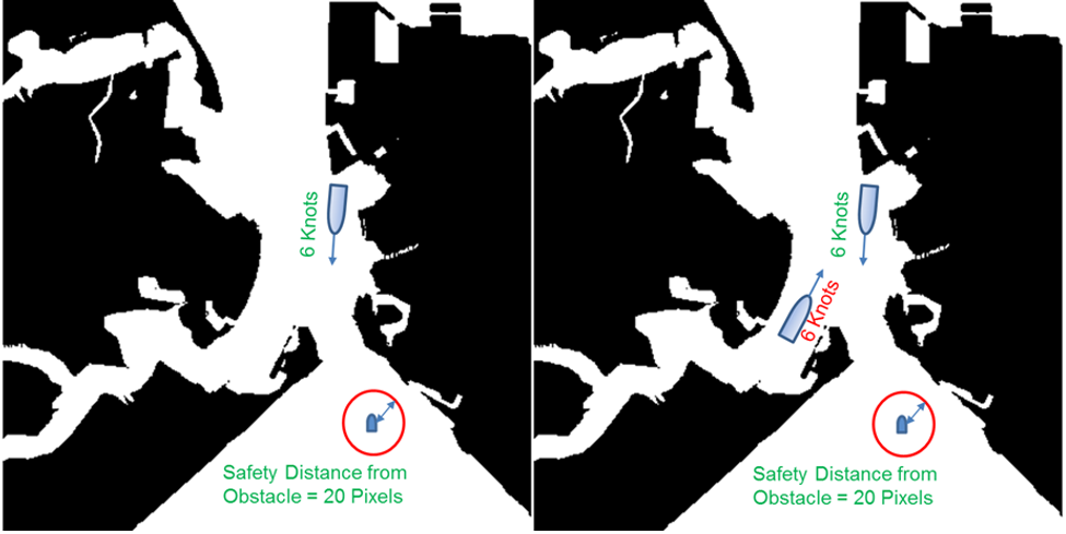
  • In order to benchmark the safety distance approach and to decide upon an optimum value of safety distance, four arbitrary values, 10, 20, 30 and 40 pixels are taken as safety distance on a grid map (as shown in Fig. 2) and compared against an A* approach without safety distance in terms of computational time.
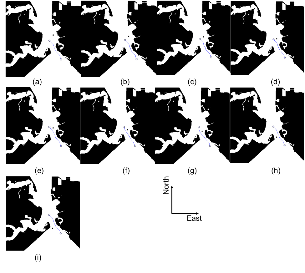
  • In terms of path length, simulations shows that the A* approach with and without safety distance constraint produces path of equal length i.e. 1.043 km although a difference in resultant path can be seen in Fig.11.
  • This leads to the fact that optimality remains conserved in path planning with decrease in computational effort in the proposed approach unlike ones adopted in literature towards path planning of USVs where an increase in computational cost has been observed with increase in path length for proposed approaches.
  • This value also provides enough time for local reactive techniques for collision avoidance in case where one or more moving obstacles are detected in the operational domain of the USV.

3.2. Constrained A* approach under static and partially dynamic environment

  • In order to understand the effectiveness of the proposed approach, simulations are conducted in binary maps of Portsmouth harbour comprising of static obstacles as well as moving obstacles.
  • The computational time again increases once the moving obstacle escapes out of the safety domain of the USV.
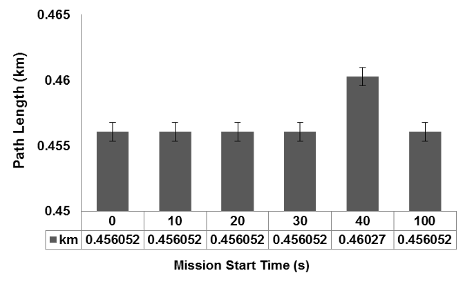
  • The results shown in Fig.18 shows path generated by proposed approach in different scenarios of an maritime environment with two moving obstacles.
  • In this case also the same pattern as found with the single moving obstacle scenario is observed.
  • The comparison of path length and computational time is shown in Fig.19 and Fig.20 respectively.

3.3. Constrained A* approach with environmental disturbances

  • Ocean currents generated in the upper layer of the ocean environment by atmospheric wind system are referred as sea surface currents (Fossen, 1995).
  • Real ocean currents are multi-directional and irregular, spatially and temporally.
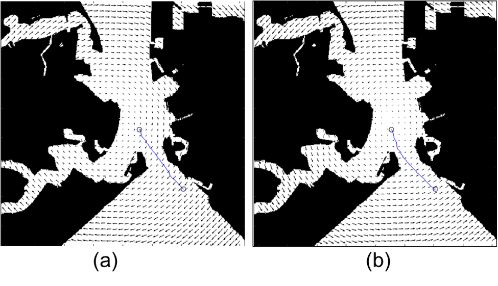
  • Path length and computational time are compared for both scenarios shown in Fig.21 and results are presented in Fig.22 and Fig.23 respectively.
  • Along the same line, currents of 2.5 m/s are considered to understand the path planning pattern of USV under influence of strong ocean currents.
  • Fig.24 shows the path obtained by the proposed approach with currents moving in anti-clockwise and clockwise direction with intensity of 2.5 m/s.

3.4. Constrained A* approach with single moving obstacle and environmental disturbance

  • Since the complexity of the environment has increased, a more flexible safety distance constraint of 15 pixel has been adopted for this study in order to keep a proper trade off between optimal way points and environmental complexity.
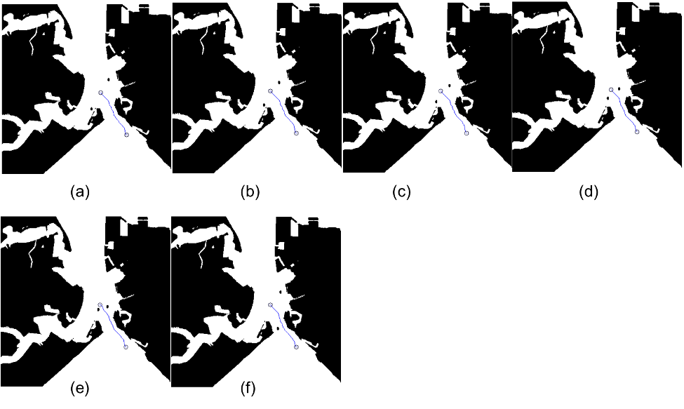
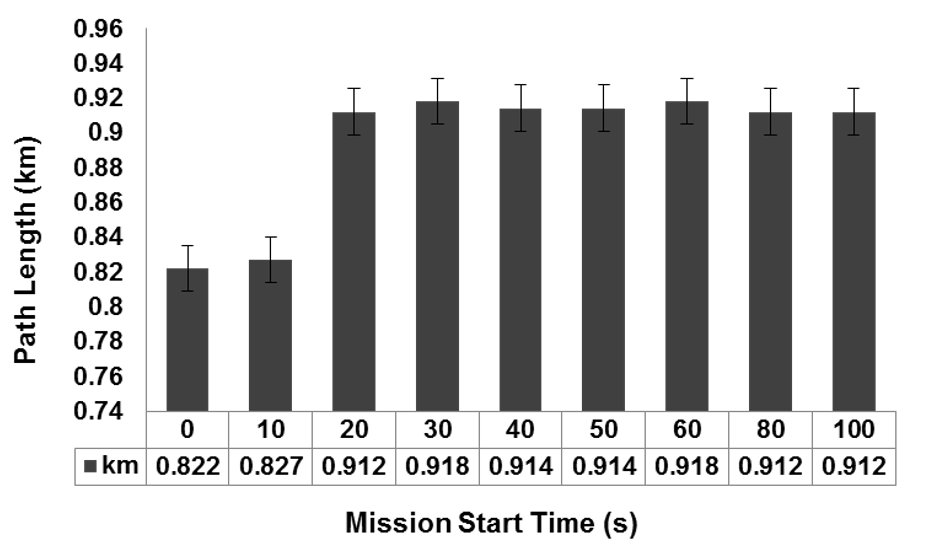
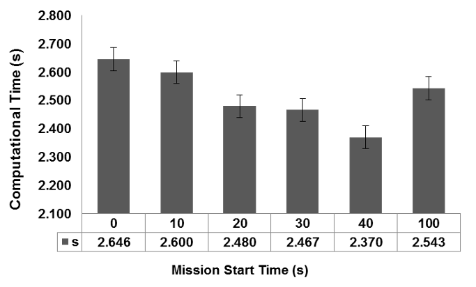
  • Fig.28 shows the generated paths for different start time in the environment comprising of static obstacle, sea surface currents of 1.4 m/s moving in anticlockwise direction and moving obstacle (where each dynamic position is considered static).
  • Comparison of path length and computational time for all scenarios presented in Fig.28 are shown in Fig.27 and Fig.29 respectively.
  • In addition to that, most cases have been able to generate path within a reasonable computational time.
  • These results show that the proposed algorithm can generate safer way points for the USV voyage for long and short duration missions in a cluttered complex environment.

4. Conclusions

  • The objective of generating safer way points by keeping a safe distance from the obstacle was evaluated in simulations, conducted in various environments comprising of static obstacle, moving obstacle and sea surface currents of different intensities.
  • The upstream and effects of sea surface currents was evaluated and effect of sea surface currents with moving obstacle was also analysed.
  • The simulation results shows that the present approach generates safer way points for USV voyage in a computationally efficient manner against the conventional A* approach with no loss of optimality.
  • Another extension of the present work lies in considering heading angle constraint for USV, in such cases, where, path length is more important than computational time.
  • Most leading companies in USV operations are looking for the integration of COLREGs with optimal path planners to abide the working guidelines of the IMO.

Did you find this useful? Give us your feedback

Figures (30)
Citations
More filters
Journal ArticleDOI
TL;DR: In this paper, a water depth risk level A* algorithm (WDRLA*) is proposed to plan the path, which takes hydrodynamic characteristics and navigation errors into account.
Abstract: The depth of water is of great significance to the safe navigation of unmanned surface vehicles (USV)in shallow waters, such as islands and reefs. How to consider the influence of depth on the safety of USV navigation and path planning is relatively rare. Under the condition of ocean disturbance, the hydrodynamic characteristics of unmanned surface vehicles will affect its draft and depth safety. In this paper, the hydrodynamic model of unmanned surface vehicles is analyzed, and a water depth risk level A* algorithm (WDRLA*) is proposed. According to the depth point of the electronic navigation chart (ENC), the gridding depth can be obtained by spline function interpolation. The WDRLA* algorithm is applied to plan the path, which takes hydrodynamic characteristics and navigation errors into account. It is compared with the traditional A* shortest path and safest path. The simulation results show that the WDRLA* algorithm can reduce the depth hazard of the shortest path and ensure the safety of navigation.

14 citations

Journal ArticleDOI
TL;DR: Wang et al. as mentioned in this paper proposed a multi-ship automatic collision avoidance method based on a double deep Q network (DDQN) with prioritized experience replay, which greatly reduces the number of state transitions in the Markov decision process (MDP).
Abstract: Ship collisions often result in huge losses of life, cargo and ships, as well as serious pollution of the water environment. Meanwhile, it is estimated that between 75% and 86% of maritime accidents are related to human factors. Thus, it is necessary to enhance the intelligence of ships to partially or fully replace the traditional piloting mode and eventually achieve autonomous collision avoidance to reduce the influence of human factors. In this paper, we propose a multi-ship automatic collision avoidance method based on a double deep Q network (DDQN) with prioritized experience replay. Firstly, we vectorize the predicted hazardous areas as the observation states of the agent so that similar ship encounter scenarios can be clustered and the input dimension of the neural network can be fixed. The reward function is designed based on the International Regulations for Preventing Collision at Sea (COLREGs) and human experience. Different from the architecture of previous collision avoidance methods based on deep reinforcement learning (DRL), in this paper, the interaction between the agent and the environment occurs only in the collision avoidance decision-making phase, which greatly reduces the number of state transitions in the Markov decision process (MDP). The prioritized experience replay method is also used to make the model converge more quickly. Finally, 19 single-vessel collision avoidance scenarios were constructed based on the encounter situations classified by the COLREGs, which were arranged and combined as the training set for the agent. The effectiveness of the proposed method in close-quarters situation was verified using the Imazu problem. The simulation results show that the method can achieve multi-ship collision avoidance in crowded waters, and the decisions generated by this method conform to the COLREGs and are close to the level of human ship handling.

14 citations

Journal ArticleDOI
TL;DR: In this article, a hybrid approach for path planning of autonomous ships that generates both global and local paths, respectively, is proposed, where the global path is obtained via an improved artificial potential field (APF) method, which makes up for the shortcoming that the typical APF method easily falls into a local minimum.
Abstract: In this research, a hybrid approach for path planning of autonomous ships that generates both global and local paths, respectively, is proposed. The global path is obtained via an improved artificial potential field (APF) method, which makes up for the shortcoming that the typical APF method easily falls into a local minimum. A modified velocity obstacle (VO) method that incorpo-rates the closest point of approach (CPA) model and the International Regulations for Preventing Collisions at Sea (COLREGS), based on the typical VO method, can be used to get the local path. The contribution of this research is two-fold: (1) improvement of the typical APF and VO methods, making up for previous shortcomings, and integrated COLREGS rules and good seamanship, making the paths obtained more in line with navigation practice; (2) the research included global and local path planning, considering both the safety and maneuverability of the ship in the process of avoiding collision, and studied the whole process of avoiding collision in a relatively entirely way. A case study was then conducted to test the proposed approach in different situations. The results indicate that the proposed approach can find both global and local paths to avoid the target ship.

11 citations

Journal ArticleDOI
TL;DR: In this paper, a collision avoidance algorithm for UAVs in the scenario of multi-vessel encounters is proposed, which is composed of two parts: a collision detection model and a path re-planning algorithm.
Abstract: Focusing on the collision avoidance problem for Unmanned Surface Vehicles (USVs) in the scenario of multi-vessel encounters, a USV autonomous obstacle avoidance algorithm based on the improved velocity obstacle method is proposed. The algorithm is composed of two parts: a multi-vessel encounter collision detection model and a path re-planning algorithm. The multi-vessel encounter collision detection model draws on the idea of the velocity obstacle method through the integration of characteristics such as the USV dynamic model in the marine environment, the encountering vessel motion model, and the International Regulations for Preventing Collisions at Sea (COLREGS) to obtain the velocity obstacle region in the scenario of USV and multi-vessel encounters. On this basis, two constraint conditions for the motion state space of USV obstacle avoidance behavior and the velocity obstacle region are added to the dynamic window algorithm to complete a USV collision risk assessment and generate a collision avoidance strategy set. The path re-planning algorithm is based on the premise of the minimum resource cost and uses an improved particle swarm algorithm to obtain the optimal USV control strategy in the collision avoidance strategy set and complete USV path re-planning. Simulation results show that the algorithm can enable USVs to safely evade multiple short-range dynamic targets under COLREGS.

11 citations

Journal ArticleDOI
19 Nov 2021-Symmetry
TL;DR: The EBHSA* algorithm as mentioned in this paper introduces the expansion distance, bidirectional search, heuristic function optimization and smoothing into path planning, which extends a certain distance from obstacles to improve path robustness by avoiding collisions.
Abstract: Path planning plays an essential role in mobile robot navigation, and the A* algorithm is one of the best-known path planning algorithms. However, the conventional A* algorithm and the subsequent improved algorithms still have some limitations in terms of robustness and efficiency. These limitations include slow algorithm efficiency, weak robustness, and collisions when robots are traversing. In this paper, we propose an improved A*-based algorithm called EBHSA* algorithm. The EBHSA* algorithm introduces the expansion distance, bidirectional search, heuristic function optimization and smoothing into path planning. The expansion distance extends a certain distance from obstacles to improve path robustness by avoiding collisions. Bidirectional search is a strategy that searches for a path from the start node and from the goal node at the same time. Heuristic function optimization designs a new heuristic function to replace the traditional heuristic function. Smoothing improves path robustness by reducing the number of right-angle turns. Moreover, we carry out simulation tests with the EBHSA* algorithm, and the test results show that the EBHSA* algorithm has excellent performance in terms of robustness and efficiency. In addition, we transplant the EBHSA* algorithm to a robot to verify its effectiveness in the real world.

11 citations

References
More filters
Book
01 Jan 2002

17,039 citations

Journal ArticleDOI
TL;DR: How heuristic information from the problem domain can be incorporated into a formal mathematical theory of graph searching is described and an optimality property of a class of search strategies is demonstrated.
Abstract: Although the problem of determining the minimum cost path through a graph arises naturally in a number of interesting applications, there has been no underlying theory to guide the development of efficient search procedures. Moreover, there is no adequate conceptual framework within which the various ad hoc search strategies proposed to date can be compared. This paper describes how heuristic information from the problem domain can be incorporated into a formal mathematical theory of graph searching and demonstrates an optimality property of a class of search strategies.

10,366 citations

01 Jan 2010

6,571 citations

Journal ArticleDOI
TL;DR: This paper reformulated the manipulator con trol problem as direct control of manipulator motion in operational space—the space in which the task is originally described—rather than as control of the task's corresponding joint space motion obtained only after geometric and geometric transformation.
Abstract: This paper presents a unique real-time obstacle avoidance approach for manipulators and mobile robots based on the artificial potential field concept. Collision avoidance, tradi tionally considered a high level planning problem, can be effectively distributed between different levels of control, al lowing real-time robot operations in a complex environment. This method has been extended to moving obstacles by using a time-varying artificial patential field. We have applied this obstacle avoidance scheme to robot arm mechanisms and have used a new approach to the general problem of real-time manipulator control. We reformulated the manipulator con trol problem as direct control of manipulator motion in oper ational space—the space in which the task is originally described—rather than as control of the task's corresponding joint space motion obtained only after geometric and kine matic transformation. Outside the obstacles' regions of influ ence, we caused the end effector to move in a straight line with an...

6,515 citations


"A constrained A* approach towards o..." refers background in this paper

  • ...Path planning for USVs can be classified into two categories, namely, reactive approaches (Khatib, 1986, Borenstein and Koren, 1991, Mohanty and Parhi, 2013, Fiorini and Shiller, 1998) where vehicles makes decision en route and deliberative approaches where vehicles follows a predetermined path…...

    [...]

MonographDOI
01 Jan 2006
TL;DR: This coherent and comprehensive book unifies material from several sources, including robotics, control theory, artificial intelligence, and algorithms, into planning under differential constraints that arise when automating the motions of virtually any mechanical system.
Abstract: Planning algorithms are impacting technical disciplines and industries around the world, including robotics, computer-aided design, manufacturing, computer graphics, aerospace applications, drug design, and protein folding. This coherent and comprehensive book unifies material from several sources, including robotics, control theory, artificial intelligence, and algorithms. The treatment is centered on robot motion planning but integrates material on planning in discrete spaces. A major part of the book is devoted to planning under uncertainty, including decision theory, Markov decision processes, and information spaces, which are the “configuration spaces” of all sensor-based planning problems. The last part of the book delves into planning under differential constraints that arise when automating the motions of virtually any mechanical system. Developed from courses taught by the author, the book is intended for students, engineers, and researchers in robotics, artificial intelligence, and control theory as well as computer graphics, algorithms, and computational biology.

6,340 citations


"A constrained A* approach towards o..." refers background in this paper

  • ...In the present context of autonomy required in the marine environment, autonomous navigation of USVs in a practical marine environment needs to be cognizable of three important issues, namely, safety, reliability of the mission and likelihood of the success (Statheros et al., 2008, LaValle, 2006)....

    [...]

Frequently Asked Questions (2)
Q1. What are the contributions in "A constrained a* approach towards optimal path planning for an unmanned surface vehicle in a maritime environment containing dynamic obstacles and ocean currents" ?

Unlike existing work on USV navigation using graph based methods, this study extends the implementation of the proposed A * approach in an environment cluttered with static and moving obstacles and different current intensities. The study also examines the effect of headwind and tailwind currents moving in clockwise and anti clockwise direction respectively of different intensities on optimal waypoints in a partially dynamic environment. 

The approach is found to be robust, computationally efficient and can be extended for real time path planning of USVs in confined water. In future work, it is planned to extend the work in development of a path follower approach working in conjugation with proposed approach for a reactive path planning in scenarios involving close encounters. A challenging 28 extension of the current work lies in fact of finding a heuristic cost function which can take into account rules of the COLREGs without compromising the optimality and computational effort required to find a feasible trajectory.