scispace - formally typeset
Search or ask a question
Proceedings ArticleDOI

A genetic algorithm for simultaneous localization and mapping

Tom Duckett1
10 Nov 2003-Vol. 1, pp 434-439
TL;DR: A genetic algorithm is described for solving the problem of simultaneous localization and mapping by a mobile robot, in which a population of candidate solutions is progressively refined in order to find a globally optimal solution.
Abstract: This paper addresses the problem of simultaneous localization and mapping (SLAM) by a mobile robot. The SLAM problem is defined as a global optimization problem in which the objective is to search the space of possible robot maps. A genetic algorithm is described for solving this problem, in which a population of candidate solutions is progressively refined in order to find a globally optimal solution. The fitness values in the genetic algorithm are obtained with a heuristic function that measures the consistency and compactness of the candidate maps. The results show that the maps obtained are very accurate, though the approach is computationally expensive. Directions for future research are also discussed.

Summary (2 min read)

I. INTRODUCTION

  • Maps are very useful for navigation by mobile robots in complex environments, being needed for tasks such as self-localization, path planning, manipulation of objects, and interaction with humans.
  • Without this assumption, the robot must somehow search the space of possible maps, since alternative assignments in data association can induce very different maps.
  • Each of these trajectories is then evaluated by constructing a global occupancy map using the recorded range-finder data of the robot along the travelled path.
  • A fitness value is calculated for each of the candidate solutions, based on the consistency and compactness of the maps produced, and the search proceeds using a genetic algorithm (GA).

III. SLAM AS A GLOBAL OPTIMIZATION PROBLEM

  • In a global optimization problem, there may be many solutions which are locally optimal.
  • The goal is to find the one best solution, avoiding the local optima [15] .
  • A global search algorithm can be used to search the space of possible trajectories.
  • The goal is to find the vector of noise parameters, and therefore the inferred trajectory, which produces the best map.
  • Each iteration or "generation" involves a competitive selection procedure that favours fitter solutions and rejects poorer solutions.

A. Chromosome Encoding

  • Each chromosome is encoded as a string of floating point numbers corresponding to the correction factors applied to the recorded odometry data.
  • In the experiments presented here, the odometer trace was divided into segments of 3 meters in length.
  • That is, the measured values of δ j and α j obtained from the robot's odometry are assumed to lie within a fixed range of their true values (in the experiments presented here, a range of ±2% was assumed for both the distances and angles).
  • It would also be possible to assume some parametric distribution (e.g., Gaussian) for the correction factors during initialization.

B. Fitness Function

  • The fitness function contains domain specific knowledge that is used to assess the quality of the candidate solutions.
  • A much simplified version of the occupancy grid model [12] is used to construct a map for each candidate solution, then two heuristics are combined to obtain a fitness value for each map.
  • The recorded odometry data is corrected using the correction factors encoded in the chromosome.
  • The following heuristic functions are then calculated:.

1) Map Consistency (MC1):

  • The idea here is to measure the overall consistency of the sensory information contained in the gridmap.
  • The authors try to measure the degree of disagreement or "conflict" between the sensor readings.
  • A similar metric was proposed by Murphy et al. [13] based on Dempster-Shafer theory.

2) Map Compactness (MC2):

  • Early experiments with the map consistency measure showed that the genetic algorithm could produce maps with very low conflict but which were obviously incorrect to the human eye.
  • The GA would try to avoid conflictrather than resolving it -by "twisting" certain critical areas of the map away from one another, when the represented regions were in fact physically adjacent (see Fig. 2 ).
  • The idea here is to reward the GA for producing smaller, more compact maps.
  • Note that better maps produce lower values of F.

C. Selection, Crossover and Mutation

  • The selection phase in a genetic algorithm involves creating a "mating pool" by picking individual solutions that are fitter with higher probability.
  • Individuals are then assigned an offspring count that is solely a function of their rank, using the scheme proposed by Baker [1] .
  • Instead, a scheme known as Remainder Stochastic Sampling Without Replacement is used.
  • The remaining strings needed to fill out the population are then obtained randomly by generating new offspring for each string with probability equal to the fractional part of e l .
  • Pairs of selected strings are then combined by crossover.

V. EXPERIMENTAL RESULTS

  • The algorithm was first tested using data recorded by a Pioneer I mobile robot equipped with a SICK laser scanner at the Artificial Intelligence Lab of the University of Freiburg [6] .
  • The genetic algorithm was run for 150 generations with a population size of 50, i.e., a total of 7500 candidate maps were evaluated, taking around 2 hours on a 200MHz Pentium II processor.
  • Fig. 4 shows the resulting fitness values produced, illustrating the convergence of the algorithm over time.
  • The corrected sensor data obtained from the fittest solution, together with the corresponding gridmap, is shown in Fig. 3 .

Did you find this useful? Give us your feedback

Content maybe subject to copyright    Report

A Genetic Algorithm for Simultaneous Localization and Mapping
Tom Duckett
Centre for Applied Autonomous Sensor Systems
Dept. of Technology,
¨
Orebro University
SE-70182
¨
Orebro, Sweden
http://www.aass.oru.se
AbstractThis paper addresses the problem of
simultaneous localization and mapping (SLAM) by
a mobile robot. The SLAM problem is defined as a
global optimization problem in which the objective is
to search the space of possible robot maps. A genetic al-
gorithm is described for solving this problem, in which
a population of candidate solutions is progressively
refined in order to find a globally optimal solution.
The fitness values in the genetic algorithm are obtained
with a heuristic function that measures the consistency
and compactness of the candidate maps. The results
show that the maps obtained are very accurate, though
the approach is computationally expensive. Directions
for future research are also discussed.
I. INTRODUCTION
Maps are very useful for navigation by mobile
robots in complex environments, being needed for
tasks such as self-localization, path planning, manip-
ulation of objects, and interaction with humans. To
navigate in unknown environments, an autonomous
robot requires the ability to build its own map while
simultaneously maintaining an estimate of its own
position. This is a hard problem because the same,
noisy sensor data must be used for both mapping and
localization. We can separate two major sources of
uncertainty in solving this problem:
(i.) the continuous uncertainty in the positions of the
vehicle and the observed environmental features
(e.g., due to sensor noise, uncertain execution of
motor commands, etc.), and
(ii.) the combinatorial labelling problem of data as-
sociation (e.g., landmark identification, feature
recognition, place recognition, etc.) in which a
correspondence must be found between sensor
measurements and the features already repre-
sented in the map.
Most current solutions to the SLAM problem con-
sider only the first type of uncertainty, and assume
that the data association problem is solved when
observations are integrated into the map (e.g., it is
typical to assume that all landmarks can be identified
uniquely). However, this assumption is bound to fail
sooner or later for robots operating in complex envi-
ronments. In short, data association failures produce
localization errors, which can lead to catastrophic
errors in the map. Without this assumption, the robot
must somehow search the space of possible maps,
since alternative assignments in data association can
induce very different maps.
In this paper, a new approach is proposed in which
SLAM is defined as a global optimization problem,
and the objective is to search the space of possible
robot trajectories. There is no explicit data associa-
tion or self-localization phase. Instead, the recorded
odometry data of the robot is used as a model from
which an initial population of possible trajectories
is randomly generated. Each of these trajectories is
then evaluated by constructing a global occupancy
map using the recorded range-finder data of the robot
along the travelled path. A fitness value is calculated
for each of the candidate solutions, based on the
consistency and compactness of the maps produced,
and the search proceeds using a genetic algorithm
(GA). GAs are a well-known search technique in
which simplified, numerical forms of the biological
processes of selection, inheritance and variation are
used to improve the average fitness of the population
through successive iterations [7].
The rest of this paper is structured as follows.
After a brief review of related work, SLAM is
defined as a global optimization problem (Section
3), followed by a description of the genetic algorithm
developed to solve it (Section 4). Experimental re-
sults using sensor data from a real robot are then
presented, followed by conclusions and suggestions
for future work.

II. RELATED WORK
A classical solution to the SLAM problem is the
Extended Kalman Filter (EKF), a linear recursive
filter that estimates the absolute position of the robot
and all of the landmarks in the map (see e.g., [2],
[5]). The EKF requires analytic models of the vehicle
motion and observations, it makes a number of
assumptions which are often violated in practice, and
it will fail whenever data association fails.
Nebot et al. [14] extended the EKF with a Monte
Carlo sampling technique for handling possible data
association errors. The EKF is used for normal
operation, only switching to the sampling technique
to resolve ambiguities in landmark identification,
e.g., when a large loop is to be closed. While this
approach may reduce the number of data association
errors, it does not preclude them in all situations.
Measurements for incorrectly identified landmarks
would still be integrated by the EKF, producing an
incorrect map.
Gutmann and Konolige [6] considered mapping
of large, circular environments using a combination
of topological and metric representations. An in-
cremental version of the Lu and Milios algorithm
for registration of laser scans [10] was first used
to find the most consistent metric representation
given the current topology. Then a global correlation
procedure [8] was used to detect when a previously
visited location had been reached. This would trigger
iteration of the local registration algorithm to obtain
a new metric map based on the corrected topology,
thus “closing the loop”. A drawback of this approach
is that false matches in the global registration proce-
dure could produce catastrophic mapping errors.
Thrun et al. [16] used an expectation maximization
(EM) algorithm for robot mapping, which alternates
between an ‘E-step’ that estimates the trajectory of
the robot given the current map and an ‘M-step’ that
estimates the map given the current trajectory. While
effective, this technique is basically a gradientbased
hill-climber or local optimization technique, so it de-
pends upon a good initial solution to avoid becoming
trapped in a local optimum.
Montemerlo et al. [11] introduced a hybrid ap-
proach using a particle filter to track the pose of
the robot, where each particle is associated with a
set of Kalman filters estimating the position for each
landmark. This approach has the advantage that it
is able to represent and search between multiple
hypotheses for the full map (i.e., each hypothesis
comprises the robot pose and all landmark positions).
It has the disadvantage that the particle set must be
large enough to include a particle sufficiently close
to the true pose of the robot at all times, which may
not be practical when closing very large loops.
III. SLAM AS A GLOBAL OPTIMIZATION
PROBLEM
In an optimization problem, the aim is to minimize
or maximize some objective function. In a global
optimization problem, there may be many solutions
which are locally optimal. The goal is to find the one
best solution, avoiding the local optima [15].
In this paper, SLAM is treated as a continuous
global optimization problem with the following ele-
ments:
(i.) The search is carried out in the space of possible
robot trajectories. A trajectory can be defined as
a vector [δ
1
, α
1
, ..., δ
N
, α
N
] where δ
j
and α
j
are
the relative distance and rotation travelled by the
robot in one small step j, and there are N steps
in total.
(ii.) The robot’s own measurements of its trajectory
are used as a generative model. In general, these
measurements will be corrupted by noise, e.g.,
due to odometer drift error. We use the recorded
odometry trace of the robot to generate candi-
date solutions by applying different correction
factors to the measured values of δ
j
and α
j
.
(iii.) Candidate solutions are coded as a vector of cor-
rection factors. The trajectory of the robot is first
divided into M segments, where M N in gen-
eral, in order to reduce the number of variables
optimized to a manageable level. One solu-
tion consists of a vector [δ
1
, α
1
, ..., δ
M
, α
M
]
where δ
k
, α
k
are the correction factors ap-
plied to the distance and angle measurements
within one segment k. We assume that the
noise properties are uniform along the trajectory
within each segment.
(iv.) A set of allowed moves for generating new
solutions from previous ones is defined.
(v.) An evaluation function is used to assess the
quality of the candidate solutions. This is imple-
mented by inferring a map from each candidate
trajectory, then using a heuristic function to
assess the quality of the maps obtained.
With this approach, a global search algorithm can
be used to search the space of possible trajectories.

The goal is to find the vector of noise parameters, and
therefore the inferred trajectory, which produces the
best map. In this paper, the SLAM problem is thus
solved by a genetic algorithm, described as follows.
IV. THE GENETIC ALGORITHM
Genetic algorithms are a global search technique
which mimic aspects of biological evolution, namely
the process of natural selection and the principle
of “survival of the fittest”. They use an adaptive
search procedure based on a population of candidate
solutions or “chromosomes”. Each iteration or “gen-
eration” involves a competitive selection procedure
that favours fitter solutions and rejects poorer solu-
tions. The successful candidates are then recombined
with other solutions by swapping components with
one other; they can also be mutated by making a
small change to a single component. The procedure
is repeated for many generations, producing new
solutions that are biased towards regions of the
search space in which good solutions have already
been found.
A. Chromosome Encoding
Each chromosome is encoded as a string of float-
ing point numbers corresponding to the correction
factors applied to the recorded odometry data. In
the experiments presented here, the odometer trace
was divided into segments of 3 meters in length. For
the environment of Fig. 1, there were 50 segments
corresponding to the 150 meters travelled by the
robot.
For each segment k, the chromosome contains two
floating point numbers d
max
δ
k
+d
max
and
a
max
α
k
+a
max
that encode the correction
factors applied to the distance and angle measure-
ments respectively. That is, the measured values of
δ
j
and α
j
obtained from the robot’s odometry are
assumed to lie within a fixed range of their true
values (in the experiments presented here, a range of
±2% was assumed for both the distances and angles).
The initial population of chromosome is obtained
by randomly initializing the values of δ
k
and α
k
in this range. It would also be possible to assume
some parametric distribution (e.g., Gaussian) for the
correction factors during initialization.
B. Fitness Function
The fitness function contains domain specific
knowledge that is used to assess the quality of the
candidate solutions. An important property is that it
must be very fast, since it may be executed thousands
of times in one run of the algorithm.
In this paper, a much simplified version of the
occupancy grid model [12] is used to construct a map
for each candidate solution, then two heuristics are
combined to obtain a fitness value for each map. The
whole procedure runs in approximately 0.95 seconds
on a 200MHz Pentium II processor for one candidate
solution using the map data of Fig. 1 with 25971
readings from a SICK laser scanner (only 1 out of
every 5 readings is used in each scan, where the scans
are taken at intervals of 10 cm, and the remaining
readings are discarded). The procedure is described
as follows.
The recorded odometry data is corrected using
the correction factors encoded in the chromosome.
Then the corrected odometry is combined with the
recorded laser range-finder data of the robot to
build an occupancy grid with a resolution of 10 cm.
Because of the use of laser data, we do not need
complex ray or cone models; a simple line model is
sufficient. For each cell i in the grid, two quantities
are calculated: occ
i
, the number of laser readings
which indicate that the cell is occupied, and emp
i
,
the number of readings which indicate that the cell
is empty. The following heuristic functions are then
calculated:
1) Map Consistency (MC1): The idea here is
to measure the overall consistency of the sensory
information contained in the gridmap. We try to
measure the degree of disagreement or “conflict”
between the sensor readings. A similar metric was
proposed by Murphy et al. [13] based on Dempster-
Shafer theory. The measure is calculated as
MC
1
=
i
min(occ
i
, emp
i
)
by taking the minimum of the occ
i
and emp
i
values
for all cells i.
2) Map Compactness (MC2): Early experiments
with the map consistency measure showed that the
genetic algorithm could produce maps with very low
conflict but which were obviously incorrect to the
human eye. The GA would try to avoid conflict
rather than resolving it by “twisting” certain critical
areas of the map away from one another, when the
represented regions were in fact physically adjacent
(see Fig. 2).
The idea here is to reward the GA for producing

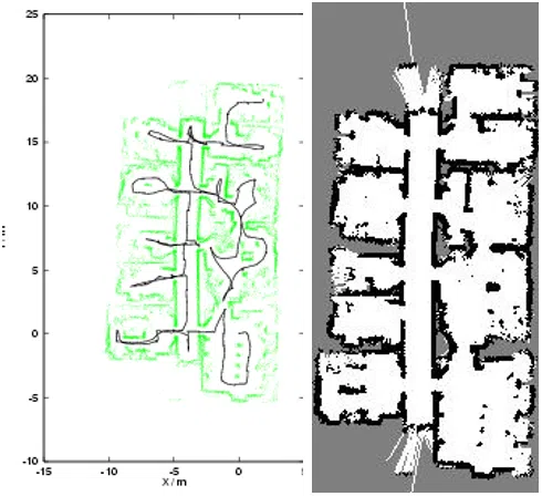
Fig. 1. Raw sensor data from the Artificial Intelligence Lab,
Freiburg, as in [6], showing the odometry trace and laser range-
finger readings.
smaller, more compact maps. This is done by fitting
a bounding box to the map that indicates the total
area covered by cells with occ
i
> 0. The measure is
calculated as
MC
2
= (x
max
x
min
) × (y
max
y
min
)
where x
max
and x
min
refer to the maximum and
minimum x-coordinates of the bounding box,
measured in number of grid cells.
Fitness Value: Finally, the two metrics are com-
bined as
F = MC
1
+ wMC
2
where the weight w = 0.3 determines the relative im-
portance of the two heuristics in the fitness function.
Note that better maps produce lower values of F.
C. Selection, Crossover and Mutation
The selection phase in a genetic algorithm involves
creating a “mating pool” by picking individual so-
lutions that are fitter with higher probability. The
selected individuals in the mating pool are then com-
bined to make a new population using the crossover
operator, with occasional small random changes due
to the mutation operator, described as follows.
In the GA presented here, the population is first
sorted according to the values produced by the fitness
function. Individuals are then assigned an offspring
count that is solely a function of their rank, using the
scheme proposed by Baker [1]. In this method, each
Fig. 2. Corrected sensor data obtained using only the fitness
function F = MC
1
and the corresponding gridmap.
string l is assigned an expected offspring count e
l
.
The fittest individual is assigned a value of e
l
= λ
max
,
the weakest individual is assigned a value of e
l
=
λ
min
, and the other members of the population are as-
signed an intermediate value by linear interpolation.
In this paper, values of λ
max
= 1.5 and λ
min
= 0.5
were used.
The standard selection method in a GA is the
weighted roulette wheel [7]. However, this scheme
has the problem that the best individuals may fail
to produce offspring in the next generation, resulting
in a so-called stochastic error [9]. Instead, a scheme
known as Remainder Stochastic Sampling Without
Replacement is used. Each individual is first allo-
cated offspring according to the integer part of e
l
in completely deterministic fashion. The remaining
strings needed to fill out the population are then
obtained randomly by generating new offspring for
each string with probability equal to the fractional
part of e
l
. “Without replacement” means that strings
can only be selected once in the non-deterministic
phase, so that a string with e
l
= 1.5 would receive
either 1 or 2 offspring in total.
Pairs of selected strings are then combined by
crossover. Multiple crossover sites are used, so that
the encoded values in the two mating strings are
completely mixed up in the two strings produced.
This is achieved by randomly choosing between
the two parents at each site in the chromosome.
Crossover is carried out with probability p = 0.85,
otherwise the selected strings are left unchanged.
Mutation is carried out by picking single values

Fig. 3. Corrected sensor data obtained using the full fitness
function F = MC
1
+ wMC
2
and the corresponding gridmap.
within the strings with very low probability p =
0.005 and replacing those values with randomly
generated values, as upon initialization.
V. EXPERIMENTAL RESULTS
The algorithm was first tested using data recorded
by a Pioneer I mobile robot equipped with a SICK
laser scanner at the Artificial Intelligence Lab of the
University of Freiburg [6]. The raw sensor data is
shown in Fig. 1. The genetic algorithm was run for
150 generations with a population size of 50, i.e., a
total of 7500 candidate maps were evaluated, taking
around 2 hours on a 200MHz Pentium II processor.
Fig. 4 shows the resulting fitness values produced, il-
lustrating the convergence of the algorithm over time.
The corrected sensor data obtained from the fittest
solution, together with the corresponding gridmap,
is shown in Fig. 3.
VI. CONCLUSIONS AND FUTURE WORK
The major contribution of this paper is that the
problem of simultaneous localization and mapping
(SLAM) has been defined for the first time as a
global optimization problem. A genetic algorithm
was developed to solve this problem, producing a
global solution by searching the space of possible
robot maps.
Genetic algorithms are particularly useful for solv-
ing environment modelling problems because they
Fig. 4. Fitness values over time for the genetic algorithm using
the data of Fig. 1, showing the fitness of both the best and median
members of the population in each generation.
exploit the building block hypothesis, whereby better
and better strings are constructed from the best
partial solutions (i.e., schemata or building blocks)
of previous generations [4]. Most real world envi-
ronments can be decomposed spatially into natu-
ral building blocks such as rooms, corridors, open
spaces, etc.
A major benefit of the approach is that it makes
very few assumptions about the underlying problem,
and the only critical parameter is the weighting
between the consistency and compactness heuristics
in the fitness function. A disadvantage of the ap-
proach at present is that it requires large amounts of
computation.
There are other possible algorithms for performing
global optimization [15], such as branch and bound
algorithms, simulated annealing, etc., which should
also be investigated. A further possibility would be
to combine the global search algorithm with a local
optimization method, e.g., EKF [5], consistent pose
estimation [10], relaxation [3], etc. In the case of
the GA, this could dramatically reduce the overall
computation time.
Another important direction is to implement an on-
line version of the algorithm suitable for use in real-
time on a self-navigating mobile robot. This would
involve continually searching the space of possible
maps while the robot is in motion, automatically ex-
tending the candidate maps with the incoming sensor
information. The current best map would be used
for decision making, e.g., path planning. A further
possibility would be to investigate implementation
of the algorithm on parallel processors, given the
parallel nature of evolutionary computation.

Citations
More filters
Journal ArticleDOI
TL;DR: An incremental SLAM algorithm is introduced that is derived from multigrid methods used for solving partial differential equations, which has an update time that is linear in the number of estimated features for typical indoor environments, even when closing very large loops.
Abstract: This paper addresses the problem of simultaneous localization and mapping (SLAM) by a mobile robot. An incremental SLAM algorithm is introduced that is derived from multigrid methods used for solving partial differential equations. The approach improves on the performance of previous relaxation methods for robot mapping, because it optimizes the map at multiple levels of resolution. The resulting algorithm has an update time that is linear in the number of estimated features for typical indoor environments, even when closing very large loops, and offers advantages in handling nonlinearities compared with other SLAM algorithms. Experimental comparisons with alternative algorithms using two well-known data sets and mapping results on a real robot are also presented.

406 citations

Journal ArticleDOI
Udo Frese1
TL;DR: A formal proof for approximate sparsity of so-called information matrices occurring in SLAM is sketched and supports the structure of uncertainty of an estimated map and provides a foundation for algorithms based on sparse informationMatrices.
Abstract: This paper aims at a discussion of the structure of the SLAM problem. The analysis is not strictly formal but based both on informal studies and mathematical derivation. The first part highlights the structure of uncertainty of an estimated map with the key result being "Certainty of Relations despite Uncertainty of Positions". A formal proof for approximate sparsity of so-called information matrices occurring in SLAM is sketched. It supports the above mentioned characterization and provides a foundation for algorithms based on sparse information matrices. Further, issues of nonlinearity and the duality between information and covariance matrices are discussed and related to common methods for solving SLAM. Finally, three requirements concerning map quality, storage space and computation time an ideal SLAM solution should have are proposed. The current state of the art is discussed with respect to these requirements including a formal specification of the term "map quality".

176 citations


Cites background or methods from "A genetic algorithm for simultaneou..."

  • ...Duckett (2003) searches through the space of possible robot trajectories using a genetic algorithm....

    [...]

  • ...topologies. Duckett (2003) searches through the space of possible robot trajectories using a genetic algorithm....

    [...]

Journal ArticleDOI
08 Dec 2003
TL;DR: In this article, the authors address the problem of mapping the features of a gas distribution by creating concentration gridmaps from the data collected by a mobile robot equipped with an electronic nose.
Abstract: This paper addresses the problem of mapping the features of a gas distribution by creating concentration gridmaps from the data collected by a mobile robot equipped with an electronic nose. By contrast to metric gridmaps extracted from sonar or laser range scans, a single measurement of the electronic nose provides information about a comparatively small area. To overcome this problem, a mapping technique is introduced that uses a Gaussian density function to model the decreasing likelihood that a particular reading represents the true concentration with respect to the distance from the point of measurement. This method is evaluated in terms of its suitability regarding the slow response and recovery of the gas sensors. The stability of the mapped features and the capability to use concentration gridmaps to locate a gas source are also discussed.

165 citations

Proceedings ArticleDOI
05 Dec 2005
TL;DR: The contribution of this paper is in the proposal of a hybrid technique to mitigate sample impoverishment such that the number of particles required and hence the computation complexities are reduced.
Abstract: The sample impoverishment problem in particle filters is investigated from the perspective of genetic algorithms. The contribution of this paper is in the proposal of a hybrid technique to mitigate sample impoverishment such that the number of particles required and hence the computation complexities are reduced. Studies are conducted through the use of Chebyshev inequality for the number of particles required. The relationship between the number of particles and the time for impoverishment is examined by considering the takeover phenomena as found in genetic algorithms. It is revealed that the sample impoverishment problem is caused by the resampling scheme in implementing the particle filter with a finite number of particles. The use of uniform or roulette-wheel sampling also contributes to the problem. Crossover operators from genetic algorithms are adopted to tackle the finite particle problem by re-defining or re-supplying impoverished particles during filter iterations. Effectiveness of the proposed approach is demonstrated by simulations for a monobot simultaneous localization and mapping application.

115 citations


Cites methods from "A genetic algorithm for simultaneou..."

  • ...In [17], a GA with a simple fitness function design was applied in mobile robot localization and mapping but insights into the algorithm were not reported either....

    [...]

Journal ArticleDOI
TL;DR: A general framework for modeling measurements is described, and the use of a Markov-chain Monte Carlo algorithm that uses specific instances of these models for odometry and appearance measurements to estimate the posterior distribution is described.
Abstract: While probabilistic techniques have previously been investigated extensively for performing inference over the space of metric maps, no corresponding general-purpose methods exist for topological maps. We present the concept of probabilistic topological maps (PTMs), a sample-based representation that approximates the posterior distribution over topologies, given available sensor measurements. We show that the space of topologies is equivalent to the intractably large space of set partitions on the set of available measurements. The combinatorial nature of the problem is overcome by computing an approximate, sample-based representation of the posterior. The PTM is obtained by performing Bayesian inference over the space of all possible topologies, and provides a systematic solution to the problem of perceptual aliasing in the domain of topological mapping. In this paper, we describe a general framework for modeling measurements, and the use of a Markov-chain Monte Carlo algorithm that uses specific instances of these models for odometry and appearance measurements to estimate the posterior distribution. We present experimental results that validate our technique and generate good maps when using odometry and appearance, derived from panoramic images, as sensor measurements.

102 citations


Cites background from "A genetic algorithm for simultaneou..."

  • ...Recent work by Duckett [7] on the SLAM problem is similar to our own, in the sense that he too deals with the space of possible maps....

    [...]

References
More filters
Proceedings Article
01 Jul 1985

967 citations


"A genetic algorithm for simultaneou..." refers methods in this paper

  • ...Individuals are then assigned an offspring count that is solely a function of their rank, using the scheme proposed by Baker [1]....

    [...]

  • ...REFERENCES [1] J. Baker....

    [...]

Journal ArticleDOI
01 Jun 2001
TL;DR: Addresses real-time implementation of the simultaneous localization and map-building (SLAM) algorithm and presents optimal algorithms that consider the special form of the matrices and a new compressed filler that can significantly reduce the computation requirements when working in local areas or with high frequency external sensors.
Abstract: Addresses real-time implementation of the simultaneous localization and map-building (SLAM) algorithm. It presents optimal algorithms that consider the special form of the matrices and a new compressed filler that can significantly reduce the computation requirements when working in local areas or with high frequency external sensors. It is shown that by extending the standard Kalman filter models the information gained in a local area can be maintained with a cost /spl sim/O(N/sub a//sup 2/), where N/sub a/ is the number of landmarks in the local area, and then transferred to the overall map in only one iteration at full SLAM computational cost. Additional simplifications are also presented that are very close to optimal when an appropriate map representation is used. Finally the algorithms are validated with experimental results obtained with a standard vehicle running in a completely unstructured outdoor environment.

836 citations


"A genetic algorithm for simultaneou..." refers background in this paper

  • ...The EKF requires analytic models of the vehicle motion and observations, it makes a number of assumptions which are often violated in practice, and it will fail whenever data association fails....

    [...]

  • ...A further possibility would be to combine the global search algorithm with a local optimization method, e.g., EKF [5], consistent pose estimation [10], relaxation [3], etc....

    [...]

  • ...The EKF is used for normal operation, only switching to the sampling technique to resolve ambiguities in landmark identification, e.g., when a large loop is to be closed....

    [...]

  • ...Nebot et al. [14] extended the EKF with a Monte Carlo sampling technique for handling possible data association errors....

    [...]

  • ..., EKF [5], consistent pose estimation [10], relaxation [3], etc....

    [...]

Journal ArticleDOI
TL;DR: This paper addresses the problem of building large-scale geometric maps of indoor environments with mobile robots as a constrained, probabilistic maximum-likelihood estimation problem, and devises a practical algorithm for generating the most likely map from data, along with the best path taken by the robot.
Abstract: This paper addresses the problem of building large-scale geometric maps of indoor environments with mobile robots It poses the map building problem as a constrained, probabilistic maximum-likelihood estimation problem It then devises a practical algorithm for generating the most likely map from data, along with the most likely path taken by the robot Experimental results in cyclic environments of size up to 80 by 25 meter illustrate the appropriateness of the approach

826 citations

Proceedings ArticleDOI
08 Nov 1999
TL;DR: A method, called local registration and global correlation, for reliable reconstruction of consistent global maps from dense range data, is presented, attractive because it is incremental, producing an updated map with every new sensor input; and runs in constant time independent of the size of the map.
Abstract: Mobile robots can use geometric or topological maps of their environment to navigate reliably. Automatic creation of such maps is still an unrealized goal, especially in environments that have large cyclical structures. Drawing on recent techniques of global registration and correlation, we present a method, called local registration and global correlation, for reliable reconstruction of consistent global maps from dense range data. The method is attractive because it is incremental, producing an updated map with every new sensor input; and runs in constant time independent of the size of the map (except when closing large cycles). A real-time implementation and results are presented for several indoor environments.

648 citations


"A genetic algorithm for simultaneou..." refers background or methods in this paper

  • ...V. EXPERIMENTAL RESULTS The algorithm was first tested using data recorded by a Pioneer I mobile robot equipped with a SICK laser scanner at the Artificial Intelligence Lab of the University of Freiburg [6]....

    [...]

  • ...[8] K. Konolige and K. Chou....

    [...]

  • ...The algorithm was first tested using data recorded by a Pioneer I mobile robot equipped with a SICK laser scanner at the Artificial Intelligence Lab of the University of Freiburg [6]....

    [...]

  • ...Gutmann and Konolige [6] considered mapping of large, circular environments using a combination of topological and metric representations....

    [...]

  • ...Raw sensor data from the Artificial Intelligence Lab, Freiburg, as in [6], showing the odometry trace and laser rangefinger readings....

    [...]

Proceedings Article
31 Jul 1999
TL;DR: CBML (correlation-based ML) permits video-rate localization using dense range scans, dynamic map updates, and a more precise error model than ML.
Abstract: Localization is one of the most important capabilities for autonomous mobile agents. Markov Localization (ML), applied to dense range images, has proven to be an effective technique. But its computational and storage requirements put a large burden on robot systems, and make it difficult to update the map dynamically. In this paper we introduce a new technique, based on correlation of a sensor scan with the map, that is several orders of magnitude more efficient than ML. CBML (correlation-based ML) permits video-rate localization using dense range scans, dynamic map updates, and a more precise error model than ML. In this paper we present the basic method of CBML, and validate its efficiency and correctness in a series of experiments on an implemented mobile robot base.

145 citations


"A genetic algorithm for simultaneou..." refers methods in this paper

  • ...Then a global correlation procedure [8] was used to detect when a previously visited location had been reached....

    [...]

Frequently Asked Questions (2)
Q1. What are the contributions in "A genetic algorithm for simultaneous localization and mapping" ?

This paper addresses the problem of simultaneous localization and mapping ( SLAM ) by a mobile robot. 

A further possibility would be to combine the global search algorithm with a local optimization method, e. g., EKF [ 5 ], consistent pose estimation [ 10 ], relaxation [ 3 ], etc. A further possibility would be to investigate implementation of the algorithm on parallel processors, given the parallel nature of evolutionary computation. Future work should also include more detailed theoretical and empirical analysis of the problem and the algorithm required to solve it, e. g., with respect to the fitness criteria needed for different environments.