scispace - formally typeset
Search or ask a question
Journal ArticleDOI

Age constraints of rock glaciers in the Southern Alps/New Zealand - Exploring their palaeoclimatic potential

09 Feb 2018-The Holocene (SAGE PublicationsSage UK: London, England)-Vol. 28, Iss: 5, pp 778-790
TL;DR: Two rock glaciers in the valley head of Irishman Stream in the central Ben Ohau Range, Southern Alps/New Zealand, have been investigated using the electronic Schmidt-hammer (SilverSchmidt).
Abstract: Two rock glaciers in the valley head of Irishman Stream in the central Ben Ohau Range, Southern Alps/New Zealand, have been investigated using the electronic Schmidt-hammer (SilverSchmidt). Longitu...

Summary (2 min read)

Introduction

  • Rock glaciers are ice-rich debris creeping with velocities of some centimetres to some metres per year.
  • Their development and evolution is highly sensitive to climatic parameters (Brazier et al., 1998; Humlum, 1998; Kääb et al., 2007); rock glaciers constitute thus an important potential as archive for the regional Late Glacial and Holocene palaeoclimatology.
  • Furthermore, rock glacier activity does exclude concurrent glacial activity.
  • These studies generally reveal considerable age variations on global and hemispheric scales.

Study area

  • The high-altitude valley head of Irishman Stream in the Ben Ohau Range between Lakes Ohau and Pukaki is located roughly 30 km southeast of the Main Divide of the Southern Alps.
  • It contains a number of separate rock glaciers – two selected for this study (Figures 1–3).
  • It comprises two separate segments indicated by a prominent bend in its flow line between ridges 3 and 4 at about 2025/2030 m a.s.l. (Figure 1).
  • This coincides with selective surface weathering and the common thin quartz veins, avoided with Schmidt-hammer sampling, stick out by up to 10 mm on Late Glacial boulders.
  • But it does not reach the central Ben Ohau Range.

Results

  • Application of the electronic Schmidt-hammer, the first such attempt in the context of SHD in New Zealand, yielded a total of c. 4500 sampled boulders during the brief site visits and proved to be very efficient.
  • Histograms are provided for these sites (Figures 4 and 5) that all passed the Kolmogorov– Smirnov test for normality.
  • Whereas the difference between lowermost and uppermost ridges on both rock glaciers is considerable (approximately R = 10), neighbouring surface ridges do in general not show any statistically significant differences in their means within the overlying trend of increasing R-values towards the rooting zone.
  • A few samples in 2016 were taken outside the surface ridges along the longitudinal profiles to gain comparative figures.
  • TCND-locations also constitute ridges with a similar micro-climatic environment.

Sites includeda Equationb

  • Only one sample (out of 27) needed to be rejected as potential outlier.
  • After correcting the raw data for the slight difference of instruments calibration (all 2014 data were reduced by R = 1; see above), all samples on individual sites were integrated accordingly resulting in sample sizes between 100 and 350 boulders each (Table 1).
  • It virtually comprises ‘fresh’ rock fall boulders only.
  • The age estimates for the rock glacier are, however, contradictory to previous work and clearly exclude substantial glacier activity during the later early, mid-, and late Holocene (Birkeland, 1982; see ‘Discussion’).

Discussion

  • The consistent decrease of R-values (and consequently increase of surface weathering grade and exposure age) along the longitudinal profiles towards the rock glacier front corresponds well with existing studies, for example, those of Frauenfelder et al. (2005), Kellerer-Pirklbauer (2008), Rode and Kellerer-Pirklbauer (2011) or Scapozza et al. (2014).
  • Such a process is reported by Frauenfelder et al. (2005), who measured an increase of R-value means at the active front of some of their studied rock glaciers because of toppling and relocation of boulders.
  • Because the authors followed well-established procedures with the construction of such SHD calibration curves (cf. Matthews et al., 2013, 2014; Matthews and Owen, 2010; Matthews and Winkler, 2011), they review their age estimates as reliable for this type of landform.
  • Whereas the age difference between lowermost and uppermost rock glacier ridges of their SHD age estimates clearly exceed the difference suggested by Birkeland (1982), his subdivision at least correctly reflects the close age between the lowermost rock glacier ridges and the inner Late Glacial/early-Holocene moraines.
  • If confirmed at other sites across the Southern Alps, rock glacier formation during the first part of the early Holocene also bears potential implications for the regional glacier history.

Conclusion

  • The authors study shows that SHD using an electronic Schmidt-hammer can successfully be applied for the dating of rock glaciers in the Southern Alps of New Zealand and is efficient with obtaining large sets of raw data.
  • Longitudinal transects on selected rock glaciers reveal a clear trend of decreasing R-values (increasing surface weathering and exposure age) from rock glacier rooting zones towards their front, only altered at the front of ‘active’ ridges by toppling and relocation of boulders.
  • Previously published numerical 10Be cosmogenic nuclide ages (Kaplan et al., 2010) enabled the calculation of SHD age-calibration curves and the lowermost transverse surface ridges of the rock glacier are dated to c. 12,000 and 10,500 years, respectively.
  • These age estimates indicate rock glacier initiation during or shortly after Termination 1, thereby requiring a fast disappearance of the former (Late Glacial) Irishman Stream glacier at the onset of the Holocene.
  • This assumed extended activity during the Holocene combined with the timing of their initiation has palaeoclimatic implications that need to be explored further once it is ensured it constitutes a regional pattern.

Did you find this useful? Give us your feedback

Figures (9)

Content maybe subject to copyright    Report

https://doi.org/10.1177/0959683618756802
The Holocene
1 –13
© The Author(s) 2018
Reprints and permissions:
sagepub.co.uk/journalsPermissions.nav
DOI: 10.1177/0959683618756802
journals.sagepub.com/home/hol
Introduction
Rock glaciers are ice-rich debris creeping with velocities of some
centimetres to some metres per year. Their genesis has been
largely discussed and two main modes of rock glacier formation
have been proposed (Barsch, 1988, 1996; Clark et al., 1998; Hae-
berli et al., 2006; Humlum, 1988; Whalley and Martin, 1992): (1)
periglacial rock glaciers resulting from the creep of ice-rich sedi-
ments in permafrost conditions and (2) glacigenic rock glaciers
deriving from the burial of small glaciers, mainly located in con-
tinental areas.
Their development and evolution is highly sensitive to cli-
matic parameters (Brazier et al., 1998; Humlum, 1998; Kääb
et al., 2007); rock glaciers constitute thus an important potential
as archive for the regional Late Glacial and Holocene palaeocli-
matology. Furthermore, rock glacier activity does exclude con-
current glacial activity. Their occurrence at specified location
potentially suitable for glaciers may, therefore, bear implications
and act as a proxy for limited extensions of glaciers within wider
regions at certain times (Böhlert et al., 2011a, 2011b). The general
palaeoclimatic potential of such locations within the transition
between glacial and periglacial process systems has recently been
highlighted by Matthews et al. (2017).
The dating of rock glaciers has been the subject of several
studies, indicating that in many cases, relict rock glaciers mainly
formed during the Late Glacial, whereas currently active rock gla-
ciers predominantly formed during the Holocene (e.g. Barsch,
1996; Scapozza, 2015). Dating methods applied (see Haeberli
et al. (2003) for a review) involve relative-age dating methods
such as, for example, the Schmidt-hammer (Kellerer-Pirklbauer
et al., 2008; Scapozza et al., 2014) or weathering-rind thickness
(Frauenfelder et al., 2005); numerical age-dating methods (radio-
carbon dating: Haeberli et al., 1999; terrestrial cosmogenic
nuclide dating (TCND): Böhlert et al., 2011a; Cossart et al.,
2010a; optical stimulated luminescence: Fuchs et al., 2013); or
age estimations based on current velocity fields measured with
aerial photogrammetry (Frauenfelder et al., 2005). These studies
generally reveal considerable age variations on global and hemi-
spheric scales. For instance, Böhlert et al. (2011a) provide evi-
dence of two phases of rock glacier formation immediately
following glacier retreat at the end of the Younger Dryas and
another subsequent phase starting between 10,000 and 6000 years
Age constraints of rock glaciers in the
Southern Alps/New Zealand – Exploring
their palaeoclimatic potential
Stefan Winkler
1
and Christophe Lambiel
2
Abstract
Two rock glaciers in the valley head of Irishman Stream in the central Ben Ohau Range, Southern Alps/New Zealand, have been investigated using the
electronic Schmidt-hammer (SilverSchmidt). Longitudinal profiles on both features reveal a consistent trend of decreasing R(Rebound)-values and, hence,
increasing weathering intensity and surface-exposure age on their numerous transverse surface ridges from rooting zone towards the front. Previously
published numerical ages obtained by terrestrial cosmogenic nuclide dating (TCND) allowed the calculation of a local Schmidt-hammer exposure-age
dating (SHD) age-calibration curve by serving as the required fixed points. Age estimates for the lowermost rock glacier surface ridges fall within the
early Holocene between 12 and 10.5 ka and indicate a fast disappearance of the Late Glacial glacier formerly occupying the valley head, followed by the
initiation of rock glacier formation around or shortly after the onset of the Holocene. Although it cannot be judged whether the rock glaciers investigated
were active within the entire Holocene or only repeatedly during multiple episodes within, their location and intact morphology exclude any substantial
glacial activity at Irishman Stream during the Holocene. This has considerable regional palaeoclimatic implications because it opens for the hypothesis that
climatic conditions during early Holocene were possibly comparatively dry and favourable for rock glacier initiation, but less so for glaciers. It would also
challenge the view that air temperature is the sole major climate driver of glacier variability in the Southern Alps. More work utilising the palaeoclimatic
potential of rock glaciers in the Southern Alps is advised.
Keywords
electronic Schmidt-hammer (SilverSchmidt), Holocene palaeoclimate, New Zealand, rock glaciers, Schmidt-hammer exposure-age dating (SHD),
Southern Alps
Received 6 October 2017; revised manuscript accepted 8 October 2017
1
Institute of Geography and Geology, Julius-Maximilians-Universität
Würzburg, Germany
2
Institute of Earth Surface Dynamics, University of Lausanne,
Switzerland
Corresponding author:
Stefan Winkler, Institute of Geography and Geology, Julius-Maximilians-
Universität Würzburg, Am Hubland, 97074 Würzburg, Germany.
Email: stefan.winkler@uni-wuerzburg.de
756802HOL
0010.1177/0959683618756802The HoloceneWinkler and Lambiel
research-article2018
Research paper

2 The Holocene 00(0)
ago in the European Alps. Early-Holocene ages of 10,000–8000
years are also reported by Kellerer-Pirklbauer et al. (2008) and
Kellerer-Pirklbauer (2008) from northern Europe, whereas a start
of formation just prior or during the Holocene Thermal Maximum
is given by Scapozza (2015) for the Swiss Alps. Younger ages
were, however, obtained by Cossart et al. (2010) who propose
late-Holocene ages of 2500 years in the French Alps. These pat-
terns likely reflect different regional palaeoclimatic developments
during the Holocene and underline their potential as climate
proxies.
Although not uncommon within the dryer eastern parts of the
Southern Alps, New Zealand, comparatively few previous studies
(e.g. Brazier et al., 1998; Jeanneret, 1975; Kirkbride and Brazier,
1995) have focused on the spatial distribution of rock glaciers or
their dynamics and evolution (see Sattler et al., 2016). The first
complete rock glacier inventory for the Southern Alps has only
been completed recently (Sattler et al., 2016) and neither a sys-
tematic monitoring programme nor detailed recent studies on
their age constraints have yet been undertaken. In our study area,
the Ben Ohau Range, rock glaciers have been incorporated in the
subdivision of Holocene deposits by Birkeland (1982) and their
stratification classification would suggest an early late-Holocene
age (3000–4000 years old), previous work of McGregor (1967)
even a somewhat younger age. But because these old studies
mainly apply relative-age dating methods and, for example, sig-
nificantly underestimate the ages of Late Glacial/early-Holocene
moraines studied by Kaplan et al. (2010), these old age estimates
seem unreliable (see below). Many rock glaciers in the Southern
Alps are located in cirques or valley heads formerly occupied by
glaciers during the Late Glacial. Obtaining information about the
timing of rock glacier initiation alongside age constraints for their
successive development and dynamics will, therefore, yield evi-
dence about the retreat of glaciers and a related decrease of glacial
activity at those sites to potentially help understanding the
regional palaeoclimatic conditions during the Late Glacial/Holo-
cene transition and the early Holocene.
It is a common view that glacier extension in the Southern
Alps has been continuously reduced during the Holocene caused
by long-term warming related to an underlying increase of solar
insolation following the orbital trend (Kaplan et al., 2013; Solo-
mina et al., 2015). There is, however, to date only fragmentary
reliable morphological evidence of the proposed larger early-
Holocene glacier expansion to confirm this (Kaplan et al., 2013;
Putnam et al., 2012), often explained by potentially efficient ero-
sional censoring sensu Kirkbride and Winkler (2012) in the highly
dynamic geomorphological environment. Model-based glacio-
logical studies postulating that regional Holocene glacier variabil-
ity very strongly depends on air temperatures (Anderson and
Mackintosh, 2006; Mackintosh et al., 2017) support such consid-
erations. The latter view is, however, challenged by work on gla-
cier fluctuations during the late 20th century CE and its conclusion
that atmospheric circulation patterns and precipitation changes
are equally important drivers for the maritime New Zealand gla-
ciers (Chinn et al., 2005; Clare et al., 2002). Furthermore, the
absence of widespread early-Holocene glacier advances would
correspond to the glacier chronology of mid-latitudinal mountain
glaciers in South America (cf. Kaplan et al., 2016; Menounos
et al., 2013; Strelin et al., 2014) and underline postulated telecon-
nections between both regions (Fitzharris et al., 2007). Chrono-
logical studies on rock glaciers in the Southern Alps could provide
an alternative way to assess this issue. Any formation of rock gla-
ciers at early stages during the Holocene would open for the
hypothesis that Late Glacial glaciers in the Southern Alps retreated
faster and were more significantly retracted immediately at the
onset of the early Holocene than previously anticipated. Keeping
in mind that rock glaciers required permafrost for their formation,
the early Holocene must (still) have been cold enough despite
comparatively moderately lowered air temperatures during the
Late Glacial (Doughty et al., 2013) and the following long-term
warming trend during the Holocene (Kaplan et al., 2013). There-
fore, retracted early-Holocene glaciers could provide a palaeocli-
matic signal for climatic conditions too dry for glaciers, thus
questioning the postulated strong dependency on temperature
conditions only. In many northern hemispheric regions, rock gla-
cier initiation following the mid-Holocene Thermal Optimum and
even as late as during the ‘Little Ice Age’ (LIA) (Janke et al.,
2013) reflects hemispheric climate patterns (Wanner et al., 2011).
By contrast, predominant rock glacier formation in the Southern
Alps taking place during the early Holocene would nicely under-
line different hemispheric patterns aligned with the respective
palaeoclimatic conditions.
But unlike single-age landforms related to comparatively
short-lived events (e.g. moraines formed during individual glacier
advances), obtaining age estimates for the initiation of rock gla-
cier formation and its subsequent development constitute a more
difficult methodological task. The characteristic rock glacier mor-
phology and dynamics require large sample sizes with any type of
surface-exposure dating because every single surface boulder
inhibits the potential of ongoing disturbance after its initial accu-
mulation. Following pilot studies of using the Schmidt-hammer
for (relative) dating of moraines on glacier forelands in Aoraki/Mt
Cook National Park (Winkler, 2005), Schmidt-hammer exposure-
age dating (SHD) has subsequently been successfully applied on
moraines as well as on (glacio)fluvial terraces in the Southern
Alps (Stahl et al., 2013; Winkler, 2009, 2014). In particular, the
widespread and comparatively homogeneous ‘greywacke’ of the
Torlesse composite terrane dominating east of the Main Divide
(Cox and Barrell, 2007) has proven to be suitable for Schmidt-
hammer studies, even indicating potential for the development a
regional age-calibration curve like Matthews and Owen (2010)
did in Southern Norway (Winkler and Corbett, 2014). But whereas
the Schmidt-hammer has already been applied on rock glaciers in
the European Alps, Iceland and Norway (e.g. Böhlert et al.,
2011b; Frauenfelder et al., 2005; Kellerer-Pirklbauer et al., 2008;
Matthews et al., 2013; Rode and Kellerer-Pirklbauer, 2011;
Scapozza et al., 2014), neither rock glaciers nor any other perigla-
cial landforms have previously been sampled in the Southern
Alps of New Zealand.
The primary aim of our study is to test whether SHD can suc-
cessfully be applied on rock glaciers in the Southern Alps and to
compare the results obtained with those of similar studies on rock
glaciers elsewhere. We will, furthermore, calculate a local SHD
age-calibration curve by using fixed points in the form of TCND
ages previously published by Kaplan et al. (2010) to gain age con-
straints for the rock glaciers investigated and enable interpretation
of their initiation and dynamics. Finally, by comparing this infor-
mation with established glacier chronologies, the potential of fur-
ther studies on rock glaciers as palaeoclimatic archives will be
discussed briefly.
Study area
The high-altitude valley head of Irishman Stream in the Ben
Ohau Range between Lakes Ohau and Pukaki is located roughly
30 km southeast of the Main Divide of the Southern Alps. It
contains a number of separate rock glaciers – two selected for
this study (Figures 1–3). Rock glacier 1 is a 400 m long land-
form composed of a succession of ridges and furrows. Altitudes
range from 1870 m a.s.l. at the front to 1990 m a.s.l. at the root-
ing zone (or head), which places this rock glacier below the sug-
gested lower limit of modern permafrost at c. 2000 m a.s.l.
(Brazier et al., 1998; Kirkbride and Brazier, 1995) and the mod-
elled permafrost distribution by Sattler et al. (2016). Whereas
rock glacier 1 is the lowermost rock glacier in the entire valley

Winkler and Lambiel 3
head, rock glacier 2 just reaches down to c. 2000 m a.s.l. It com-
prises two separate segments indicated by a prominent bend in
its flow line between ridges 3 and 4 at about 2025/2030 m a.s.l.
(Figure 1). The upper part trending relatively straight N–S
appears to have marginally overridden the lower part, indicating
a possible two-phase development.
The bedrock of the central Ben Ohau Range belongs to the
Rakaia terrane of the Torlesse composite terrane, mostly undif-
ferentiated dated as Permian to Triassic age (see Cox and Barrell
(2007) for details). The original quartzofeldsphatic sandstones
interbedded with silt and mudstones become more strongly meta-
morphosed and deformed towards the Alpine Fault northwest of
our study area, but east of the Main Divide, ‘greywacke’ domi-
nates. The ‘massive’ appearance of this rock type has previously
proven to be suitable for Schmidt-hammer measurements (Stahl
et al., 2013; Winkler, 2005). It weathers comparatively slowly
while changing its fresh greyish surfaces into pinkish colours.
This coincides with selective surface weathering and the common
thin quartz veins, avoided with Schmidt-hammer sampling, stick
out by up to 10 mm on Late Glacial boulders. But in general, the
surface morphology of boulders is minimal and of no concern for
the reliability of Schmidt-hammer measurements.
No detailed meteorological data are available for the study
area. Mean annual air temperatures (MAAT) for active rock gla-
ciers in the Southern Alps have been modelled to be positive and
among the highest reported on a global scale (see Sattler, 2016;
Sattler et al., 2016, for details). MAAT for Irishman Stream Val-
ley head should be around 0°C or slightly above at 2000 m a.s.l
and it has a southerly aspect. The high annual precipitation
likely exceeds 10,000 mm on western slopes and, thanks to an
‘overspill’ effect, is also typical for the Main Divide of the
Southern Alps itself and areas immediately to its east (Chater
and Sturman, 1998; Griffiths and McSaveney, 1983; Henderson
and Thompson, 1999). But it does not reach the central Ben
Ohau Range. Irishman Stream is located east of the 2000 mm
isohyet (Sattler, 2016; Tait et al., 2006). It seems too dry to sup-
port considerable Holocene glaciation, thus allowing the forma-
tion of rock glaciers practically absent in the more westward
parts of the Southern Alps.
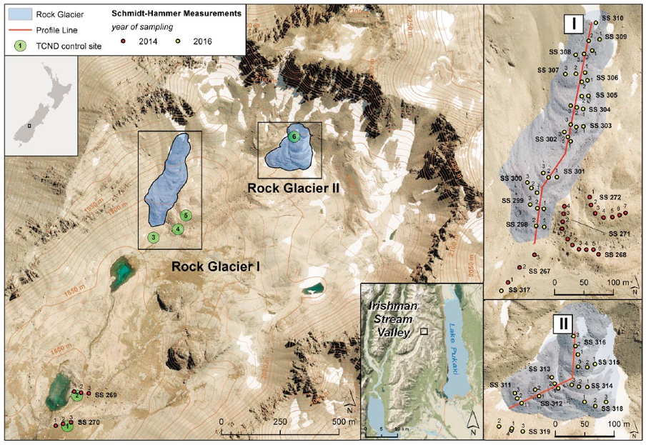
Figure 1. Aerial orthophoto with contours of the Irishman Stream valley head and its location within New Zealand and the Ben Ohau Range,
respectively (inserts). Main contours show 50-m intervals, auxiliary ones 10-m intervals. The longitudinal profiles for Schmidt-hammer sampling
on the two rock glaciers studied are shown alongside individual sample sites of 2014 and 2016. The TCND control sites refer to the ages
published by Kaplan etal. (2010), complemented by ‘young’ control site No.6 (see text for further details; modified from Land Information New
Zealand’s online database http://www.linz.govt.nz).
Figure 2. Aerial photo taken 3 March 1960 (non-rectified)
depicting the detailed morphology of the rock glaciers of the
Irishman Stream valley head. The rock glaciers investigated (I
and II) are indicated (cf. Figure 1), also three presumed late-
Holocene/‘Little Ice Age’ moraines not investigated here in detail
(see text; cf. Birkeland, 1982; Kaplan etal., 2010).

4 The Holocene 00(0)
Methods
Schmidt-hammer measurements
Schmidt-hammer measurements were carried out in February
2014 and January 2016. Electronic Schmidt-hammers (Silver-
Schmidt) of the N-type configuration with calibrated impact
energy of 2.207 Nm for the plunger (Proceq SA, 2012) were cho-
sen to ensure high efficiency with acquiring substantial raw data in
limited time. Although not attempted in our study, Winkler and
Matthews (2014) have previously shown that Q-(velocity) values
obtained by electronic Schmidt-hammers are interconvertible with
R-(rebound) values of mechanical instruments, thus allowing com-
parison with existing data series. For simplification, all Silver-
Schmidt Q-values indicating compressive strength of the boulder
surfaces sampled when measured using an inbuilt sensor to record
the rebound velocity of the plunger independent of its impact
direction are called ‘R-values’ hereafter. This anticipates the man-
ufacturers decision to re-name impact data ‘R-values’ with the
improved version of the electronic Schmidt-hammer (Rock-
Schmidt; cf. Proceq SA, 2014; Winkler et al., 2016). All instru-
ments used during fieldwork were checked for their calibration to
the manufacturers specifications. Detailed data from related pre-
and post-fieldwork tests on the specific manufacturers test anvil
additionally allowed correcting the raw data for minor differences
(~R = 1) that otherwise simply would have fallen within the
acceptable range of tolerance for calibration.
Abundance of boulders suitable for sampling and character of
the landforms investigated (rock glaciers and moraines) called for
an established sampling design of single impacts on large num-
bers of boulders. With one impact each on 50 randomly selected
boulders and multiple samples (preferably 3 or more) on every
individual site, potential postdepositional disturbance in high-
alpine environments was also addressed, and preferable to designs
using multiple impacts on fewer boulders. Individual samples
were finally combined for every site after they had shown consis-
tency without outliers. They are reported in the accepted standard
format as mean R-values with 95% confidence (α = 0.05) follow-
ing Shakesby et al. (2006) and others using the equation:
Xtsn
±−()
1
(1)
where
X
= arithmetic mean, s = sample standard deviation, t = Stu-
dent’s t statistic and n = number of impacts (sample size). Because
the rock glacier sites were initially expected to resemble a diachron-
ous rather than a synchronous surface (i.e. with a considerable spread
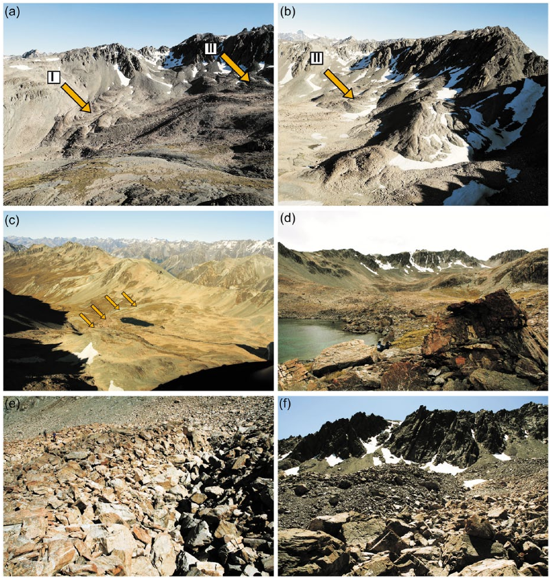
Figure 3. Irishman Stream valley head photos taken on 10 January 2016 and 15 February 2014 (Figure 3d): (a) The western valley head
with the rock glaciers 1 and 2 investigated in this study (cf. Figures 1 and 2); (b) the eastern valley head with additional rock glaciers showing
morphological signs of activity. (c) Displays the Late Glacial moraines of the former Late Glacial Irishman Stream Glacier as seen towards the
south (outermost Late Glacial moraine indicated by arrows); (d) depicts a view from TCND fixed point 2 in northern direction towards rock
glaciers and the valley headwall. (e) The typical ridge-and-furrow surface morphology of rock glacier; (f) was taken near the rooting zone of
rock glacier 2.

Winkler and Lambiel 5
of exposure ages as revealed by their R-values), detailed histograms
were produced for all sites for further interpretation. Except Kol-
mogorov–Smirnov tests for normality, no further statistical analysis
was performed at this stage.
In 2014, sampling was primarily carried out on Late Glacial
and early-Holocene moraines ridges investigated by Kaplan et al.
(2010) that eventually were used as fixed points for the calcula-
tion of SHD age-calibration curves (see below). Apart from one
site that was re-sampled to ensure reproducibility, sampling in
2016 focused on the selected rock glaciers in the form of two
longitudinal profiles from front to their rooting zone. Every indi-
vidual transverse surface ridge along these profiles mapped with
a differential GPS was sampled and treated as individual site. To
avoid potential influence of micro-climatic and micro-weathering
differences, furrows on the rock glacier surface between those
ridges were avoided (except for one test site).
Calculation of Schmidt-hammer exposure-age
calibration curves
Reliable and well-documented TCND ages from Irishman Stream
valley head reported by Kaplan et al. (2010) provided sufficient
fixed points in the form of numerical age information required for
the construction of a local age-calibration curve and subsequent
application of SHD as described in detail by Matthews and Owen
(2010) or Shakesby et al. (2011). Because Kaplan et al. (2010)
applied the
10
Be-production rates of Putnam et al. (2010), the only
available regional calibration scheme available to date, no re-
calculation of their original data seemed necessary (see discus-
sion). Late Glacial and early-Holocene moraine ridges investigated
in their study have, thanks to the restricted catchment of Irishman
Stream, the same source of debris with a visible dominance of
dumped former supraglacial debris on their surface. Schmidt-
hammer data were obtained on these moraines easily identifiable
on the ground, supplemented by a ‘young’ fixed point in the form
of ‘fresh’ appearing rock fall boulders at the uppermost rooting
zone of rock glacier 2. This site was given a fixed age of 100 ±
100 years as best estimate. For our fixed points, we did not use the
moraine ages calculated by Kaplan et al. (2010) as arithmetic
means of all related TCND ages but only those individual samples
located on the actual part of the moraine ridges we sampled with
the SilverSchmidt (see Figure 1). An arithmetic mean for fixed
point ages was only calculated if more than one individual sample
was available for the part of the moraine we sampled (Table 1).
The underlying rational was to avoid any potential influence of
minor lithological and micro-climatic differences, or complica-
tions caused during the uninvestigated history of moraine forma-
tion. Importance of the latter was recently highlighted at nearby
Mueller Glacier by Rezninchenko et al. (2016) who presented
evidence that the use of an arithmetic mean of related TCND ages
may not necessarily be an appropriate way to calculate a reliable
date for moraine formation in the specific geomorphological
environment of the Southern Alps.
The procedure of calculating SHD calibration curves followed
recent practice established and explained in detail by Matthews
and Winkler (2011), Matthews et al. (2014) or Winkler et al.
(2016). In their fundamental work on an ideal study site, Shakesby
et al. (2011) confirmed that the R-value–age relationship is best
described by a linear function. Local SHD studies (Winkler, 2014;
Winkler and Corbett, 2014) came to the same conclusion and cor-
respond to linear weathering intensity-age trends applied with the
weathering-rind-thickness dating method in the region (Birke-
land, 1982; Chinn, 1981, and others). Even with the limited
spread of available fixed points preventing better local re-assess-
ment, initial testing also demonstrated better fit of linear versus
exponential functions and provided, together with those above-
mentioned results, sufficient confidence about the applied shape
of the SHD calibration curves that follow the standard equation
for linear regression:
ya bx=+
(2)
where y = surface age in years, x = mean R-value, a = intercept
age and b = slope of the calibration curve.
Using all available fixed points, the local calibration curve is
defined by the equation:
yx
= 59963 1037 862 0690
..
(3)
and subsequently applied for the calculation of SHD age estimates
presented here. Three additional calibration curves were calcu-
lated by excluding one or two of those fixed points representing
the ‘inner moraines belt’ of Kaplan et al. (2010). These alternative
calibration curves resulted in only insignificant improvements of
R
2
(Table 2) and could easily be artefacts of fewer points generally
giving better fit with linear equations. Their similarity would any-
way have resulted in similar age estimates within the related error
ranges. Even if the possibility of postdepositional disturbance
because of higher altitude of the ‘inner moraines belt’ located
within altitudinal range of the lowermost rock glacier fronts justi-
fied initial testing, their application was not followed up. Because
the TCND ages serving as fixed points were not collected as part
of this study, we honestly felt unable to judge the representative-
ness of individual samples provided by Kaplan et al. (2010) and,
therefore, decided not to exclude any.
Table 1. Fixed points for the SHD age-calibration curve at Irishman Stream.
Site R-value
a
n (boulders) TCND age
b
n (samples) Sample IDs
c
1 54.18 ± 1.84 100 13100 ± 339 6 06-31 – 33,06-35 – 37
2 55.04 ± 1.46 150 12800 ± 300 2 06-41/42
3 55.49 ± 1.28 200 12100 ± 300 1 06-47
4 57.32 ± 1.08 300 11900 ± 300 1 06-28
5 54.58 ± 1.06 350 11650 ± 490 2 06-26/27
6 69.47 ± 1.26 50 100 ± 100
d
SHD: Schmidt-hammer exposure-age dating; TCND: terrestrial cosmogenic nuclide dating.
R-values and numerical ages of the selected fixed points for the SHD age-calibration curve of the Irishman Stream valley head (for position and altitude
cf. Figure 1; see also text and Kaplan etal. (2010) for the original TCND dataset and their sample IDs; Kaplan etal. used the
10
Be-production model of
Putnam etal. (2010), the only regional calibration scheme available for the Southern Alps to date).
a
Mean of R-values (SilverSchmidt) with 95% confidences (α = 0.05).
b
TCND ages calculated on the basis of results published by Kaplan etal. (2010). With more than one sample, the arithmetic mean has been calculated
(see text).
c
Original TCND sample IDs of Kaplan etal. (2010).
d
‘Young’ fixed point (see text).

Citations
More filters
Journal ArticleDOI
TL;DR: This work demonstrates that a CNN-based segmentation approach (U-net) in combination with training data directly derived from visual interpretation of UAV-based high-resolution RGB imagery for fine-grained mapping of vegetation species and communities and suggests that plant identification at very high spatial resolutions is facilitated through spatial patterns rather than spectral information.
Abstract: Recent technological advances in remote sensing sensors and platforms, such as high-resolution satellite imagers or unmanned aerial vehicles (UAV), facilitate the availability of fine-grained earth observation data. Such data reveal vegetation canopies in high spatial detail. Efficient methods are needed to fully harness this unpreceded source of information for vegetation mapping. Deep learning algorithms such as Convolutional Neural Networks (CNN) are currently paving new avenues in the field of image analysis and computer vision. Using multiple datasets, we test a CNN-based segmentation approach (U-net) in combination with training data directly derived from visual interpretation of UAV-based high-resolution RGB imagery for fine-grained mapping of vegetation species and communities. We demonstrate that this approach indeed accurately segments and maps vegetation species and communities (at least 84% accuracy). The fact that we only used RGB imagery suggests that plant identification at very high spatial resolutions is facilitated through spatial patterns rather than spectral information. Accordingly, the presented approach is compatible with low-cost UAV systems that are easy to operate and thus applicable to a wide range of users.

124 citations

Journal ArticleDOI
TL;DR: In this paper, the authors focus on rock glaciers as a paraglacial mountain landscape element and consider the relationships between rock glaciers and glacial, periglacial, and paragglacial processes, and show that even within a single region, rock glaciers may have varied origins and thus likely ages and different climatic and environmental controls.

86 citations

Journal ArticleDOI
TL;DR: CNN are powerful in harnessing high resolution data acquired from UAV to map vegetation patterns, based on low cost red, green, blue (RGB) sensors making the method accessible to a wide range of users.
Abstract: Unmanned Aerial Vehicles (UAV) greatly extended our possibilities to acquire high resolution remote sensing data for assessing the spatial distribution of species composition and vegetation characteristics. Yet, current pixel‐ or texture‐based mapping approaches do not fully exploit the information content provided by the high spatial resolution. Here, to fully harness this spatial detail, we apply deep learning techniques, that is, Convolutional Neural Networks (CNNs), on regular tiles of UAV‐orthoimagery (here 2–5 m) to identify the cover of target plant species and plant communities. The approach was tested with UAV‐based orthomosaics and photogrammetric 3D information in three case studies, that is, (1) mapping tree species cover in primary forests, (2) mapping plant invasions by woody species into forests and open land and (3) mapping vegetation succession in a glacier foreland. All three case studies resulted in high predictive accuracies. The accuracy increased with increasing tile size (2–5 m) reflecting the increased spatial context captured by a tile. The inclusion of 3D information derived from the photogrammetric workflow did not significantly improve the models. We conclude that CNN are powerful in harnessing high resolution data acquired from UAV to map vegetation patterns. The study was based on low cost red, green, blue (RGB) sensors making the method accessible to a wide range of users. Combining UAV and CNN will provide tremendous opportunities for ecological applications.

69 citations


Cites background from "Age constraints of rock glaciers in..."

  • ...Located in Mount Cook National Park (New Zealand), it comprises about 450 ha and is characterized by a sequence of lateral and latero-frontal moraines formed 125–3370 290 years ago (Winkler and Lambiel 2018)....

    [...]

Journal ArticleDOI
TL;DR: Schmidt-hammer exposure-age dating (SHD) was performed on blockfields and related landforms on Blaho, Southern Norway as mentioned in this paper, by developing a linear high-precision age-calibration curve through young and old adults.
Abstract: Schmidt-hammer exposure-age dating (SHD) was performed on blockfields and related landforms on Blaho, Southern Norway. By developing a linear high-precision age-calibration curve through young and ...

22 citations


Cites background or methods from "Age constraints of rock glaciers in..."

  • ...This is, moreover, not a trivial task as by contrast to quite detailed information on the horizontal ice sheet margins during the Late Glacial (Hughes et al. 2016), there is still relatively less knowledge about the exact mechanism and local timing of deglaciation within the mountainous parts of central Southern Norway (Dahl et al. 1997; Matthews and Winkler 2011)....

    [...]

  • ...In concert with McColl (2012) and Pánek et al. (2016), we consider our RSFs to have occurred during warm phases in the Holocene and the Late Glacial, namely the HTM and the Bølling-Allerød interstadial....

    [...]

  • ...This has recently been further improved by the introduction of an electronic version of the Schmidt hammer (Winkler and Matthews 2014) that already has been successfully applied on sorted stone circles (Winkler et al. 2016) and rock glaciers (Winkler and Lambiel 2018)....

    [...]

  • ...Furthermore, Tomkins et al. (2016, 2018) show the R-value–age relationship to be linear during the transition from arctic to more temperate conditions (post-LGM to Late Glacial)....

    [...]

  • ...…(Table 1), (3) the non-polymodal distribution suggesting no major post-depositional disturbance or polygenetic origin and (4) the established linear weathering relationship during the Holocene and into the Late Glacial (Matthews and Owen 2010; Matthews and Wilson 2015; Winkler and Lambiel 2018)....

    [...]

Journal ArticleDOI
TL;DR: In this article, 18 samples for 36Cl Cosmic-Ray Exposure (CRE) dating were taken from bedrocks, moraine boulders, fossil/active rock glaciers and debris-covered glaciers in Fremri-Grjotardalur and Holadalur cirques in the Viðinesdalur, Hofsdalur, and Heðinsdalur valleys.

22 citations

References
More filters
Journal ArticleDOI
TL;DR: In this article, a Holocene Climate Atlas (HOCLAT) is presented based on carefully selected 10,000-year-long time series of temperature and humidity/precipitation, as well as reconstructions of glacier advances.

713 citations


"Age constraints of rock glaciers in..." refers background in this paper

  • ..., 2013) reflects hemispheric climate patterns (Wanner et al., 2011)....

    [...]

  • ...In many northern hemispheric regions, rock glacier initiation following the mid-Holocene Thermal Optimum and even as late as during the ‘Little Ice Age’ (LIA) (Janke et al., 2013) reflects hemispheric climate patterns (Wanner et al., 2011)....

    [...]

Journal ArticleDOI
TL;DR: In this article, a review paper examines thermal conditions (active layer and permafrost), internal composition (rock and ice components), kinematics and rheology of creeping perennially frozen slopes in cold mountain areas.
Abstract: This review paper examines thermal conditions (active layer and permafrost), internal composition (rock and ice components), kinematics and rheology of creeping perennially frozen slopes in cold mountain areas. The aim is to assemble current information about creep in permafrost and rock glaciers from diverse published sources into a single paper that will be useful in studies of the flow and deformation of subsurface ice and their surface manifestations not only on Earth, but also on Mars. Emphasis is placed on quantitative information from drilling, borehole measurements, geophysical soundings, photogrammetry, laboratory experiments, etc. It is evident that quantitative holistic treatment of permafrost creep and rock glaciers requires consideration of: (a) rock weathering, snow avalanches and rockfall, with grain-size sorting on scree slopes; (b) freezing processes and ice formation in scree at sub-zero temperatures containing abundant fine material as well as coarse-grained blocks; (c) coupled thermohydro-mechanical aspects of creep and failure processes in frozen rock debris; (d) kinematics of non-isotropic, heterogeneous and layered, ice-rich permafrost on slopes with long transport paths for coarse surface material from the headwall to the front and, in some cases, subsequent re-incorporation into an advancing rock glacier causing corresponding age inversion at

427 citations


"Age constraints of rock glaciers in..." refers background in this paper

  • ...Their genesis has been largely discussed and two main modes of rock glacier formation have been proposed (Barsch, 1988, 1996; Clark et al., 1998; Haeberli et al., 2006; Humlum, 1988; Whalley and Martin, 1992): (1) periglacial rock glaciers resulting from the creep of ice-rich sediments in…...

    [...]

  • ...Their genesis has been largely discussed and two main modes of rock glacier formation have been proposed (Barsch, 1988, 1996; Clark et al., 1998; Haeberli et al., 2006; Humlum, 1988; Whalley and Martin, 1992): (1) periglacial rock glaciers resulting from the creep of ice-rich sediments in permafrost conditions and (2) glacigenic rock glaciers deriving from the burial of small glaciers, mainly located in continental areas....

    [...]

Journal ArticleDOI
TL;DR: In this paper, a method for estimating daily rainfall on a 0.05° latitude/longitude grid covering all of New Zealand for the period 1960-2004 using a second order derivative trivariate thin plate smoothing spline spatial interpolation model was presented.
Abstract: This study presents a method for estimating daily rainfall on a 0.05° latitude/longitude grid covering all of New Zealand for the period 1960–2004 using a second order derivative trivariate thin plate smoothing spline spatial interpolation model. Use of a hand-drawn (and subsequently digitised) mean annual rainfall surface as an independent variable in the interpolation is shown to reduce the interpolation error compared with using an elevation surface. This result is confirmed when long-term average annual rainfall data, derived from the daily interpolations, are validated using long-term river flow data. Copyright © 2006 Royal Meteorological Society

372 citations


"Age constraints of rock glaciers in..." refers background in this paper

  • ...Irishman Stream is located east of the 2000 mm isohyet (Sattler, 2016; Tait et al., 2006)....

    [...]

Journal ArticleDOI
01 May 2009-Science
TL;DR: In this article, the authors present a high-resolution 10Be chronology of glacier fluctuations in New Zealand's Southern Alps over the past 7000 years, including at least five events during the last millennium.
Abstract: Understanding the timings of interhemispheric climate changes during the Holocene, along with their causes, remains a major problem of climate science. Here, we present a high-resolution 10Be chronology of glacier fluctuations in New Zealand’s Southern Alps over the past 7000 years, including at least five events during the last millennium. The extents of glacier advances decreased from the middle to the late Holocene, in contrast with the Northern Hemisphere pattern. Several glacier advances occurred in New Zealand during classic northern warm periods. These findings point to the importance of regional driving and/or amplifying mechanisms. We suggest that atmospheric circulation changes in the southwest Pacific were one important factor in forcing high-frequency Holocene glacier fluctuations in New Zealand.

315 citations

Journal ArticleDOI
TL;DR: A global overview of glacier advances and retreats (grouped by regions and by millennia) for the Holocene is compiled from previous studies as mentioned in this paper, which reconstructs of glacier fluctuations are based on mapping and dating moraines defined by 14 C, TCN, OSL, lichenometry and tree rings (discontinuous records/time series).

308 citations


"Age constraints of rock glaciers in..." refers background in this paper

  • ...The timing of major Holocene glacier advances during the late-Holocene pre-dating the ‘LIA’ (Schaefer et al., 2009; Solomina et al., 2015; Winkler, 2014) coincides with increasing intensity of westerly airflow over New Zealand (Turney et al., 2017) and could give evidence that in addition to air…...

    [...]

  • ...The two uppermost moraines that likely correlate to similar features in Irishman Stream valley head have not been investigated and could represent the local ‘LIA’ or late-Holocene ‘LIA’-type events as their morphology appears quite ‘fresh’....

    [...]

  • ...The timing of major Holocene glacier advances during the late-Holocene pre-dating the ‘LIA’ (Schaefer et al., 2009; Solomina et al., 2015; Winkler, 2014) coincides with increasing intensity of westerly airflow over New Zealand (Turney et al., 2017) and could give evidence that in addition to air temperatures, also atmospheric circulation patterns and precipitation need to be considered as important drivers of glacier fluctuations in the Southern Alps....

    [...]

  • ...In many northern hemispheric regions, rock glacier initiation following the mid-Holocene Thermal Optimum and even as late as during the ‘Little Ice Age’ (LIA) (Janke et al., 2013) reflects hemispheric climate patterns (Wanner et al., 2011)....

    [...]

  • ...These R-values are similar to those of lateHolocene/‘LIA’ moraines in glacier forelands in Aoraki/Mt Cook (Winkler and Corbett, 2014) especially if a slightly different lithology (occurrence of harder semi-schist together with typical ‘greywacke’) is considered....

    [...]

Frequently Asked Questions (14)
Q1. What are the contributions mentioned in the paper "Age constraints of rock glaciers in the southern alps/new zealand – exploring their palaeoclimatic potential" ?

5 ka and indicate a fast disappearance of the Late Glacial glacier formerly occupying the valley head, followed by the initiation of rock glacier formation around or shortly after the onset of the Holocene. More work utilising the palaeoclimatic potential of rock glaciers in the Southern Alps is advised. 

Future work exploring the palaeoclimatic potential of rock glacier in the Southern Alps to establish consolidated regional patterns seems, therefore, of high priority. 

the most important outcome of Schmidthammer sampling along the longitudinal profiles is a remarkable, consistent trend of increasing R-values means from the lowermost to the uppermost surface ridges on both rock glaciers. 

If air temperatures are the most important drivers of glacier variability in the Southern Alps as claimed by Anderson and Mackintosh (2006) or Mackintosh et al. (2017), one would expect moraine sequences representing shortterm fluctuations during a constant decrease of glacier expansions and activity from the old early Holocene towards the ‘LIA’. 

The high annual precipitation likely exceeds 10,000 mm on western slopes and, thanks to an ‘overspill’ effect, is also typical for the Main Divide of the Southern Alps itself and areas immediately to its east (Chater and Sturman, 1998; Griffiths and McSaveney, 1983; Henderson and Thompson, 1999). 

retracted early-Holocene glaciers could provide a palaeoclimatic signal for climatic conditions too dry for glaciers, thus questioning the postulated strong dependency on temperature conditions only. 

Dating methods applied (see Haeberli et al. (2003) for a review) involve relative-age dating methods such as, for example, the Schmidt-hammer (Kellerer-Pirklbauer et al., 2008; Scapozza et al., 2014) or weathering-rind thickness (Frauenfelder et al., 2005); numerical age-dating methods (radiocarbon dating: Haeberli et al., 1999; terrestrial cosmogenic nuclide dating (TCND): Böhlert et al., 2011a; Cossart et al., 2010a; optical stimulated luminescence: Fuchs et al., 2013); or age estimations based on current velocity fields measured with aerial photogrammetry (Frauenfelder et al., 2005). 

If confirmed at other sites across the Southern Alps, rock glacier formation during the first part of the early Holocene also bears potential implications for the regional glacier history. 

Their study shows that SHD using an electronic Schmidt-hammer (SilverSchmidt) can successfully be applied for the dating of rock glaciers in the Southern Alps of New Zealand and is efficient with obtaining large sets of raw data. 

Their development and evolution is highly sensitive to climatic parameters (Brazier et al., 1998; Humlum, 1998; Kääb et al., 2007); rock glaciers constitute thus an important potential as archive for the regional Late Glacial and Holocene palaeoclimatology. 

To avoid potential influence of micro-climatic and micro-weathering differences, furrows on the rock glacier surface between those ridges were avoided (except for one test site). 

The primary aim of their study is to test whether SHD can successfully be applied on rock glaciers in the Southern Alps and to compare the results obtained with those of similar studies on rock glaciers elsewhere. 

But the model of a regional oscillating glacier retreat from Late Glacial until c. 6500 years ago (Putnam et al., 2012) cannot be supported on the basis of their results of high SHD age estimates of the lowermost rock glacier ridges and because of the excluding nature of rock glaciers and major glacier activity. 

It confirms the importance of their consistent sampling design to investigate surface ridges only and, furthermore, improves the reliability of the SHD calibration curve because the sampled fixed points/