scispace - formally typeset
Search or ask a question
Posted ContentDOI

Assessing hydrological sensitivity of grassland basins in the Canadian Prairies to climate using a basin classification–based virtual modelling approach

TL;DR: In this paper, a basin classification-based virtual modeling framework for a portion of the Canadian Prairies ecozone is proposed to evaluate regional scale impacts of climate change with relatively high spatial resolution, in a robust, effective and efficient manner.
Abstract: . Significant challenges from changes in climate and land-use face sustainable water use in the Canadian Prairies ecozone. The region has experienced significant warming since the mid 20th Century, and continued warming of an additional 2 °C by 2050 is expected. This paper aims to enhance understanding of climate controls on Prairie basin hydrology through numerical model experiments. It approaches this by developing a basin classification–based virtual modeling framework for a portion of the Prairie region, and applying the modelling framework to investigate the hydrological sensitivity of one Prairie basin class (High Elevation Grasslands) to changes in climate. High Elevation Grasslands dominate much of central and southern Alberta and parts of southwestern Saskatchewan with outliers in eastern Saskatchewan and western Manitoba. The experiments revealed that High Elevation Grasslands snowpacks are highly sensitive to changes in climate, but that this varies geographically. Spring maximum snow water equivalent in grasslands decreases 8% per degree °C of warming. Climate scenario simulations indicated a 2 °C increase in temperature requires at least an increase of 20% in mean annual precipitation for there to be enough additional snowfall to compensate for enhanced melt losses. The sensitivity in runoff is less linear and varies substantially across the study domain; simulations using 6 °C of warming and a 30% increase in mean annual precipitation yields simulated decreases in annual runoff of 40% in climates of the western Prairie but 55% increases in climates of eastern portions. These results can be used to identify those areas of the region that are most sensitive to climate change, and highlight focus areas for monitoring and adaptation. The results also demonstrate how a basin classification–based virtual modeling framework can be applied to evaluate regional scale impacts of climate change with relatively high spatial resolution, in a robust, effective and efficient manner.

Summary (2 min read)

Introduction

  • Modelling a specific basin to evaluate 45 processes or to simulate the effects of change entails large computational and labour costs and requires observations of the basin response with sufficient spatial and temporal coverage.
  • Prairie precipitation trends indicate more rain and less snow in the spring and fall (Shook and Pomeroy, 2012) and runoff generation has been shown to be shifting from snowmelt- to rainfall-driven in eastern Saskatchewan (Dumanski et al., 2015).
  • Recent analysis of hydrometric stations across the 80 region identified sub-regional trends in streamflow associated with drying in the west and south and wetting in the east and north, associated with physical landscape characteristics and climate (Whitfield et al. 2020).
  • This paper aims to demonstrate the utility of a basin classification–based virtual modelling approach for assessing the sensitivity of 110 Canadian Prairie catchments to climate.

Basin Classification

  • The classification of Canadian Prairie basins was based on the analyses of Wolfe et al. (2019), which divided over 4000 basins, each approximately 100 km2 in area, into seven broad classes, based on a suite of physio-geographic characteristics .
  • This was done because climate is introduced through the long meteorological time series used to drive the virtual basin model and in order to study climate sensitivity any classification that included historical climates could introduce bias.
  • Exclusion of climate had a limited impact on the basin classification, with the seven classes of basins 140 identified closely following the original classification.
  • The High Elevation Grasslands (HEG) class was selected for the development of the virtual basin model.
  • The suffix “- w” in the HRU name indicates HRUs in the wetland catena.

Model set-up and parameterization

  • The Cold Regions Hydrological Modelling platform (CRHM) was selected to develop the virtual 165 basin model, as CRHM is particularly suited for simulating the hydrology of the Canadian Prairies.
  • With the correct suite of modules, each representing a key hydrological process, CRHM has proven very capable of representing prairie 170 hydrological processes and accurately emulating water fluxes in this landscape (Fang and Pomeroy, 2009; Fang et al., 2010).
  • Runoff from the ‘wetland’ catena portion of the virtual basin (~33% of area) features a wetland complex HRU 190 within a landscape catena following a sequence from cultivated, to grassland, shrubland, and woodland HRUs .
  • For other HRUs, a minimum value of 0.001 was set to simulate the canopy effects of Prairie vegetation (crop residue, grass) on radiation for snowmelt.

Model application

  • To ensure that the role of climate variability across HEG was captured in streamflow simulations the model was run over a 46-year baseline period (1960–2006) driven using data from seven 255 locations.
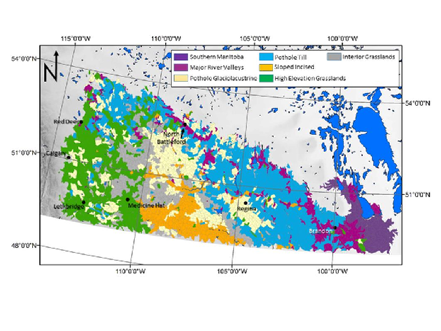
  • The locations were within and nearby the geographical extent of the HEG classification, and represented the variation in climate across the region .
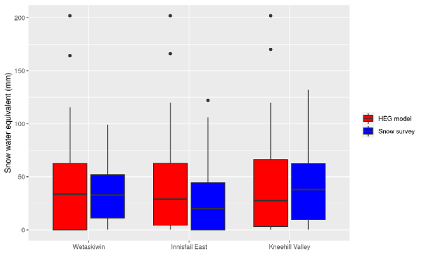
  • For this 290 reason, spring snow water equivalent (SWE) values from snow courses and mean annual hydrographs from hydrometric gauges at multiple sites within the HEG class were compared to virtual basin model outputs to establish that the virtual basin model was capturing the correct timing and magnitudes of important states and fluxes.
  • This method has the advantages of being 325 computationally inexpensive, while avoiding bias, and preserving the covariances among variables, which are important in modeling cold-regions processes (Shook and Pomeroy, 2010).
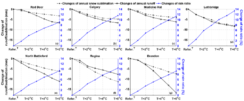
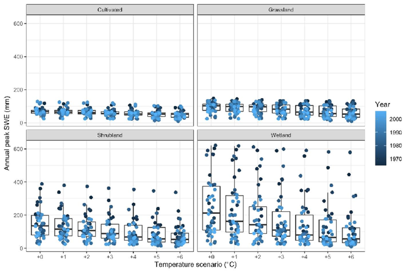
  • These scenarios were used with the model to quantify sensitivity of snow accumulation and annual runoff to climate change.

Results

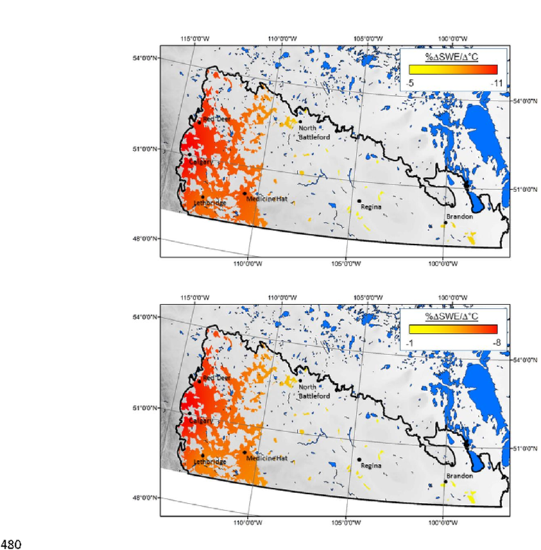
  • The HEG class occupies much of the western portion of the Canadian Prairies, and includes the 340 majority of southern Alberta and several isolated patches in both Saskatchewan and Manitoba .
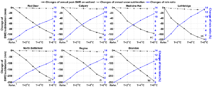
  • The date of annual peak SWE advances as annual air temperature warms .the authors.the authors.
  • Under a warmer and wetter climate (6°C 495 warming and 30% increase in annual precipitation) runoff in western portions still experience decreases, but runoff in climates such as Brandon’s increase and remain the same in climates such as Saskatchewan’s .
  • The consequence for streamflow is a 44% decline in annual volume in a drier HEG climate such as Medicine Hat’s (Table 4).

Conclusions

  • Virtual experiments have proven to be suitable to diagnose the hydrological response of basins in 595 this landscape.
  • The virtual basin model outputs are available from the authors by request.
  • CS and CJW conceived the study, also known as Author contributions.

Did you find this useful? Give us your feedback
Figures (12)

Content maybe subject to copyright    Report

1
Assessing hydrological sensitivity of grassland basins in the Canadian Prairies to climate using a
basin classificationbased virtual modelling approach
Christopher Spence
1*
, Zhihua He
2
, Kevin R. Shook
2
, Balew A. Mekonnen
3
, JohnW. Pomeroy
2
,
Colin J. Whitfield
4
, Jared D. Wolfe
5
5
* Corresponding author: Christopher Spence (chris.spence@canada.ca)
1
Environment and Climate Change Canada, Saskatoon, Saskatchewan, Canada
2
Centre for Hydrology, University of Saskatchewan, Saskatoon, Saskatchewan, Canada
3
Golder Associates, Calgary, Alberta, Canada
4
School of Environment and Sustainability, University of Saskatchewan, Saskatoon,
10
Saskatchewan, Canada
5
Saskatchewan Ministry of Environment, Regina, Saskatchewan, Canada
*corresponding author: chris.spence@canada.ca
Abstract
15
Significant challenges from changes in climate and land-use face sustainable water use in the
Canadian Prairies ecozone. The region has experienced significant warming since the mid 20th
Century, and continued warming of an additional 2°C by 2050 is expected. This paper aims to
enhance understanding of climate controls on Prairie basin hydrology through numerical model
experiments. It approaches this by developing a basin classificationbased virtual modeling
20
framework for a portion of the Prairie region, and applying the modelling framework to
investigate the hydrological sensitivity of one Prairie basin class (High Elevation Grasslands) to
changes in climate. High Elevation Grasslands dominate much of central and southern Alberta
and parts of southwestern Saskatchewan with outliers in eastern Saskatchewan and western
Manitoba. The experiments revealed that High Elevation Grasslands snowpacks are highly
25
sensitive to changes in climate, but that this varies geographically. Spring maximum snow water
equivalent in grasslands decreases 8% per degree °C of warming. Climate scenario simulations
indicated a 2°C increase in temperature requires at least an increase of 20% in mean annual
precipitation for there to be enough additional snowfall to compensate for enhanced melt losses.
The sensitivity in runoff is less linear and varies substantially across the study domain;
30
simulations using 6°C of warming and a 30% increase in mean annual precipitation yields
simulated decreases in annual runoff of 40% in climates of the western Prairie but 55% increases
in climates of eastern portions. These results can be used to identify those areas of the region that
are most sensitive to climate change, and highlight focus areas for monitoring and adaptation.
The results also demonstrate how a basin classificationbased virtual modeling framework can
35
be applied to evaluate regional scale impacts of climate change with relatively high spatial
resolution, in a robust, effective and efficient manner.
Key words: Prairie, basin classification, virtual experiments, climate change, snow, runoff
40
https://doi.org/10.5194/hess-2021-186
Preprint. Discussion started: 18 May 2021
c
Author(s) 2021. CC BY 4.0 License.

2
Introduction
Hydrological models are essential tools to understand hydrological processes and function at the
basin scale, and can also be used to diagnose how specific hydrological processes control
catchment responses to change (Rasouli et al., 2014). Modelling a specific basin to evaluate
45
processes or to simulate the effects of change entails large computational and labour costs and
requires observations of the basin response with sufficient spatial and temporal coverage.
Modelling of many individual basins is not efficient when attempting to predict regional
responses to changes in climate and/or land-use. Basin classification can regionalize
hydrological model outputs, based on the assumption that basins can be classified by their
50
characteristics and that basins of the same class respond similarly to changes in climate inputs or
their landscapes (e.g., McDonnell and Woods, 2004; Wagener et al., 2007). Parameterizing a
model based upon a representative or stylized basin of a given class allows the output to be
considered representative of all basins of that class. This assumption facilitates regionalization
as it does not necessarily require simulating the distinctive characteristics of every basin,
55
reducing cost and time required for large domain studies. Such a regionalization approach can
be used to assess the sensitivity of large diverse areas to stressors, such as land-use and climate
change.
One such region is the Canadian Prairie ecozone, that portion of the Great Plains of North
60
America that includes southern parts of the provinces of Alberta, Saskatchewan, and Manitoba
and Treaties 1, 2, 4, 6 and 7 in Western Canada (Spence et al., 2019), as mapped in Figure 2.
This region has a cold sub-humid to semi-arid climate and was covered by grassland and sparse
woodlands until the widespread adoption of cultivated agriculture in the late 19
th
and early 20
th
https://doi.org/10.5194/hess-2021-186
Preprint. Discussion started: 18 May 2021
c
Author(s) 2021. CC BY 4.0 License.

3
centuries. The region’s geomorphology was formed by glacial and post-glacial processes which
65
left numerous internally drained depressions and poorly defined drainage networks. Most of the
Canadian Prairies is in the Saskatchewan-Nelson River Basin, but relatively little runoff is
provided to the major rivers that traverse the region downstream of their mountain headwaters.
Local streams and prairie-derived rivers often have intermittent and highly variable streamflow.
These streams are important local sources of freshwater and are often managed to provide farm,
70
agricultural and municipal water supply and support natural lakes and reservoirs (Pomeroy et al.,
2005). Because they connect to larger systems only intermittently, a small headwaterbasin scale
approach is necessary to generate information about how their behaviour might be impacted by
the aforementioned stressors.
75
Western Canada, including the Canadian Prairies, has been subject to substantial climate
warming since the mid 20
th
century (DeBeer et al., 2016; Bush and Lemmen, 2019). Prairie
precipitation trends indicate more rain and less snow in the spring and fall (Shook and Pomeroy,
2012) and runoff generation has been shown to be shifting from snowmelt- to rainfall-driven in
eastern Saskatchewan (Dumanski et al., 2015). Recent analysis of hydrometric stations across the
80
region identified sub-regional trends in streamflow associated with drying in the west and south
and wetting in the east and north, associated with physical landscape characteristics and climate
(Whitfield et al. 2020). However, it is difficult to attribute streamflow response solely to climate
change because of impoundment of streams, widespread changes in agricultural practices and
wetland drainage since the 1950s (Ehsanzadeh, 2016). Wetland drainage has become
85
widespread in portions of the region (van Meter and Basu, 2015) and the loss of depressional
storage capacity associated with drainage enhances streamflow volumes (Tiner, 2003; Fang et
https://doi.org/10.5194/hess-2021-186
Preprint. Discussion started: 18 May 2021
c
Author(s) 2021. CC BY 4.0 License.

4
al., 2010; Wilson et al., 2019) and may alter the frequency, timing, and duration of regional
streamflow (Ehsanzadeh et al., 2012; Spence and Mengistu, 2019). Extrapolating intensive
studies of wetland drainage impact in individual basins (Wilson et al., 2019) can be challenging,
90
because basin response is a function of wetland distributions that control contributing area
dynamics (Stichling and Blackwell, 1957; Shaw et al., 2012; Shook and Pomeroy, 2011; Haque
et al. 2017, Spence and Mengistu, 2019). It is uncertain how hydrological fluxes and states in
Canadian Prairie basins will respond to continued climate change and wetland drainage. The
statistical modelling and small basin modelling studies cited here have provided an excellent
95
foundation, but an improved approach is needed to evaluate how changes in climate and
agricultural practices impact hydrological regimes more broadly across the region.
Here, a classification-based virtual modeling framework is proposed as a means to examine
hydrological sensitivity to different climate, land-use and wetland drainage. In this approach,
100
each basin class is modelled in a virtual manner (Weiler and McDonnell, 2004; Armstrong et al.,
2015); as a synthetic or generic basin with characteristics defined by the average or typical
condition of all basins from the same class. In this way, the basin characteristics can be
manipulated to determine how a typical basin may respond to change. There is evidence that
such an approach is viable, as virtual experiments have been used to evaluate hydrological
105
response to different conditions (Di Giammarco et al., 1996; Horn et al., 2005; Dunn et al., 2007;
Mallard et al., 2014; Seo and Schmidt, 2013, Lopez-Moreno et al., 2020), identify factors
influencing hydrological processes (e.g., Weiler and McDonnell, 2004), and study hydrological
controls on water chemistry (Weiler and McDonnell, 2006). This paper aims to demonstrate the
utility of a basin classificationbased virtual modelling approach for assessing the sensitivity of
110
https://doi.org/10.5194/hess-2021-186
Preprint. Discussion started: 18 May 2021
c
Author(s) 2021. CC BY 4.0 License.

5
Canadian Prairie catchments to climate. Two steps were taken to achieve this objective: (1)
development of a robust class-based virtual basin model for a portion of the Canadian Prairie
and; (2) exploration of virtual basin sensitivity of hydrological response to climate. This work
provides a foundation to extend the virtual basin modelling approach more broadly across the
Canadian Prairie to assess response to climate and land management scenarios.
115
Methodology
Framework of classification-based virtual basin modeling
A basin classificationbased virtual modelling platform has three main components: (1) a
classification analysis to derive virtual basin characteristics; (2) parameterization and evaluation
120
of a hydrological model of the virtual basin and (3) application of the model to evaluate response
to multiple scenarios (Figure 1).
Figure 1: Components of the classification-based virtual basin modeling platform.
125
https://doi.org/10.5194/hess-2021-186
Preprint. Discussion started: 18 May 2021
c
Author(s) 2021. CC BY 4.0 License.

Citations
More filters
01 Jan 2000
TL;DR: For example, this paper showed that the present mid-latitude rain belt would shift northward; snowmelt and spring runoff would occur earlier than at present; evapotranspiration would be greater; the greatest increases in temperatures will occur in the high latitudes, in winter, and over land; extreme weather events (droughts, storms, floods, ice jams, etc.) will be more frequent and more severe.
Abstract: Scientific evidence about global climate change and its consequences began to accumulate during the 1980s. In 1988, the United Nations Environment Programme and the World Meteorological Organization jointly established the Intergovernmental Panel on Climate Change (IPCC). The IPCC concluded in its Second Assessment Report (1996) that Earth has already warmed about 0.6 ˚C over the last century, and projected further increases of 1 to 3.5 ˚C by the year 2100. This projection is based on simulation of atmospheric circulation, the energy exchanges, and other important land/ocean/atmosphere interactions by General Circulation Models (GCMs). These models project climate (10-year or longer averages of weather conditions) over several decades, and give only large-scale predictions because grid spacing in most GCMs is between 2 and 5 degrees of longitude or latitude (about 150 to 360 km). Prediction on small time and space scale, needed for design and planning, are not possible at present. However, results from GCMs simulations suggest that the present mid-latitude rain belt would shift northward; snowmelt and spring runoff would occur earlier than at present; evapotranspiration would be greater; the greatest increases in temperatures will occur in the high latitudes, in winter, and over land; extreme weather events (droughts, storms, floods, ice jams, etc.) will be more frequent and more severe. Climate and hydrologic changes may result in important ecological and socioeconomic consequences. The impacts will vary from beneficial to catastrophic depending upon the magnitude and rate of change, the sensitivity of watersheds and ecosystems to change and the ability of natural or man-made systems to adapt to or mitigate that change.

6 citations

Posted ContentDOI
TL;DR: In this article, a semi-distributed hydrological model (MESH-PDMROF) that can simulate contributing area and streamflow was employed to compare the contribution area and flood frequency distributions in a southern Manitoba, Canada catchment and test the hypothesis that the relationship between a catchment's floods and contributing area is a power function that influences the form of regional flood-area relationships.
Abstract: While it is well known that the vast majority of the time only a portion of any watershed contributes runoff to the outlet, this extent is rarely documented The power-law form of the streamflow and contributing area (Q-Ac) relationship has been known for a half century, but it is uncommon for it to be quantified or its controls evaluated In this study a semi-distributed hydrological model (MESH-PDMROF) that can simulate contributing area and streamflow was employed to compare contributing area and flood frequency distributions in a southern Manitoba, Canada catchment and test the hypothesis that the relationship between a catchment’s floods and contributing area is a power function that influences the form of regional flood-area relationships The model simulated streamflow reasonably well (Nash Sutcliffe values = 062) Modelled estimates of the area contributing to the mean annual flood were much lower (03) than those derived from independent topographic analysis (09) described in earlier literature, even after bias and error corrections Estimates of the coefficient and exponent of the Q-Ac power law function ranged from 008–014 and 09–112, respectively Lower exponent values of regional flood frequency curves suggest they are a construct of Q-Ac curves from individual basins The non-linear nature of this relationship implies any contributing area change will have a profound impact on flood magnitude The mean annual flood of the major river in this region, the Red, has increased 33 % since 1987 Applying the coefficient and exponent ranges above suggests this is associated with an expansion in contributing areas of 29–38 % There are implications for the attribution of causes and mitigation of nutrient transport from regional watersheds However, how physiography and land and water management could change Q-Ac power law exponents is poorly known and MESH-PDMROF does not provide explicit estimates of the spatial distribution of contributing area These are areas encouraged for future research

4 citations

References
More filters
Journal ArticleDOI
TL;DR: In this article, the cold regions hydrological modelling platform (CRHM) was used to create a prairie hydrologogical model for Smith Creek Research Basin (~400 km2), east-central Saskatchewan, Canada.
Abstract: . The Cold Regions Hydrological Modelling platform (CRHM) was used to create a prairie hydrological model for Smith Creek Research Basin (~400 km2), east-central Saskatchewan, Canada. Physically based modules were sequentially linked in CRHM to simulate snow processes, frozen soils, variable contributing area and wetland storage and runoff generation. Five "representative basins" (RBs) were defined and each was divided into seven hydrological response units (HRUs): fallow, stubble, grassland, river channel, open water, woodland, and wetland. Model parameters were estimated using field survey data, LiDAR digital elevation model (DEM), SPOT 5 satellite imageries, stream network and wetland inventory GIS data. Model simulations were conducted for 2007/2008 and 2008/2009. No calibration was performed. The model performance in predicting snowpack, soil moisture and streamflow was evaluated against field observations. Root mean square differences (RMSD) between simulation and observations ranged from 1.7 to 25.2 mm and from 4.3 to 22.4 mm for the simulated snow accumulation in 2007/2008 and 2008/2009, respectively, with higher RMSD in grassland, river channel, and open water HRUs. Spring volumetric soil moisture was reasonably predicted compared to a point observation in a grassland area, with RMSD of 0.011 and 0.009 for 2008 and 2009 simulations, respectively. The model was able to capture the timing and magnitude of peak spring basin discharge, but it underestimated the cumulative volume of basin discharge by 32% and 56% in spring 2008 and 2009, respectively. The results suggest prediction of Canadian Prairie basin snow hydrology is possible with no calibration if physically based models are used with physically meaningful model parameters that are derived from high resolution geospatial data.

132 citations


"Assessing hydrological sensitivity ..." refers background or methods in this paper

  • ...With the correct suite of modules, each representing a key hydrological process, CRHM has proven very capable of representing prairie hydrological processes and accurately emulating water fluxes in this landscape (Fang and Pomeroy, 2009; Fang et al., 2010)....

    [...]

  • ...The routing length for each HRU was calculated using the modified Hack’s law length–area relationship, which was derived from a previous CRHM-PHM modelling study of Smith Creek in Saskatchewan (Fang et al., 2010; Pomeroy et al., 2010)....

    [...]

  • ...Previous studies have described the application of CRHM to Canadian Prairie basins, and its ability to represent the region’s predominant hydrological processes is well established (Fang et al., 2010)....

    [...]

  • ...With the correct suite of modules, each representing a key hydrological process, CRHM has proven very capable of representing prairie hydrological processes and accurately emulating water fluxes in this landscape (Fang and Pomeroy, 2009; Fang et al., 2010)....

    [...]

Journal ArticleDOI
TL;DR: In this article, the authors present virtual experiments that focus on quantifying the first-order controls on flow pathways and nutrient transport in hillslopes, and argue that this virtual experiment approach may provide a well-founded basis for defining the firstorder controls and linkages between hydrology and biogeochemistry at the hillslope scale and perhaps form a basis for predicting flushing and transport of labile nutrients from upland to riparian zones.

131 citations


"Assessing hydrological sensitivity ..." refers background in this paper

  • ...…et al., 1996; Horn et al., 2005; Dunn et al., 2007; Mallard et al., 2014; Seo and Schmidt, 2013; López-Moreno et al., 2020), identify factors influencing hydrological processes (e.g. Weiler and McDonnell, 2004), and study hydrological controls on water chemistry (Weiler and McDonnell, 2006)....

    [...]

  • ...Weiler and McDonnell, 2004), and study hydrological controls on water chemistry (Weiler and McDonnell, 2006)....

    [...]

Journal ArticleDOI
TL;DR: The control volume finite element (CVFE) method as discussed by the authors is a locally conservative formulation of the better known finite elements (FE) approach to deal more effectively with overland flow, resulting in a better representation of the gradients than that of the integrated finite difference (IFD) approach and allowing for the conservation of mass at local scale.

128 citations


"Assessing hydrological sensitivity ..." refers methods in this paper

  • ...…is evidence that such an approach is viable, as virtual experiments have been used to evaluate hydrological response to different conditions (Di Giammarco et al., 1996; Horn et al., 2005; Dunn et al., 2007; Mallard et al., 2014; Seo and Schmidt, 2013; López-Moreno et al., 2020), identify…...

    [...]

Journal ArticleDOI
TL;DR: The results suggest the need to gear restoration efforts toward understanding and recreating the size distribution and spatial organization of historical wetlands, rather than focusing primarily on an increase in overall area.
Abstract: More than 50% of global wetland area has been lost over the last 200 years, resulting in losses of habitat and species diversity as well as decreased hydrologic and biogeochemical functionality. Recognition of the magnitude of wetland loss as well as the wide variety of ecosystem services provided by wetlands has in recent decades led to an increased focus on wetland restoration. Restoration activities, however, often proceed in an ad hoc manner, with a focus on maximizing the total restored area rather than on other spatial attributes of the wetland network, which are less well understood. In this study, we have addressed the question of how human activities have altered the size distribution and spatial organization of wetlands over the Prairie Pothole Region of the Des Moines Lobe using high- resolution LIDAR data. Our results show that as well as the generally accepted 90% loss of depressional wetland area, there has been a preferential loss of smaller wetlands, with a marked alteration of the historical power-law relationship observed between wetland size and frequency and a resulting homogenization of the wetland size distribution. In addition, our results show significant decreases in perimeter-to-area ratios, increased mean distances between wetlands, particularly between smaller wetlands, and a reduced likelihood that current wetlands will, be located in upland areas. Such patterns of loss can lead to disproportionate losses of ecosystem services, as smaller wetlands with larger perimeter-to- area ratios have been found to provide higher rates of biogeochemical processing and groundwater recharge, while increased mean distances between wetlands hinder species migration and thus negatively impact biodiversity. These results suggest the need to gear restoration efforts toward understanding and recreating the size distribution and spatial organization of historical wetlands, rather than focusing primarily on an increase in overall area.

128 citations


"Assessing hydrological sensitivity ..." refers background in this paper

  • ...Wetland drainage has become widespread in portions of the region (van Meter and Basu, 2015), and the loss of depressional storage capacity associated with drainage enhances streamflow volumes (Tiner, 2003; Wilson et al., 2019) and may alter the frequency, timing, and duration of regional streamflow…...

    [...]

Journal ArticleDOI
TL;DR: In this article, the authors developed a model describing snowmelt infiltration into frozen soils, based on the concept that for practical purposes the infiltration potential of frozen soils may be generally categorized as (1) restricted: impervious; (2) unlimited: capable of infiltrating the snow cover water equivalent; and (3) limited: infiltration is governed by the snow-cover water equivalent and the ice content of the soil at the time of melt.
Abstract: A major limitation of existing operational systems when applied to forecasting or synthesizing streamflow from snowmelt on watersheds in many pans of central and northern Canada is that they are incapable of accurately simulating the process of infiltration into frozen soils. The results and discussion in the paper provide a method of overcoming the problem in areas of climatic and physiographic conditions similar to those of the Prairies.Details outlining the development of a model describing snowmelt infiltration into frozen soils are presented. The model is based on the concept that for practical purposes the infiltration potential of frozen soils may be generally categorized as (1) restricted: impervious; (2) unlimited: capable of infiltrating the snow-cover water equivalent; and (3) limited: infiltration is governed by the snow-cover water equivalent and the ice content of the soil at the time of melt. An empirical relationship for calculating infiltration into frozen soils of "limited" potential is ...

122 citations


"Assessing hydrological sensitivity ..." refers methods in this paper

  • ...Infiltration to unfrozen and frozen soils was calculated by the Prairie Infiltration module with algorithms based on Ayers (1959) and Gray et al. (1985), respectively....

    [...]

Frequently Asked Questions (2)
Q1. What contributions have the authors mentioned in the paper "Assessing hydrological sensitivity of grassland basins in the canadian prairies to climate using a basin classification–based virtual modelling approach" ?

This paper aims to enhance understanding of climate controls on Prairie basin hydrology through numerical model experiments. It approaches this by developing a basin classification–based virtual modeling 20 framework for a portion of the Prairie region, and applying the modelling framework to investigate the hydrological sensitivity of one Prairie basin class ( High Elevation Grasslands ) to changes in climate. The sensitivity in runoff is less linear and varies substantially across the study domain ; 30 simulations using 6°C of warming and a 30 % increase in mean annual precipitation yields simulated decreases in annual runoff of 40 % in climates of the western Prairie but 55 % increases in climates of eastern portions. 

Outputs of virtual experiments are less useful in predicting exact future system states than in specifying how alternative climate possibilities would alter hydrological behaviour. 630 Data Availability: All model forcing datasets used in this research are publicly available and can be accessed via the references and links provided.