scispace - formally typeset
Search or ask a question
Journal ArticleDOI

Classification of sensor independent point cloud data of building objects using random forests

TL;DR: A generic approach to automatically identify structural elements for the purposes of Scan-to-BIM by taking a set of planar primitives that are pre-segmented from the point cloud.
Abstract: The Architectural, Engineering and Construction (AEC) industry is looking to integrate Building Information Modeling (BIM) for existing buildings. Currently these as-built models are created manually, which is time-consuming. An important step in the automated Scan-to-BIM procedure is the interpretation and classification of point cloud data. This is computationally challenging due to the sheer size of point cloud data for an entire building. Additionally, the variety of objects makes classification problematic. Existing methods integrate prior knowledge from the sensors or environment to improve the results. However, these approaches are therefore often case specific and thus have limited applicability. The goal of this research is to provide a method that is independent of any sensor or scene within a building environment. Furthermore, our method processes the entire building simultaneously, resulting in more distinct local and contextual features. This paper presents a generic approach to automatically identify structural elements for the purposes of Scan-to-BIM. More specifically, a Random Forests classifier is employed for the classification of the floors, ceilings, roofs, walls and beams. As input, our algorithm takes a set of planar primitives that are pre-segmented from the point cloud. This significantly reduces the data while maintaining accuracy. Both contextual and geometric features are used to describe the observed patches. The algorithm is evaluated using realistic data for a wide variety of existing buildings including houses, school facilities, a factory, a castle and a church. The experiments prove that the proposed algorithm is capable of properly labeling 87% of the structural elements with an average precision of 85% in highly cluttered environments without the support of the sensors position. In future work, the classified patches will be processed by class-specific reconstruction algorithms to create BIM geometry.
Summary (2 min read)

1. Introduction

  • The implementation of Building Information Modelling (BIM) for existing buildings is gaining popularity.
  • Experiencing the advantage of BIM for new constructions, the industry now looks to implement as-built BIM.
  • These as-built models store an immense amount of information about a building at the varying stages of the construction’s life cycle [1].
  • More specifically, structural elements such as floors, ceilings, roofs, walls and beams are automatically identified in existing structures.
  • 35 In Section 4 the methodology is presented.

2. Background

  • The procedure of converting point cloud data to BIM geometry is referred40 to as Scan-to-BIM.
  • Second, each cluster is provided with a class label.
  • Examples of local geometric features are the area, surface dimensions and orientation.
  • Heuristic models are based on user defined rules in a certain structure.
  • Alternatively, machine learning algorithms are60 employed such as Discriminant Analysis (DA), Decision Trees, Support Vector Machines (SVM), Neural Networks (NN), Probabilistic Graphical Models (PGM), etc. [8, 12, 13, 16, 17, 18, 19].

4.2. Model formulation

  • Each tree consists of a series of binary splits that separate the input variables.
  • The Random Forests model is trained using leave-p-out cross validation.
  • This intuitive procedural programming platform allows for flexible data processing and evaluation.
  • The classified patches are exported to the Rhinoceros model space for185 validation and further processing.

5. Experiments

  • 10 structures including houses, offices, industrial buildings and churches were used for training and testing (Fig 5).
  • The test sites were acquired under realistic conditions including clutter, occlusions, traffic, etc.
  • Ghz with 4 cores and 4 hyperthreads and 32GB RAM.
  • Over 90,000 surfaces were computed for the projects.
  • All 17 predictors from table 1 were considered for the classification of the observations.

5.1. Performance

  • The classification results are depicted in the confusion matrices in Fig.7.
  • This is very accurate given the large variety of buildings and objects that were evaluated.
  • Increased confusion rates are observed between the walls and clutter classes as well as the ceiling and roof classes.
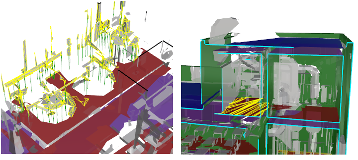
  • This is due to the fact that several data sets do not have roofs making the top ceilings harder to230 interpret (Fig.8b).
  • Several misclassifications are due to their sensor independent approach.

5.2. Comparison

  • The authors compared the results of the Random Forests classifier with other common machine learning methods.
  • Table 2 depicts the results of the model performance for K-Nearest Neighbours (KNN), a multiceptron Neural Network (NN), Support Vector Machines (SVM) and boosted decision trees.
  • All models240 were tested with the same predictors and data as the proposed model.
  • This proves that the used predictors are both distinct and robust for the detection of structural elements in cluttered and noisy environments.
  • Since their approach focusses on post-processing applications, the training time is of lesser concern.

6. Discussion and Conclusion

  • More specifically, the data is pre-segmented and processed by machine learning algorithms to label the floors, ceilings, roofs, beams, walls and clutter in noisy and occluded environ-255 ments.
  • This allows for the processing of larger data sets and provides additional features.
  • Some classes underperform due to the large variance in feature values within the265 class.
  • This will enhance the current classification and allows for the processing of non-planar classes such as cylindrical beams280 and pipes as well as furniture.

Did you find this useful? Give us your feedback

Figures (10)
Citations
More filters
Journal ArticleDOI
TL;DR: A novel method for reconstructing parametric, volumetric, multi-story building models from unstructured, unfiltered indoor point clouds with oriented normals by means of solving an integer linear optimization problem.
Abstract: We present a novel method for reconstructing parametric, volumetric, multi-story building models from unstructured, unfiltered indoor point clouds with oriented normals by means of solving an integer linear optimization problem. Our approach overcomes limitations of previous methods in several ways: First, we drop assumptions about the input data such as the availability of separate scans as an initial room segmentation. Instead, a fully automatic room segmentation and outlier removal is performed on the unstructured point clouds. Second, restricting the solution space of our optimization approach to arrangements of volumetric wall entities representing the structure of a building enforces a consistent model of volumetric, interconnected walls fitted to the observed data instead of unconnected, paper-thin surfaces. Third, we formulate the optimization as an integer linear programming problem which allows for an exact solution instead of the approximations achieved with most previous techniques. Lastly, our optimization approach is designed to incorporate hard constraints which were difficult or even impossible to integrate before. We evaluate and demonstrate the capabilities of our proposed approach on a variety of complex real-world point clouds.

116 citations


Cites methods from "Classification of sensor independen..."

  • ...[31] employ a machine learning approach to classify structural elements such as walls, floors, ceilings, and beams in point cloud data....

    [...]

Journal ArticleDOI
TL;DR: This research helps establish the state-of-the-art of DT in the civil engineering sector and suggests future DT development by extracting DT research clusters based on the co-occurrence analysis of paper keywords' and the relevant DT constituents.

107 citations

Journal ArticleDOI
TL;DR: This paper aims to develop, explore and validate reliable and efficient automated procedures for the classification of 3D data (point clouds or polygonal mesh models) of heritage scenarios and demonstrates that the proposed approach is reliable and replicable and it is effective for restoration and documentation purposes.
Abstract: In recent years, the use of 3D models in cultural and archaeological heritage for documentation and dissemination purposes is increasing. The association of heterogeneous information to 3D data by means of automated segmentation and classification methods can help to characterize, describe and better interpret the object under study. Indeed, the high complexity of 3D data along with the large diversity of heritage assets themselves have constituted segmentation and classification methods as currently active research topics. Although machine learning methods brought great progress in this respect, few advances have been developed in relation to cultural heritage 3D data. Starting from the existing literature, this paper aims to develop, explore and validate reliable and efficient automated procedures for the classification of 3D data (point clouds or polygonal mesh models) of heritage scenarios. In more detail, the proposed solution works on 2D data (“texture-based” approach) or directly on the 3D data (“geometry-based approach) with supervised or unsupervised machine learning strategies. The method was applied and validated on four different archaeological/architectural scenarios. Experimental results demonstrate that the proposed approach is reliable and replicable and it is effective for restoration and documentation purposes, providing metric information e.g. of damaged areas to be restored.

94 citations


Cites background from "Classification of sensor independen..."

  • ...2, is one of the most used supervised learning algorithms for classification problem [63,64]....

    [...]

Journal ArticleDOI
TL;DR: A summary of the efforts of the past ten years in automating the digital modeling of existing buildings by applying reality capture devices and computer vision algorithms, with a particular focus on object recognition methods.

58 citations

Journal ArticleDOI
TL;DR: In this article, the authors focus on the use of BIM sustainability design tools in refurbishment projects, to achieve energy efficient buildings and achieve sustainability criteria for refurbishing non-domestic buildings.
Abstract: Growing climate change challenges and increasingly strict sustainability standards have led to a significant growth in the need for building refurbishment projects which are essentially focused on retrofitting in order to make them low carbon, energy efficient and environmentally friendly. The Waste and Resources Action Programme (WRAP) suggested that Building Information Modelling (BIM) should be used to achieve sustainability requirements during refurbishment projects as a correspondence to the National Audit Office (NAO) sustainability report. BIM is now widely advocated as the preferred tool for the management and co-ordination of design and construction data using object- oriented principles. The successful integration of environmental assessment into BIM for the whole of the construction lifecycle has not yet been achieved. The potential for using BIM in refurbishment projects specifically for achieving and managing sustainability requirements has not been yet critically reviewed or put into practice. This paper focuses on the use of BIM sustainability design tools in refurbishment projects, to achieve energy efficient buildings and achieve sustainability criteria for refurbishing non-domestic buildings. A critical lens is cast on the current literature in the domains of sustainable designs and the associated implications of the sustainability decision-support tools in BIM. The research also reviews the practicality of the existing sustainability decision-support tools that are currently used to assist with achieving environmental scheme certifications such as BREEAM and LEED for refurbishment projects.

52 citations

References
More filters
Journal ArticleDOI
TL;DR: A new method for the detection of vegetation in LiDAR data that uses only three input parameters and allows for efficient compensation between completeness and correctness, without significantly affecting the F1-score is proposed.
Abstract: This paper proposes a new method for the detection of vegetation in LiDAR data. As vegetation points are characterised by non-linear distributions, they are efficiently recognised based-on large errors obtained when applying the local fitting of planar surfaces. In addition, three contextual filters are introduced capable of dealing with those exceptions that do not conform with previous interpretations. Namely, they are designed for detecting overgrowing vegetation, small objects attached to the planar surfaces (such as balconies, chimneys, and noise within the buildings) and small objects that do not belong to vegetation (vehicles, statues, fences). During the validation, the proposed method achieved over 97% correctness as well as completeness of vegetation recognition in rural areas while its average accuracy in urban settings was 90.7% in terms of F1-scores. The method uses only three input parameters and allows for efficient compensation between completeness and correctness, without significantly affecting the F1-score. Sensitivity analysis of the method also confirmed the robustness against a sub-optimal definition of the input parameters.

34 citations

Journal ArticleDOI
TL;DR: Based on segmented point clouds, the creation of as-built BIM is considered and the classification of planes into several categories is proposed, but the potential use of point clouds acquired outside buildings is also considered.
Abstract: . In this paper, a three steps segmentation approach is proposed in order to create 3D models from point clouds acquired by TLS inside buildings. The three scales of segmentation are floors, rooms and planes composing the rooms. First, floor segmentation is performed based on analysis of point distribution along Z axis. Then, for each floor, room segmentation is achieved considering a slice of point cloud at ceiling level. Finally, planes are segmented for each room, and planes corresponding to ceilings and floors are identified. Results of each step are analysed and potential improvements are proposed. Based on segmented point clouds, the creation of as-built BIM is considered in a future work section. Not only the classification of planes into several categories is proposed, but the potential use of point clouds acquired outside buildings is also considered.

34 citations

Journal ArticleDOI
TL;DR: The paper proposes to reconstruct a building facade and recognize its surface materials from images taken from various points of view to serve as initial steps towards automatic generation of as-built BIM.
Abstract: As-built building information model (BIM) is an urgent need of the architecture, engineering, construction and facilities management (AEC/FM) community. However, its creation procedure is still labor-intensive and far from maturity. Taking advantage of prevalence of digital cameras and the development of advanced computer vision technology, the paper proposes to reconstruct a building facade and recognize its surface materials from images taken from various points of view. These can serve as initial steps towards automatic generation of as-built BIM. Specifically, 3D point clouds are generated from multiple images using structure from motion method and then segmented into planar components, which are further recognized as different structural components through knowledge based reasoning. Windows are detected through a multilayered complementary strategy by combining detection results from every semantic layer. A novel machine learning based 3D material recognition strategy is presented. Binary classifiers are trained through support vector machines. Material type at a given 3D location is predicted by all its corresponding 2D feature points. Experimental results from three existing buildings validate the proposed system.

33 citations

Journal ArticleDOI
TL;DR: An automated procedure to convert raw point clouds into semantically-enriched building models and mainly focuses on a geometrical complexity typical of modern buildings with clear prevalence of planar features is presented.
Abstract: . Terrestrial Laser Scanning data are increasingly used in building survey not only in cultural heritage domain but also for as-built modelling of large and medium size civil structures. However, raw point clouds derived from laser scanning generally not directly ready for the generation of such models. A time-consuming manual modelling phase has to be taken into account. In addition the large presence of occlusion and clutter may turn out in low-quality building models when state-of-the-art automatic modelling procedures are applied. This paper presents an automated procedure to convert raw point clouds into semantically-enriched building models. The developed method mainly focuses on a geometrical complexity typical of modern buildings with clear prevalence of planar features A characteristic of this methodology is the possibility to work with outdoor and indoor building environments. In order to operate under severe occlusions and clutter a couple of completion algorithms were designed to generate a plausible and reliable model. Finally, some examples of the developed modelling procedure are presented and discussed.

32 citations

Journal ArticleDOI
TL;DR: A novel conditional random field model is presented to effectively utilize depth information for semantic labeling of indoor scenes and it is shown that this work achieves superior performance to state-of-the-art scene labeling techniques.
Abstract: Inexpensive structured light sensors can capture rich information from indoor scenes, and scene labeling problems provide a compelling opportunity to make use of this information. In this paper we present a novel conditional random field (CRF) model to effectively utilize depth information for semantic labeling of indoor scenes. At the core of the model, we propose a novel and efficient plane detection algorithm which is robust to erroneous depth maps. Our CRF formulation defines local, pairwise and higher order interactions between image pixels. At the local level, we propose a novel scheme to combine energies derived from appearance, depth and geometry-based cues. The proposed local energy also encodes the location of each object class by considering the approximate geometry of a scene. For the pairwise interactions, we learn a boundary measure which defines the spatial discontinuity of object classes across an image. To model higher-order interactions, the proposed energy treats smooth surfaces as cliques and encourages all the pixels on a surface to take the same label. We show that the proposed higher-order energies can be decomposed into pairwise sub-modular energies and efficient inference can be made using the graph-cuts algorithm. We follow a systematic approach which uses structured learning to fine-tune the model parameters. We rigorously test our approach on SUN3D and both versions of the NYU-Depth database. Experimental results show that our work achieves superior performance to state-of-the-art scene labeling techniques.

28 citations

Frequently Asked Questions (2)
Q1. What contributions have the authors mentioned in the paper "Classification of sensor independent point cloud data of building objects using random forests" ?

The goal of this research is to provide a method that is sensor independent and labels entire buildings at once. This paper presents a method to automatically identify structural elements for the purposes of Scan-to-BIM. The experiments prove that the proposed algorithm is capable of labelling structural elements with reported precisions of 85 % and 87 % recall in highly cluttered environments. 

In future work, the method will be investigated further to improve the labelling performance. Also, research will be performed towards the integration of probabilistic graphical models to increase the methods perfor- mance.