scispace - formally typeset
Search or ask a question
Journal ArticleDOI

Contrasted evolution of glacial lakes along the Hindu Kush Himalaya mountain range between 1990 and 2009

TL;DR: In this article, the authors presented a first regional assessment of glacial lake distribution and evolution in the Himalaya (HKH) and selected seven sites between Bhutan and Afghanistan, to capture the climatic variability along the 2000 km long mountain range.
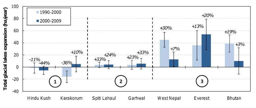
Abstract: In this study, we present a first regional assessment of glacial lake distribution and evolution in the Hindu Kush Himalaya (HKH). Seven sites have been selected between Bhutan and Afghanistan, to capture the climatic variability along the 2000-km long mountain range. For each site, glacial lakes have been mapped with LANDSAT satellite imagery acquired in 1990, 2000 and 2009, using an automatic classification. In the East (India, Nepal and Bhutan), glacial lakes are bigger and more numerous than in the West (Pakistan, Afghanistan), and have grown continuously between 1990 and 2009 by 20% to 65%. On the other hand, during the same period, the glacial lake coverage has shrunk in the Hindu Kush (−50%) and the Karakorum (−30%). This east/west pattern of lake changes seems in agreement with sparse glaciological measurements that suggest less (or even no) ice loss in the western part of the HKH.

Summary (3 min read)

1. Introduction

  • The distribution and the temporal evolution of glacial lakes over the entire HKH range have never been addressed yet.
  • As suggested by Kargel et al. (2005) , glacier and glacial lake evolution are likely to be very different between the eastern part of the mountain range where the large majority of glaciers are retreating and the western part where glacier changes are slower.
  • The purpose of this paper is thus to give an overview of the distribution and recent evolution of glacial lakes along the HKH range, from Bhutan to Afghanistan.
  • To achieve this goal, a set of optical satellite images has been used, with a time coverage spreading from 1989 to 2009.

2.1. Study area

  • The HKH region, ranging from Afghanistan to Bhutan, is covered by about 60,000 km² of glaciers (Dyurgerov and Meier, 2005) .
  • The precipitation pattern is characterized by two gradients (Bookhagen and Burbank, 2006) : (i) a north-south gradient due to the orographic barrier, preventing air masses to go further north, (ii) an east-west gradient, due to the weakening westwards of the Indian monsoon coming from the Bay of Bengal, and implying a greater humidity in the eastern HKH.
  • Their locations are presented in Figure 1 .
  • Their extent corresponds to the footprint of a LANDSAT image, i.e. 31110 km².
  • These seven study sites encompass approximatively 24100 km 2 of glaciers, or 40% of the total ice-covered area in the HKH (Table 2 ).

2.2. Data

  • To avoid cloud cover during the monsoon and ensure minimal snow coverage, the authors selected satellite images acquired between September and November (for the eastern part) and between June and October (for the western part).
  • Each of the seven study sites has been observed with two LANDSAT-TM and a LANDSAT-ETM image with a spatial resolution of 30 m (images downloaded from http://glcf.umiacs.umd.edu and http://glovis.usgs.gov).
  • The images were already radiometrically corrected and projected in the UTM coordinate system.
  • Acquisition dates are listed in Table 3 .
  • Temperatures at 600 hPa are used as an indicator of the overall trend in temperatures along the HKH range, whereas temperatures at mean glacial lake altitude are used to interpret glacial lake evolution.

TM ETM TM

  • Precipitations have been analyzed through the Global Precipitation Climatology Project, providing monthly values on a 2.5°x2.5° grid since 1979 (GPCP, Huffman and Bolvin, 2009) .
  • Time series of monthly temperature and precipitation in the middle of each study site during each decade since 1979 were computed using a bilinear interpolation, based on the four surrounding grid points.

3. Methodology

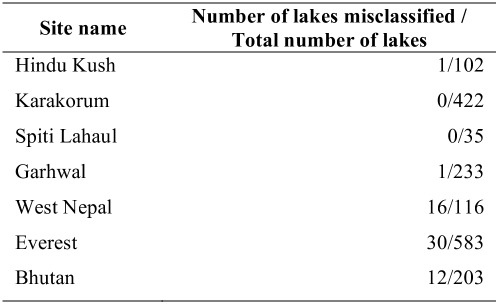
  • Given the lack of ground truth and field measurements, it is difficult to assess the precision and quality of the classifications.
  • (i) the quality of remotely sensed data (directly linked to the sensor quality and resolution), (ii) the precision of the data pre-processing (radiometric and geometric corrections), (iii) the quality of the classification algorithms (type of algorithm, choice of threshold values), also known as It mostly depends on.
  • The error in image co-registration does not play a key role, since comparison is not made pixel by pixel but entity by entity.

4.1. Distribution of glacial lakes over the HKH

  • Another interesting characteristic of glacial lakes is their altitude.
  • In Nepal and Bhutan, lakes are at the same altitude as the glacier termini, since they are in majority pro-glacial and are the exutory of the glacier catchments.
  • Individual lake size also greatly varies from one study site to another (Figure 7 ).
  • Smaller lakes (less than 20 hectares) dominate in the west (in the Hindu Kush, Karakorum, and to a lesser extent in Spiti Lahaul and Garhwal).
  • In Spiti Lahaul, two dis-proportionally large lakes (between 50 and 100 hectares each) located in the northern part of the site represent 70% of the total lake coverage.

4.2. Evolution of glacial lakes during 1990-2009

  • The expansion rate of supra-glacial lakes is always higher than the one of pro-glacial lakes which are not in contact with the glacier termini.
  • On the other hand, pro-glacial lakes in contact with a glacier have a similar (or even higher) expansion rate than supra-glacial lakes.

5.1. Glacial lake inventory by remote sensing

  • The uncertainty of a single glacial lake area has been computed, by assuming that the lake margin is mapped with an error of ± 1 pixel along its perimeter.
  • This uncertainty can be considered as conservative, compared to Fujita et al. (2009) who assumed an error of ± 0.5 pixel along the perimeter of the Imja lake, Everest region (Table 1 in Fujita et al., 2009) .
  • Among the 50 glacial lakes investigated by Komori (2008) , 12 are included in their Bhutan study site.
  • The total difference between the area of those lakes (986 ha) given by Komori (2008) in November and December 2001 and the value of this present study (971 ha) on the 4 th November 2001 is 15 ha, which shows the good coherency of their classification algorithm with former studies.

5.2. Pro-and supra-glacial lake variations

  • In Bhutan, Komori (2008) already investigated growth characteristics of glacial lakes and reported expansion rates for 19 lakes, ranging from 0 to 3.7 ha/y (between 1960s and 2001) .
  • Komori (2008) investigated 19 lakes whereas in this study the mean expansion rates in Bouthan are based on 203 lakes.

5.3. Glacial lake and climate variations

  • Precipitation has been divided into solid and liquid based on a threshold (+2°C, Oerlemans (1993) ) on temperature data.
  • As shown in Table 5 , trends in temperature, solid and liquid precipitations are opposite between the 90s and the 00s in the east (Bhutan, Everest and West Nepal), whereas glacial lakes show a continous expansion among those study sites (Figure 8 ).
  • This suggests that the climate influence on glacial lakes is rather complex and cannot solely account for lake variations.

5.4. Glacial lake and glacier mass balance variations

  • Where glaciers have lost mass, lakes have grown (Garhwal, Spiti Lahaul, Everest), and, in the Karakorum, where glaciers have lost limited mass (Matsuo and Heki, 2010) or surged (Hewitt, 2005; Hewitt, 2007) lakes have shrunk.
  • This analysis cannot be taken any further quantitatively, because study periods of mass balance are short, not homogeneous and a single glacier may not be representative of the evolution of the study site to which it belongs.
  • Furthermore, direct or geodetic mass balance measurements are still lacking for some large regions such as the Hindu Kush and the Karakorum.
  • The SRTM DEM is also available in 2000 although its resolution is coarser.
  • Glacier volume changes can be assessed by subtracting those DEMs between two or more dates (Berthier et al., 2004) .

6. Conclusion

  • This study gave an indirect insight of what happened to the HKH cryosphere over the last 20 years, through glacial lake evolution.
  • The authors work highlights a complex pattern of lake area change, with a strong east-west gradient across the HKH that seems to confirm the general pattern of glacier change.
  • Regionalization of glacier mass balance over the HKH is now critically needed, to better describe the contrasted response of the HKH cryosphere to regional climate changes.

Did you find this useful? Give us your feedback

Figures (14)

Content maybe subject to copyright    Report

HAL Id: hal-00561576
https://hal.archives-ouvertes.fr/hal-00561576
Submitted on 2 Feb 2011
HAL is a multi-disciplinary open access
archive for the deposit and dissemination of sci-
entic research documents, whether they are pub-
lished or not. The documents may come from
teaching and research institutions in France or
abroad, or from public or private research centers.
L’archive ouverte pluridisciplinaire HAL, est
destinée au dépôt et à la diusion de documents
scientiques de niveau recherche, publiés ou non,
émanant des établissements d’enseignement et de
recherche français ou étrangers, des laboratoires
publics ou privés.
Contrasted evolution of glacial lakes along the Hindu
Kush Himalaya mountain range between 1990 and 2009
Julie Gardelle, Y. Arnaud, Etienne Berthier
To cite this version:
Julie Gardelle, Y. Arnaud, Etienne Berthier. Contrasted evolution of glacial lakes along the Hindu
Kush Himalaya mountain range between 1990 and 2009. Global and Planetary Change, Elsevier, 2011,
75 (1-2), pp.47-55. �10.1016/j.gloplacha.2010.10.003�. �hal-00561576�

Contrasted evolution of glacial lakes along the Hindu Kush Himalaya mountain range
between 1990 and 2009.
Julie Gardelle
a*
, Yves Arnaud
a,b
, Etienne Berthier
c
*Corresponding author: julie.gardelle@lgge.obs.ujf-grenoble.fr. Tel.: +33 4 76 82 42 06.
a
Laboratoire de Glaciologie et Géophysique de l’Environnement, CNRS, UJF-Grenoble, 54 rue Molière, BP
96, 38402 Saint Martin d’Hères, France.
b
Laboratoire d’études des Transferts en Hydrologie et Environnement, IRD, 1023 rue de la Piscine, BP 53,
38401 Grenoble Cedex 09, France.
c
CNRS; Université de Toulouse ; LEGOS; 14 Av. Ed. Belin, 31400 Toulouse, France
Citation: Julie Gardelle, Yves Arnaud, Etienne Berthier, Contrasted evolution of glacial lakes along the Hindu Kush
Himalaya mountain range between 1990 and 2009, Global and Planetary Change, Volume 75, Issues 1-2, January
2011, Pages 47-55, DOI: 10.1016/j.gloplacha.2010.10.003
Abstract
In this study, we present a first regional assessment of glacial lake distribution and evolution in the Hindu
Kush Himalaya (HKH). Seven sites have been selected between Bhutan and Afghanistan, to capture the
climatic variability along the 2000-km long mountain range. For each site, glacial lakes have been mapped
with LANDSAT satellite imagery acquired in 1990, 2000 and 2009, using an automatic classification. In the
East (India, Nepal and Bhutan), glacial lakes are bigger and more numerous than in the West (Pakistan,
Afghanistan), and have grown continuously between 1990 and 2009 by 20% to 65%. On the other hand,
during the same period, the glacial lake coverage has shrunk in the Hindu Kush (-50%) and the Karakorum (-
30%). This east/west pattern of lake changes seems in agreement with sparse glaciological measurements
that suggest less (or even no) ice loss in the western part of the HKH.
Keywords: Glacial lakes, Himalaya, Remote sensing
1. Introduction
Little is currently known about the distribution and evolution of glacial lakes in the vast Hindu Kush
Himalaya (HKH) mountain range although those lakes are potentially an indirect indicator of glacier change
and, in certain cases, threaten the life of the inhabitants of the mountain valleys (Richardson and Reynolds,
2000).
Two types of glacial lakes can be distinguished: (i) pro-glacial lakes, often growing downstream of steep
glaciers, where water is collected behind former moraines (Richardson and Reynolds, 2000; Komori, 2008);
(ii) supra-glacial lakes, which develop on the surface of the glacier itself, growing by coalescence of small
ponds. They tend to develop on long, flat, debris-covered valley glaciers which respond to a negative mass
balance by thinning (downwasting) rather than by a terminus retreat (Reynolds, 2000; Richardson and
Reynolds, 2000; Quincey et al., 2007; Komori, 2008).
Recent expansion of glacial lakes in the Himalaya has mainly been studied in north Bhutan (Fujita et al.,
2008; Komori, 2008) and in the Everest region (Yamada and Sharma, 1993; Sakai et al., 2000; Benn et al.,
2001; Wessels et al., 2002; Bolch et al., 2008a). However, the distribution and the temporal evolution of
glacial lakes over the entire HKH range have never been addressed yet. As suggested by Kargel et al. (2005),
glacier and glacial lake evolution are likely to be very different between the eastern part of the mountain
range where the large majority of glaciers are retreating and the western part where glacier changes are
slower. The purpose of this paper is thus to give an overview of the distribution and recent evolution of

glacial lakes along the HKH range, from Bhutan to Afghanistan. To achieve this goal, a set of optical
satellite images has been used, with a time coverage spreading from 1989 to 2009.
2. Study area and data
2.1. Study area
The HKH region, ranging from Afghanistan to Bhutan, is covered by about 60,000 km² of glaciers
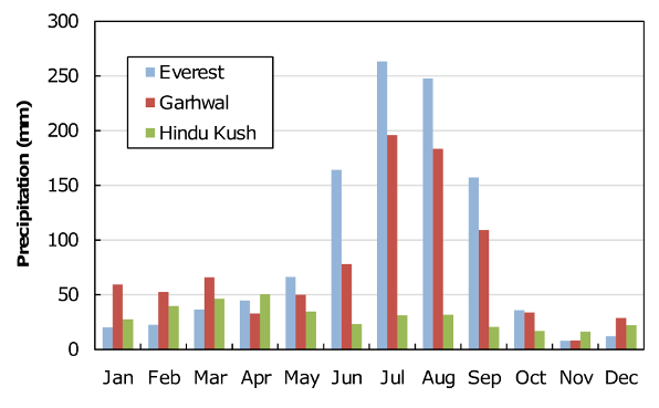
(Dyurgerov and Meier, 2005). Precipitation regimes are driven by the Indian monsoon in summer
(precipitation occurring from June to September) and by the mid-latitude westerlies in winter (precipitation
occurring from January to April) (Böhner, 2006). The precipitation pattern is characterized by two gradients
(Bookhagen and Burbank, 2006): (i) a north-south gradient due to the orographic barrier, preventing air
masses to go further north, (ii) an east-west gradient, due to the weakening westwards of the Indian monsoon
coming from the Bay of Bengal, and implying a greater humidity in the eastern HKH.
Figure 1: Location of the seven study sites along the HKH range (their names appear in bold on the map). For each
site, the footprint of a LANDSAT image is shown. Ice covered areas are represented by blue filled polygons.
In order to study glacial lakes over the HKH region, seven study sites (comprising a high proportion of
glaciarized area) have been selected along the mountain range, so as to be representative of the climatic
gradients (Table 1). Their locations are presented in Figure 1. Their extent corresponds to the footprint of a
LANDSAT image, i.e. 31110 km². These seven study sites encompass approximatively 24100 km
2
of
glaciers, or 40% of the total ice-covered area in the HKH (Table 2). Bhutan, Everest and West Nepal sites
are directly influenced by the Indian monsoon, summer being both ablation and accumulation seasons on
glaciers (Fujita, 2008). Western sites, namely Hindu Kush and Karakorum, are much dryer, with
precipitation occurring mainly during winter. Between these two extreme parts of the HKH region, the Spiti
Lahaul and Garhwal sites represent a transition zone, influenced by both the summer monsoon and the winter
westerlies (Figure 2).

Mean annual temperature (°C)
Site name
at 600hPa
at mean glacial lake altitude
Mean annual
precipitation (m)
-0.2
-3.7
1.03
-0.2
-5.5
1.04
-1.2
-6.9
0.91
-1.7
-4.5
0.87
-2.4
-2.5
0.86
-3.7
-3.3
0.30
-4.5
-0.8
0.35
Table 1: Climate characteristics of the seven study sites (temperatures at 600hPa and interpolated between two
pressure levels at the mean lake altitude from NCEP/DOE-Reanalysis 2, precipitation from Global Precipitation
Climatology Project).
Site name
Glacier
area (km²)
Glacier mean
altitude (m)
Front mean
altitude (m)
Lake mean
altitude (m)
Number
of lakes
Total lake
area (km²)
Bhutan
1510
5600
4836
4814
203
27.2
Everest
2919
5614
5084
5079
583
29.1
West Nepal
960
5431
5128
5117
116
16.6
Garhwal
3910
5337
4278
4683
233
2.2
Spiti Lahaul
2854
5091
4129
4209
35
1.9
Karakorum
8718
5153
3609
4129
422
3.7
Hindu-Kush
3229
4617
3206
3622
102
0.7
Table 2: Glaciers and lakes characteristics of the seven study sites. A LANDSAT scene covers in total ~31110 km², but
on each site, only the part of the scene covered with glaciers has been analyzed.
Figure 2: Monthly precipitations from Global Precipitation Climatology Project for three study sites: Everest, Garhwal
and Hindu Kush.
2.2. Data
To avoid cloud cover during the monsoon and ensure minimal snow coverage, we selected satellite images
acquired between September and November (for the eastern part) and between June and October (for the
western part). Each of the seven study sites has been observed with two LANDSAT-TM and a LANDSAT-
ETM image with a spatial resolution of 30 m (images downloaded from http://glcf.umiacs.umd.edu and

http://glovis.usgs.gov). The images were already radiometrically corrected and projected in the UTM
coordinate system. Acquisition dates are listed in Table 3.
Site name
LANDSAT
TM
ETM
TM
Bhutan
14/11/1990
04/11/2001
17/10/2009
Everest
17/11/1992
30/10/2000
31/10/2009
West Nepal
21/10/1992
03/10/2000
18/09/2009
Garhwal
15/11/1990
15/10/1999
12/06/2009
Spiti Lahaul
09/10/1989
15/10/2000
01/11/2009
Karakorum
29/06/1990
12/10/2002
21/09/2009
Hindu-Kush
26/07/1989
16/09/1999
19/09/2009
Table 3: Dates (format is DD/MM/YYYY) of the images used in this study.
For each study site, a digital elevation model (DEM) of 2000 from the SRTM (Shuttle Radar Topography
Mission) has also been downloaded at http://srtm.csi.cgiar.org/, with a spatial resolution of 90 m.
Glacier inventories have been obtained from the GLIMS (Global Land Ice Measurements from Space, Raup
et al., 2007) and ICIMOD (International Center for Integrated Mountain Development, ICIMOD, 2007)
databases, which provide glacier outlines associated with various attributes, such as glacier length, area and
orientation.
Finally, to analyze climate variability along the HKH, monthly air temperatures at 600 hPa and at the lake
altitude were extracted from NCEP/DOE (National Centers for Environmental Prediction/Department of
Energy) reanalysis-2 data on a 2.5°x2.grid (Kanamitsu et al., 2002) since 1979. Temperatures at 600 hPa
are used as an indicator of the overall trend in temperatures along the HKH range, whereas temperatures at
mean glacial lake altitude are used to interpret glacial lake evolution. The latter are computed by
interpolating temperature data between two pressure levels enclosing the mean glacial lake altitude.
Precipitations have been analyzed through the Global Precipitation Climatology Project, providing monthly
values on a 2.5°x2.5° grid since 1979 (GPCP, Huffman and Bolvin, 2009). Time series of monthly
temperature and precipitation in the middle of each study site during each decade since 1979 were computed
using a bilinear interpolation, based on the four surrounding grid points.
3. Methodology
Others authors previously addressed the question of mapping glacier lakes from multispectral satellite
imagery. Wessels et al. (2002) performed a spectral analysis of terrain features in the Mount Everest region
based on ASTER imagery, outlining the importance of water turbidity when monitoring glacial lakes. A
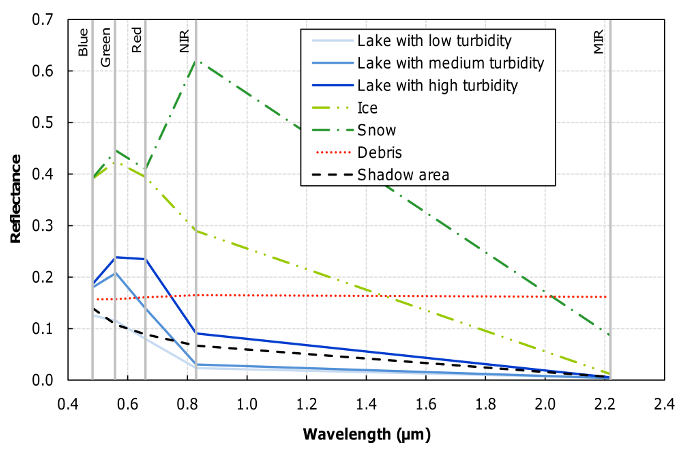
similar spectral analysis has been carried out with one of our LANDSAT scene (Figure 3). The more turbid a
glacial lake is, the higher its reflectance in the Visible and Near Infra-Red (VNIR) is, mainly because of the
high suspended sediment load. As we are considering optical images, shadowing is problematic, especially in
mountainous area when the solar zenith angle is high. It is important to notice that the spectral signature of
these shadow areas (black line in Figure 3) is very similar to the one of glacial lakes with low turbidity.
Wessels et al. (2002) also discussed the automatic classification of glacial lakes. Using the four bands in the
VNIR and MIR (Middle Infra-Red) of ASTER data, they computed two ratios to distinguish (i) water
surfaces from non-water surfaces, with ratio R
1
(Equation 1) (ii) solid (ice or snow) from liquid (free water)
surface, among classified water surfaces, with ratio R
2
(Equation 2).
(1)

Citations
More filters
Journal ArticleDOI
20 Apr 2012-Science
TL;DR: The contemporary evolution of glaciers in the Himalayan region is reviewed, including those of the less well sampled region of the Karakoram to the Northwest, in order to provide a current, comprehensive picture of how they are changing.
Abstract: Himalayan glaciers are a focus of public and scientific debate. Prevailing uncertainties are of major concern because some projections of their future have serious implications for water resources. Most Himalayan glaciers are losing mass at rates similar to glaciers elsewhere, except for emerging indications of stability or mass gain in the Karakoram. A poor understanding of the processes affecting them, combined with the diversity of climatic conditions and the extremes of topographical relief within the region, makes projections speculative. Nevertheless, it is unlikely that dramatic changes in total runoff will occur soon, although continuing shrinkage outside the Karakoram will increase the seasonality of runoff, affect irrigation and hydropower, and alter hazards.

1,561 citations

Journal ArticleDOI
23 Aug 2012-Nature
TL;DR: Satellite laser altimetry and a global elevation model are used to show widespread glacier wastage in the eastern, central and south-western parts of the HKKH during 2003–08 and show indirect evidence of a complex pattern of glacial responses in reaction to heterogeneous climate change signals.
Abstract: Glaciers are among the best terrestrial climate indicators, an important water resource in mountains1,2 and a major contributor to global sea level rise3,4. In the Hindu Kush - Karakoram - Himalaya region (HKKH), a paucity of appropriate glacier data has prevented a comprehensive assessment of current regional mass balance5. However, there are indirect evidences of a complex pattern of glacial responses5-8 in reaction to heterogeneous climate change signals9. Here, we provide the first coherent data set of detailed glacier thickness changes over the HKKH during 2003-2009 by combining satellite laser altimetry and a global elevation model. In the eastern, central and south-western parts of the HKKH, glacier wastage is widespread with regional thinning rates up to 0.66 ± 0.09 m a-1 in the Jammu-Kashmir region. Conversely, in the Karakoram, glaciers are close to balance with only a slight thinning of 0.07 ± 0.04 m a-1. Regionally averaged thinning rates under debris-mantled ice are similar to those of clean ice despite insulation by debris covers. The 2003-2008 specific mass balance for our HKKH study region is -0.21 ± 0.05 m a-1 water equivalent (WE), significantly less negative than the global average of ~ -0.7 m a-1 WE for glaciers and ice caps4,10. This difference is mainly an effect of the balanced glacier mass budget in the Karakoram. The corresponding HKKH sea level contribution is +0.035 ± 0.009 mm a-1 amounting to 1% of the present-day sea level rise11. Our 2003-2008 mass budget of -12.8 ± 3.5 Gt a-1 is more negative than recent satellite gravimetry based estimates of -5 ± 6 Gt a-1 over 2003-2010 (ref. 12). For the mountain catchments of the Indus and Ganges basins13, the glacier imbalance contributes ~3.5% and ~2.0%, respectively, to the annual average river discharge13, and up to ~10% for the Upper Indus basin14.

961 citations

Journal ArticleDOI
TL;DR: In this paper, the authors compared the 2000 Shuttle Radar Topography Mission (SRTM) digital elevation model (DEM) to recent (2008-2011) DEMs derived from SPOT5 stereo imagery.
Abstract: The recent evolution of Pamir-Karakoram-Himalaya (PKH) glaciers, widely acknowledged as valuable high-altitude as well as mid-latitude climatic indicators, remains poorly known. To estimate the region-wide glacier mass balance for 9 study sites spread from the Pamir to the Hengduan Shan (eastern Himalaya), we compared the 2000 Shuttle Radar Topography Mission (SRTM) digital elevation model (DEM) to recent (2008-2011) DEMs derived from SPOT5 stereo imagery. During the last decade, the region-wide glacier mass balances were contrasted with moderate mass losses in the eastern and central Himalaya (-0.22 ± 0.12 m w.e./yr to -0.33 ± 0.14 m w.e./yr) and larger losses in the western Himalaya (-0.45 ± 0.13 m w.e./yr). Recently reported slight mass gain or balanced mass budget of glaciers in the central Karakoram is confirmed for a larger area (+0.10 ± 0.16 m w.e./yr) and also observed for glaciers in the western Pamir (+0.14 ± 0.13 m w.e./yr). Thus, the "Karakoram anomaly" should be renamed the "Pamir-Karakoram anomaly", at least for the last decade. The overall mass balance of PKH glaciers, -0.14 ± 0.08 m w.e./yr, is two to three times less negative than the global average for glaciers distinct from the Greenland and Antarctic ice sheets. Together with recent studies using ICESat and GRACE data, DEM differencing confirms a contrasted pattern of glacier mass change in the PKH during the first decade of the 21st century.

715 citations

Journal ArticleDOI
TL;DR: In this article, the authors analyzed a series of catastrophic slope failures that occurred in the mountains of Europe, the Americas, and the Caucasus since the end of the 1990s, and proposed that the following mechanisms can significantly alter landslide magnitude and frequency, and thus hazard, under warming conditions: (1) positive feedbacks acting on mass movement processes that after an initial climatic stimulus may evolve independently of climate change; (2) threshold behavior and tipping points in geomorphic systems; (3) storage of sediment and ice involving important lag-time effects.
Abstract: Climate change, manifested by an increase in mean, minimum, and maximum temperatures and by more intense rainstorms, is becoming more evident in many regions. An important consequence of these changes may be an increase in landslides in high mountains. More research, however, is necessary to detect changes in landslide magnitude and frequency related to contemporary climate, particularly in alpine regions hosting glaciers, permafrost, and snow. These regions not only are sensitive to changes in both temperature and precipitation, but are also areas in which landslides are ubiquitous even under a stable climate. We analyze a series of catastrophic slope failures that occurred in the mountains of Europe, the Americas, and the Caucasus since the end of the 1990s. We distinguish between rock and ice avalanches, debris flows from de-glaciated areas, and landslides that involve dynamic interactions with glacial and river processes. Analysis of these events indicates several important controls on slope stability in high mountains, including: the non-linear response of firn and ice to warming; three-dimensional warming of subsurface bedrock and its relation to site geology; de-glaciation accompanied by exposure of new sediment; and combined short-term effects of precipitation and temperature. Based on several case studies, we propose that the following mechanisms can significantly alter landslide magnitude and frequency, and thus hazard, under warming conditions: (1) positive feedbacks acting on mass movement processes that after an initial climatic stimulus may evolve independently of climate change; (2) threshold behavior and tipping points in geomorphic systems; (3) storage of sediment and ice involving important lag-time effects.

315 citations

Journal ArticleDOI
TL;DR: Proglacial lakes are ubiquitous within the Quaternary record and can provide exceptional breadth and depth of palaeoenvironmental information as discussed by the authors, and the importance of proglacial lakes from a geological perspective.

275 citations

References
More filters
Journal ArticleDOI
TL;DR: The NCEP/NCAR 40-yr reanalysis uses a frozen state-of-the-art global data assimilation system and a database as complete as possible, except that the horizontal resolution is T62 (about 210 km) as discussed by the authors.
Abstract: The NCEP and NCAR are cooperating in a project (denoted “reanalysis”) to produce a 40-year record of global analyses of atmospheric fields in support of the needs of the research and climate monitoring communities. This effort involves the recovery of land surface, ship, rawinsonde, pibal, aircraft, satellite, and other data; quality controlling and assimilating these data with a data assimilation system that is kept unchanged over the reanalysis period 1957–96. This eliminates perceived climate jumps associated with changes in the data assimilation system. The NCEP/NCAR 40-yr reanalysis uses a frozen state-of-the-art global data assimilation system and a database as complete as possible. The data assimilation and the model used are identical to the global system implemented operationally at the NCEP on 11 January 1995, except that the horizontal resolution is T62 (about 210 km). The database has been enhanced with many sources of observations not available in real time for operations, provided b...

28,145 citations

Journal ArticleDOI
TL;DR: The NCEP-DOE Atmospheric Model Intercomparison Project (AMIP-II) reanalysis is a follow-on project to the "50-year" (1948-present) N CEP-NCAR Reanalysis Project.
Abstract: The NCEP–DOE Atmospheric Model Intercomparison Project (AMIP-II) reanalysis is a follow-on project to the “50-year” (1948–present) NCEP–NCAR Reanalysis Project. NCEP–DOE AMIP-II re-analysis covers the “20-year” satellite period of 1979 to the present and uses an updated forecast model, updated data assimilation system, improved diagnostic outputs, and fixes for the known processing problems of the NCEP–NCAR reanalysis. Only minor differences are found in the primary analysis variables such as free atmospheric geopotential height and winds in the Northern Hemisphere extratropics, while significant improvements upon NCEP–NCAR reanalysis are made in land surface parameters and land–ocean fluxes. This analysis can be used as a supplement to the NCEP–NCAR reanalysis especially where the original analysis has problems. The differences between the two analyses also provide a measure of uncertainty in current analyses.

5,177 citations

Journal ArticleDOI
Regine Hock1
TL;DR: In this paper, the authors provide an overview of temperature-index methods, including glacier environments, and discuss recent advances on distributed approaches attempting to account for topographic effects in complex terrain, while retaining scarcity of data input.

1,243 citations

Journal ArticleDOI
TL;DR: In this paper, the number and volume of potentially hazardous moraine-dammed lakes in the Himalayas is increasing, and these lakes develop behind unstable ice-cored moraines, and have the potential to burst catastrophically, producing devastating Glacial Lake Outburst Floods (GLOFs).

763 citations

Journal ArticleDOI
TL;DR: In the late 1990s widespread evidence of glacier expansion was found in the central Karakoram, in contrast to a worldwide decline of mountain glaciers as mentioned in this paper, and the expansions were almost exclusively in glacier basins from the highest parts of the range and developed quickly after decades of decline.
Abstract: In the late 1990s widespread evidence of glacier expansion was found in the central Karakoram, in contrast to a worldwide decline of mountain glaciers. The expansions were almost exclusively in glacier basins from the highest parts of the range and developed quickly after decades of decline. Exceptional numbers of glacier surges were also reported. Unfortunately, there has been no on-going measurement of climatic or glaciological variables at these elevations. The present article examines possible explanations for this seemingly anomalous behavior, using evidence from short-term monitoring programs, low-altitude weather stations, and the distinctive environmental characteristics of the region. The latter involve interactions between regional air mass climatology, its seasonality, topoclimate or ‘verticality’ effects on glaciers with extreme altitudinal range, climatic sensitivities of heavy versus thin supraglacial debris, and complex temperature distributions in ice masses with ice falls through...

672 citations

Frequently Asked Questions (1)
Q1. What are the contributions in "Contrasted evolution of glacial lakes along the hindu kush himalaya mountain range between 1990 and 2009" ?

In this study, the authors present a first regional assessment of glacial lake distribution and evolution in the Hindu Kush Himalaya ( HKH ). This east/west pattern of lake changes seems in agreement with sparse glaciological measurements that suggest less ( or even no ) ice loss in the western part of the HKH.