scispace - formally typeset
Open AccessJournal ArticleDOI

Evacuation Route Selection Based on Tree-Based Hazards Using Light Detection and Ranging and GIS

Reads0
Chats0
TLDR
A novel methodology for automating the tree threat identification process by using airborne laser altimetry data and a geographical information system (GIS) has the potential to be used for selecting the best possible evacuation routes based on tree hazards.
Abstract:Ā 
Falling trees pose a great hazard to the safe and uninterrupted use of the road transportation system during storm events. The present process of manually identifying potentially hazardous trees is laborious and inefficient. This paper presents a novel methodology for automating the tree threat identification process by using airborne laser altimetry data and a geographical information system (GIS). This methodology has the potential to be used for selecting the best possible evacuation routes based on tree hazards. The proposed method harnesses the power of spatial analysis functionality provided by existing GIS software and high-quality, three-dimensional (3D) data obtained from an airborne laser scanning system. This paper highlights the benefits related to using: (1) Height calculation of tall objects; (2) identification of hazardous objects; and (3) object identification from irregular 3D light detection and ranging point data over the currently employed manual methods.

read more

Content maybe subject toĀ copyrightĀ Ā Ā  Report

Provided by the author(s) and University College Dublin Library in accordance with publisher
policies. Please cite the published version when available.
Title Evacuation route selection based on tree-based hazards using LiDar and GIS
Authors(s) Laefer, Debra F.; Pradhan, Anu
Publication date 2006-04
Publication information Journal of Transportation Engineering, 132 (4): 312-320, Technical papers
Publisher American Society of Civil Engineering (ASCE)
Link to online version http://dx.doi.org/10.1061/(ASCE)0733-947X(2006)132:4(312)
Item record/more information http://hdl.handle.net/10197/2307
Publisher's version (DOI) 10.1061/(ASCE)0733-947X(2006)132:4(312)
Downloaded 2022-08-10T07:51:54Z
The UCD community has made this article openly available. Please share how this access
benefits you. Your story matters! (@ucd_oa)
Ā© Some rights reserved. For more information, please see the item record link above.

1
Evacuation Route Selection Based on Tree-Based
Hazards Using LiDAR and GIS
Debra F. Laefer,
1
M. ASCE and Anu R. Pradhan
2
ABSTRACT
Falling trees pose a great hazard to the safe and uninterrupted use of the road transportation system, during storm
events. The present process of manually identifying potentially hazardous trees is laborious and inefficient. This
paper presents a novel methodology for automating the tree threat identification process by using airborne laser
altimetry data and a Geographical Information System (GIS). This methodology has the potential to be used for
selecting the best possible evacuation routes based on tree hazards. The proposed method harnesses the power of
spatial analysis functionality provided by existing GIS software and high-quality, three-dimensional (3D) data
obtained from an airborne laser scanning system. This paper highlights the benefits related to using (a) height
calculation of tall objects, (b) identification of hazardous objects, and (c) object identification from irregular 3D
Light Detection And Ranging (LiDAR) point data over the currently employed manual methods.
KEYWORDS: Geographic Information Systems, Roadside Hazards, Highway Maintenance, Trees,
Transportation Management, Highway Safety, Lasers, Evacuation
1
Lecturer, Department of Civil Engineering, University College Dublin, Earlsfort Terrace, Room 115, Dublin 2, Ireland. Email:
debra.laefer@ucd.ie
2
Graduate Research Assistant, Department of Civil and Environmental Engineering, PH 119, Carnegie Mellon University, Pittsburgh, PA. Email:
arpradha@andrew.cmu.edu

2
INTRODUCTION
Wooded areas flank the primary and secondary road networks in many states. During severe weather incidents,
fallen trees knock down power lines, endanger telephone lines, and block roadways. Besides disrupting traffic flow,
such incidents endanger the lives of drivers and emergency crews, hinder service restoration, and impede effective
emergency response. To avoid this, trees that may be a threat should be identified, and measures should be
considered to prevent them from falling on overhead lines and thoroughfares. Before preventive measures can be
considered, however, these trees must be identified. A manual approach to such a problem is not viable, because of
the time and resources necessary for the initial assessment and the need for periodic updates. New technologies offer
the possibility of automating such an identification process. With advances in Geographical Information System
(GIS) and Remote Sensing (RS), an automated hazard identification tool can be developed for the aforementioned
problem that is more economical, efficient, reliable, and safer than a manual approach. The ideal application of such
an evaluation is in the selection of the most reliable evacuation routes. The goal of this research is to describe the
development of such algorithms and the resources necessary to automate identification of trees that may endanger
transportation routes.
BACKGROUND
Hurricanes, other strong winds, and ice storms cause tremendous damage across the United States (US) including
flooding, wind-based destruction of property, and blockage of major road networks from fallen objects. The direct
cost of such incidents can be in the billions of dollars, as was the case with hurricane Floyd in 1999 in eastern North
Carolina ($5.45 billion in damage costs) [Herbert et al. 1997], as well as indirect costs for economic losses due to
closed businesses and lost productivity. The blockage of roads due to fallen trees and utility lines during severe
weather is a significant problem (Draper 2003). According to the North Carolina Division of Emergency
Management, after hurricane Isabel, Bertie County alone required tree debris removal from all roads in the county
except three, totaling 780 km of road from which 52,865 cubic meter or 43,245.27 kg of debris was removed, at a
cost of $1.6 million, over the course of 84 days (Canty 2004). Beyond economics, posing a great risk to motorists,
and interfering with utility service, roadway obstacles also disrupt traffic flow, and thus hamper evacuation and
rescue operations.

3
The problem of tree-based hazards is well recognized, and each year millions of dollars are spent annually to
identify and cut or trim such trees (Act 2003). In most states, identification of potentially hazardous tall objects has,
to date, been done manually by road crews on an ad hoc basis. The task is significant. In North Carolina (NC) alone,
there are 125,580 km of state maintained roads, not including 34,680 km of county and city roads (NC-DOT 2003)
covering an area of 136,523 km
2
(State Library of NC 2004). Across the US, the national interstate system alone is
comprised of 75,150 km of highway (FHWA 2003). As such, a manual approach to hazardous tree identification is
cost prohibitive as well as time-consuming, especially since the effort would require periodic updates because of tree
growth and road expansion. Thus, an automated process that is fast and potentially cost-effective, during initial
identification and later updating, is critically needed.
At the most elementary level, for an automated tool to be effective it should be able to (a) identify the roads of
interest, (b) locate tall objects, (c) calculate the heights of potentially hazardous objects along the roads, and (d)
compare the height of the object to its distance from the roadway. The success of such an automated tool depends on
both the quality of available data and a robust application that analyzes and processes the given data. As highly
detailed data must be collected along the entire length of road network, data gathering becomes the most time-
consuming and expensive part of the process. Light Detection And Ranging (LiDAR), a recent advancement in RS
technologies, offers the potential of automated and expeditious data collection, and GIS provides a means to analyze
and process such data.
LiDAR and Its Characteristics
LiDAR is an active remote sensing technology that is used to collect topographic data (NOAA 2003). The data are
collected with aircraft-mounted lasers capable of recording elevation measurements at a rate of 5,000 to 50,000
pulses per second. The difference in time is measured from when a laser pulse is emitted from a sensor to when the
target objects in the path of the laser reflect back the pulse. Using the speed of light, these time measurements can be
converted into distance or range (Lim et al. 2001). The LiDAR instruments collect elevation data. To make these
data spatially relevant, the positions of the data points must be known. Thus, a high-precision global positioning
system (GPS) antenna, mounted on the aircraft, is used to determine the spatial positions of the data points. The end

4
product is accurate, geographically registered longitude, latitude, and elevation from the mean sea level (x, y, z)
positions for every data point (Baltsavias 1999). Latitude, longitude, and elevation are typically presented in a plane
co-ordinate system.
LiDAR is capable of providing both horizontal and vertical information at high spatial resolutions and vertical
accuracies. Airborne-based LiDAR data are accurate to +/-15 cm for vertical measurements and +/- 1.5 m (worst
case scenario) for horizontal distances (Flood 1999), although the system is marketed as having an accuracy of an
order of magnitude better in both directions (ALTM 2003). The extent of LiDAR point density is dependent on
flying height and system dependent factors such as platform velocity, sampling frequency, and field of view
(Axelsson 1999). The point density needs to be adjusted according to the application so that sufficient information is
harvested, while not collecting excessively detailed data. LiDAR technology has been used in many areas of
applications such as (a) generation for a variety of GIS/mapping related products, (b) forestry, (c) coastal
engineering, (d) flood plain mapping, (e) disaster response and damage assessment, and (f) urban modeling
(Airbornelasermapping 2003).
A current limitation of LiDAR is that it does not store any topological, shape, or size information of the
geographical features scanned. A LiDAR dataset is simply a collection of somewhat randomly distributed 3D points.
As it does not provide feature information, clever and efficient algorithms are required for feature identification
depending upon the desired application. Identification of tree hazards requires such an algorithm. LiDAR provides
only qualitative data, thus software capable of analysis is also required. GIS possesses such capabilities.
GIS and Its Characteristics
GIS can be defined as a computer-based tool set for collecting, storing, retrieving, transforming, and displaying
spatial data from a discipline-specific domain for a particular set of purposes (Burrough and McDonnell 1998).
Although computer aided design (CAD) software can perform similar functions, the true strength of GIS lies not its
ability to store and process data but in its spatial representation and spatial analysis (Rasdorf et al. 2000). Spatial
analysis involves examining the geographic patterns in data and observing relationships between geographical

Citations
More filters
Journal ArticleDOI

Spatial comparison between densely built-up districts from the viewpoint of vulnerability to road blockades with respect to evacuation behavior

TL;DR: This study used building properties and Japan Engineering Geomorphologic Classification Map to calculate building collapse risk as a relative value, and applied the road blockade risk as probability to the Monte Carlo simulation for making road blockade patterns.
Proceedings ArticleDOI

Formalized Approach for Accurate Geometry Capture through Laser Scanning

TL;DR: Investigating and formalizing how laser scanning technology can optimally be leveraged and integrated to provide a sufficiently accurate documentation of bridge geometry and then how such information may be transformed into a reliable finite element model for predictive modeling is focused on.
Dissertation

Spatial data storage and processing strategies for urban laser scanning

Anh-Vu Vo
TL;DR: Li et al. as mentioned in this paper proposed a hybrid spatial indexing strategy, which combines a two-dimensional indexing structure at a global level and multiple, in-memory three-dimensional indices at a local level so that the entire index adapts to the typical spatial distribution of urban LiDAR datasets.

Considerations for a District-Level, Tunnel-Risk, Screening Tool

TL;DR: ITA-AITES World Tunneling Congress (WTC 2016) as mentioned in this paper, San Francisco, California, USA, 22-28 April 2016, 22: 28 April 2016
References
More filters
Book

Geographic Information Systems and Science

TL;DR: The Third Edition of this bestselling textbook has been fully revised and updated to include the latest developments in the field and still retains its accessible format to appeal to a broad range of students.
Journal ArticleDOI

Airborne laser scanning: basic relations and formulas

TL;DR: An overview of basic relations and formulas concerning airborne laser scanning is given and a separate discussion is devoted to the accuracy of 3D positioning and the factors influencing it.
Journal ArticleDOI

Processing of laser scanner data-algorithms and applications

TL;DR: This paper presents some methods and algorithms concerning filtering for determining the ground surface, DEM, classification of buildings for 3D City Models and the detection of electrical power lines.
Journal ArticleDOI

Two algorithms for extracting building models from raw laser altimetry data

TL;DR: Two new techniques for the determination of building models from laser altimetry data are presented, both of which work on the original laser scanner data points without the requirement of an interpolation to a regular grid.
Journal ArticleDOI

Extraction of buildings and trees in urban environments

TL;DR: Two methods for data collection in urban environments are presented and the first combines multispectral imagery and laser altimeter data in an integrated classification for the extraction of buildings, trees and grass-covered areas.
Related Papers (5)
Frequently Asked Questions (10)
Q1. What are the contributions mentioned in the paper "Evacuation route selection based on tree-based hazards using lidar and gis" ?

This paper presents a novel methodology for automating the tree threat identification process by using airborne laser altimetry data and a Geographical Informat ion System ( GIS ).Ā The proposed method harnesses the power of spatial analysis functionality provided by existing GIS software and high-quality, three-dimensional ( 3D ) data obtained from an airborne laser scanning system.Ā This paper highlights the benefits related to using ( a ) height calculation of tall objects, ( b ) identification of hazardous objects, and ( c ) object identification from irregular 3D Light Detection And Ranging ( LiDAR ) point data over the currently employed manual methods.Ā Th is methodology has the potential to be used for selecting the best possible evacuation routes based on tree hazards.Ā 

other strong winds, and ice storms cause tremendous damage across the United States (US) including flooding, wind-based destruction of property, and blockage of major road networks from fallen objects.Ā 

GIS can be defined as a computer-based tool set for collecting, storing, retriev ing, transforming, and displaying spatial data from a discipline-specific domain for a particular set of purposes (Burrough and McDonnell 1998).Ā 

Airborne LiDAR systems are capable of producing extremely detailed informat ion of even small scanned areas (Baltsavias 1999), but to achieve a high level of detail requires substantial processing time.Ā 

According to the North Carolina Division of Emergency Management, after hurricane Isabel, Bert ie County alone required tree debris removal from all roads in the county except three, totaling 780 km of road from which 52,865 cubic meter or 43,245.27 kg of debris was removed, at a cost of $1.6 million, over the course of 84 days (Canty 2004).Ā 

The main objective of all of the aforementioned algorithms is to extract features, especially those related to geometry, from the LiDAR points.Ā 

An effective measure to counter such resource intensiveness, while not losing the desired level of detail, is to reduce the dataset size.Ā 

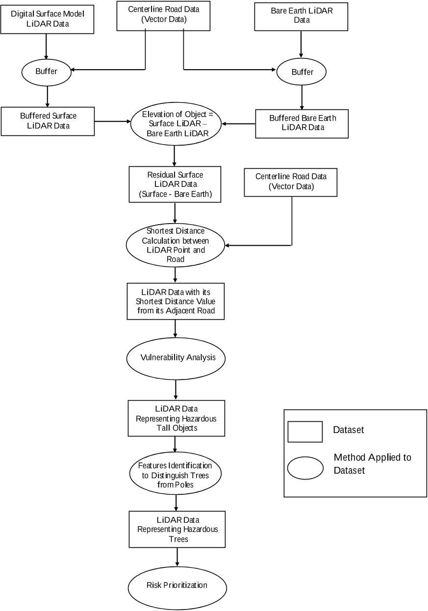
After the height calculation is completed, the shortest distances between the LiDAR points (within the buffer zone) and their adjoining road are calculated by subtracting half the road distance from the centerline position location(Table 2).Ā 

Because of budget restrictions, across the US there is no generalized, method to identify hazardous trees, despite the acknowledged expenses that they generate.Ā 

In this simple example, the number of data points was reduced by 83%, which decreased computation time by 67% compared to the time needed to process the non-buffered data.Ā