scispace - formally typeset
Search or ask a question
Journal ArticleDOI

Evidence of Neolithic settlement in the foothills of the Western al-Hajar Mountains

TL;DR: In addition to surface scatters of lithic artefacts, excavation at the site of Hayy al-Sarh recovered two stratified archaeological horizons (AHs) containing pierced marine shells that provided an age of about 6800 to 7500 years cal BP.
Abstract: Systematic prospection and excavations in the Rustaq region of northern Oman, approximately 45 km from the coast in the foothills of the Western Hajar Mountains, have revealed an unexpectedly dense record of Neolithic sites. Besides surface scatters of lithic artefacts, excavation at the site of Hayy al‐Sarh recovered two stratified archaeological horizons (AHs). The upper horizon, AH I, contained pierced marine shells that provided an age of the archaeological material of about 6800 to 7500 years cal BP. Typologically the AH I lithic assemblage compares to the Suwayh facies defined at the coast 300 km to the east. Whether the marine shells and cultural affinities point towards exchange with coastal communities or possibly seasonal movement remains an open question at this state of research, but this new evidence for inland Neolithic settlement near Rustaq provides important new data that will help improve our understanding of spatial patterns of Neolithic demographic variability.

Summary (3 min read)

Introduction

  • Compared to earlier periods of the Stone Age in Southeast (SE) Arabia, the Early to Mid-Holocene archaeological record is relatively well understood regarding chronology and material culture (Charpentier, 2008; Uerpmann et al., 2013).
  • In the context of these questions, significant issues include the spatial distribution of sites and the precision of the chronologies.
  • The project has uncovered a more or less continuous occupation sequence from the Early Bronze Age until at least the 1970s, broken only by occasional gaps in the record.
  • Systematic survey of the different geomorphological features has led to the documentation of Neolithic settlement of so-far unrecognized intensity.

Geographic setting

  • The Batinah plain of northern Oman is a narrow ~35 km wide sequence of alluvial fan and fan-related drainage features, and coastal deposits.
  • Weathered material from the mountains is the predominant sediment source for much of the plain, while rainfall across the mountain catchment activates the northeastwards flow of surface and subsurface drainage towards the coast.
  • Within zones proximal and medial to the mountains, a complex suite of fan deposits are indicative of higher rainfall throughout northern Oman in earlier times.
  • Further investigations will aim to elucidate the nature and timing of these phases of drainage activation; however, the authors tentatively ascribe them to wet phases during the Mid-Late Pleistocene.
  • Sedimentary exposures of this most recent phase of large-scale wadi activation are typified by multiple fining-up sequences of sub-angular-well-rounded pebbles and cobbles interbedded with coarse ophiolitic gravels, granules and sands.

Methods

  • To approach the potential Stone Age record of an unknown landscape, the authors hypothesized that the distribution of lithic raw material and water are key factors in shaping land use patterns and consequently the distribution of archaeological material in this landscape.
  • The higher, earlier terraces around Rustaq should thus have been magnets for prehistoric groups exploiting the region during the Pleistocene and Early to Mid-Holocene, due to the availability of lithic raw material, their proximity to wadi channels as well as their strategic advantages.
  • In contrast, the medium terraces display lower topographic variability and are generally of a low gradient.
  • Survey consisted of walking transects across different terraces around Rustaq, with a spacing of approximately 5 m between the three surveyors providing transect bands of 15 m width.
  • Where archaeological material was identified on the ground, GPS coordinates were recorded along with the estimated spatial extent of the scatter, followed by the collection of all identifiable archaeological material.

Results

  • Twenty-five days of such field work led to the identification of 18 loci featuring Stone Age lithic material, with a total surveyed area of approximately 15 km² and the collection of 1080 stone artifacts.
  • Material from seven of these loci was classified as Neolithic (Fig. 2), based on observed typo-technological characteristics.
  • Four of the Neolithic loci consist of lithic assemblages of either high or medium density or scatters extending over relatively large areas of more than 1000 m² (Tab. 1; Fig 2).

Surface assemblages

  • The first high density site was identified at locus L2414 in the center of a flat area belonging to a ‘middle’ phase terrace southwest of the confluence of the Wadi Sahtan and Wadi Bani Awf (Fig. 2-1).
  • Technologically this assemblage features a focus on flake production (Tab. 2) and is characterized by high frequencies of faceted striking platforms (30 %) and edge preparation (32 %).
  • Two scrapers and one borer are other recognizable types that complement the tool assemblage.
  • The core assemblage provides evidence for reduction from single and multiple platform cores in equal proportions (Tab. 3).
  • The occurrence of typical bifacial points in L2423 and L2424 led us to conclude that both assemblages represent a Neolithic occupation.

Excavated assemblages

  • At L2423 three square meters were opened for test excavation (Fig. 5).
  • About 20 cm below this a second layer (AH II) was identified, also in all three excavated squares.
  • On about half of the flakes the authors identified a lip between the striking platform and the ventral side.
  • The small lithic assemblage from AH II is composed of one core and five flakes, including three so called chips (Fig. 7), which are flakes smaller than 2 cm (Tab. 2).
  • One of the cores is a relatively large single platform core featuring unidirectional scars.

Chronology

  • Observed typo-technological similarity among the surface assemblages and excavated horizon AH I at Hayy al-Sarh provides evidence for a period of human occupation of the Rustaq area during the Early-Mid-Holocene.
  • The bifacial, fusiform points with diamond shaped cross sections found at Hayy al-Sarh resemble the short thick fusiform point type (Type 1.B) from Suwayh 1 (Charpentier, 2008).
  • This suggests that the Neolithic finds from Rustaq may represent settlement activity in the region during the 5th millennium BC.
  • Fragments of the two shells of family Naticidae were prepared with diluted hydrochloric acid (1% HCl) and subsequent washing in Milli-Q water prior to leaching in 85% Phosphoric acid.

Discussion

  • Systematic field work around Rustaq, located in the foothills of the Western Hajar Mountains, has revealed evidence for a Neolithic occupation of the region.
  • Given the very few radiometrically dated and stratified inland sites from the Early to Mid-Holocene in SE Arabia, these questions are difficult to address at present.
  • Recent isotopic studies on human remains from Jebel Buhais 18, for example, indicate that the long-preferred interpretation of movement of the Buhais population to the Gulf coast in the west is less likely, despite a relatively straightforward route to this coast being provided by the Wadi Yudayyah.
  • In times of wadi activation, this area would probably be difficult to reach from the plain, given a relatively narrow passage between the plain and the mountain wadi.

Tables:

  • Neolithic sites described in the text.
  • Basic characteristics of the lithic cores in the collected assemblages.

Figures:

  • Low density sites, which are not discussed here, are shown by circles.
  • Up of the pierced shells showing the identical location of the holes.
  • C) Close-up of one hole showing markings related to the production of the holes.

Did you find this useful? Give us your feedback

Figures (9)

Content maybe subject to copyright    Report

Durham Research Online
Deposited in DRO:
24 October 2018
Version of attached le:
Accepted Version
Peer-review status of attached le:
Peer-reviewed
Citation for published item:
Bretzke, K. and Parton, A. and Lindauer, S. and Kennet, D. (2018) 'Evidence for Neolithic settlement in the
foothills of the Western al-Hajar Mountains.', Arabian archaeology and epigraphy., 29 (2). pp. 103-114.
Further information on publisher's website:
https://doi.org/10.1111/aae.12118
Publisher's copyright statement:
This is the accepted version of the following article: Bretzke, K., Parton, A., Lindauer, S. and Kennet, D. (2018).
Evidence for Neolithic settlement in the foothills of the Western al-Hajar Mountains. Arabian Archaeology and
Epigraphy 29(2): 103-114, which has been published in nal form at https://doi.org/10.1111/aae.12118. This article
may be used for non-commercial purposes in accordance With Wiley Terms and Conditions for self-archiving.
Additional information:
Use policy
The full-text may be used and/or reproduced, and given to third parties in any format or medium, without prior permission or charge, for
personal research or study, educational, or not-for-prot purposes provided that:
a full bibliographic reference is made to the original source
a link is made to the metadata record in DRO
the full-text is not changed in any way
The full-text must not be sold in any format or medium without the formal permission of the copyright holders.
Please consult the full DRO policy for further details.
Durham University Library, Stockton Road, Durham DH1 3LY, United Kingdom
Tel : +44 (0)191 334 3042 | Fax : +44 (0)191 334 2971
https://dro.dur.ac.uk

Title:
Evidence for Neolithic settlement in the foothills of the Western al-Hajar
Mountains
Running title:
Neolithic settlement in Rustaq
Authors:
Knut Bretzke
1
, Ash Parton
2,3
, Susanne Lindauer
4
, & Derek Kennet
5
1- University of Tübingen, Dept. Early Prehistory and Quaternary Ecology, Schloss
Hohentübingen, D-72070 Tübingen, Germany
2- Mansfield College, University of Oxford, UK
3- Human Origins and Palaeoenvironments Research Group, Department of Social Sciences,
Oxford Brookes University, UK
4- Curt-Engelhorn-Zentrum für Archäometrie Mannheim, Germany
5- Department of Archaeology, Durham University, UK
Conflict of Interest statement:
The authors have no conflict of interest to declare.
Acknowledgements:
We thank the Oman Ministry of Heritage and Culture for kind permission to conduct field
work in the Rustaq area. We thank Indie Jago and Anna Gosden for their commitment during
the surveys under not always easy conditions, Eike Neubert for kindly identifying the
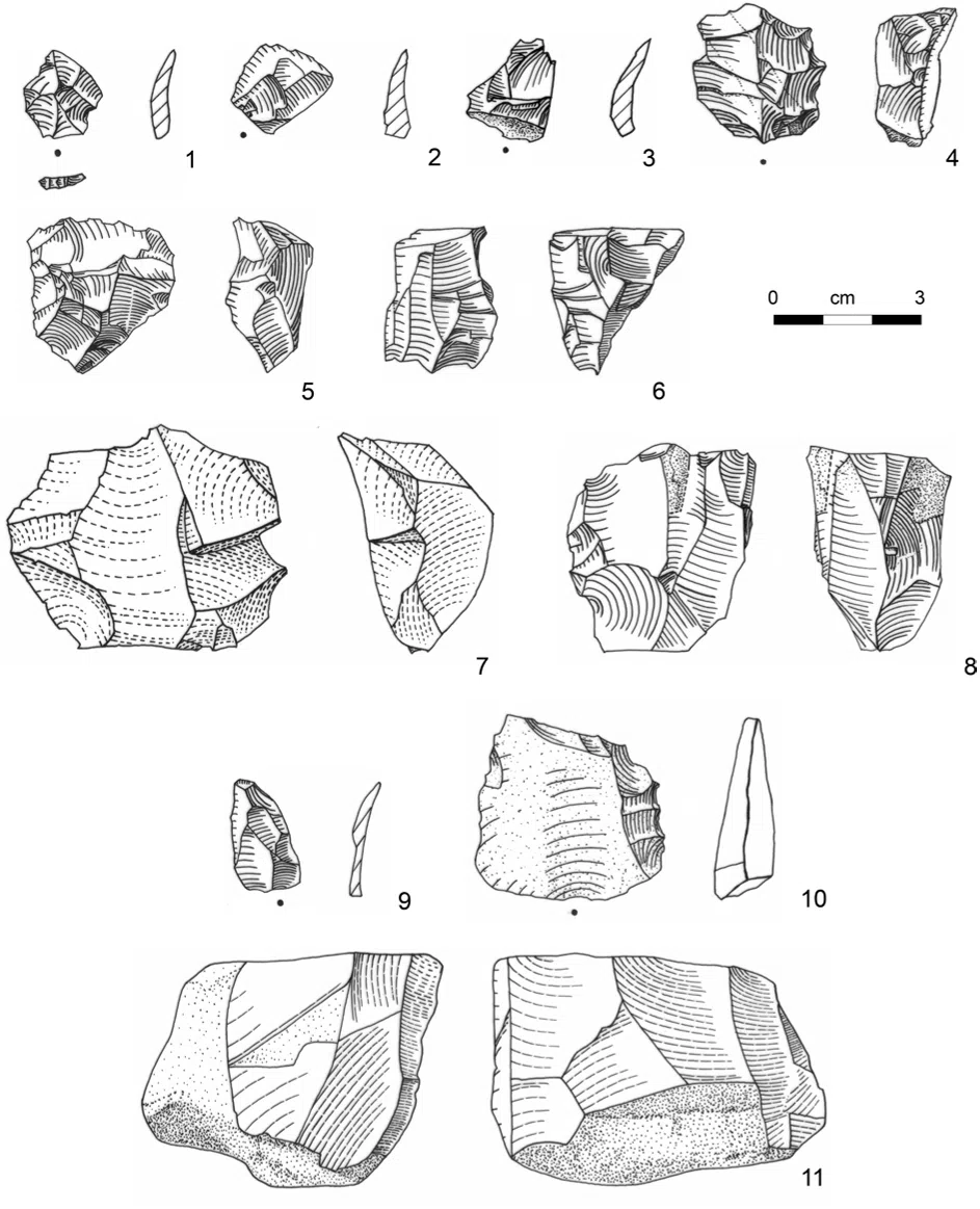
gastropods and Amy Oechsner for drawing the lithics. We are also grateful to all other RBAS
team members for creating a warm, clean and research stimulating environment in Rustaq.
The Anglo-Omani Society in London generously funded the RBAS project. KB wishes to
thank the research project “The role of culture in early expansions of humans” of the
Heidelberg Academy of Science and Humanities for a travel grant and the Gerda Henkel
Stiftung (AZ 06/V/18) for financial support of research at site Hayy al-Sarh.

1
Evidence for Neolithic settlement in the foothills of the Western al-Hajar
Mountains
Abstract
Systematic prospection and excavations in the Rustaq region of Northern Oman,
approximately 45 km from the coast in the foothills of the Western Hajar Mountains, have
revealed an unexpectedly dense record of Neolithic sites. Besides surface scatters of lithic
artifacts, excavation at site Hayy al-Sarh recovered two stratified archaeological horizons
(AHs). The upper horizon, AH I, contained pierced marine shells that provided an age of the
archaeological material of about 6,800 to 7,500 years cal BP. Typologically the AH I lithic
assemblage compares to the Suwayh facies defined at the coast 300 km to the east.
Whether the marine shells and cultural affinities point towards exchange with coastal
communities or possibly seasonal movement remains an open question at this state of
research, but this new evidence for inland Neolithic settlement near Rustaq provides
important new data that will help to improve our understanding of spatial patterns of Neolithic
demographic variability.
Key words: Neolithic, Rustaq, lithic artifacts, marine shells, excavation

2
Introduction
Compared to earlier periods of the Stone Age in Southeast (SE) Arabia, the Early to
Mid-Holocene archaeological record is relatively well understood regarding chronology
and material culture (Charpentier, 2008; Uerpmann et al., 2013). Despite this, important
topics such as the Paleolithic/Neolithic transition and the associated shift in subsistence;
the relationship between inland and coastal settlements; and how people coped with
climatic variability, are still debated (Cavulli and Scaruffi, 2013; Crassard and Drechsler,
2013; Crassard et al., 2013; Drechsler, 2010; Fedele, 2013; Hilbert, 2013; Lézine et al.,
2010). In the context of these questions, significant issues include the spatial distribution of
sites and the precision of the chronologies. Data from stratified inland sites are clearly
underrepresented compared to evidence from the coast where most of the record’s
excavated sites are located (Mery and Charpentier, 2013). Regarding the precision of
chronologies, the influence of the reservoir effect for example is one important topic that is
still debated (see Lindauer et al., 2017 for example).
The Rustaq Batinah Archaeological Survey (RBAS) project, a joint project undertaken by
Durham University UK, Sultan Qaboos University Oman and the Oman Ministry of
Heritage and Culture, has sought to contribute fresh data from new areas to the scientific
discourse. The RBAS conducted systematic field work on the Batinah plain in northern
Oman, which borders the northern foothills of the Western Hajar Mountains. The
project aims to study diachronic changes in settlement dynamics from the Stone Age
until modern times (Kennet et al., 2016). Systematic survey by the project between
2013 and 2018 recovered a rich prehistoric record including the first evidence for
Paleolithic, Neolithic, Bronze Age and Iron Age settlements as well as pre-Islamic and
Islamic period settlement in this area (Kennet et al., 2016). The project has uncovered
a more or less continuous occupation sequence from the Early Bronze Age until at
least the 1970s, broken only by occasional gaps in the record.

3
The Stone Age work group of the RBAS focused its resources on the foothills of the
Western Hajar Mountains in the area around the town of Rustaq (Fig. 1). Here, the RBAS
identified a number of promising landscape features, including apparent Pleistocene-age
terraces and lithic raw material sources (Parton, 2015). Systematic survey of the different
geomorphological features has led to the documentation of Neolithic settlement of so-far
unrecognized intensity. Evidence for Paleolithic settlement in the region was also
documented, but at a much lower density. In this paper we focus on the presentation of the
Neolithic evidence.
Geographic setting
The Batinah plain of northern Oman is a narrow ~35 km wide sequence of alluvial fan
and fan-related drainage features, and coastal deposits. The plain is bordered to the
south-east by the Western Hajar Mountains, which run in an arc parallel to the coast of
the Gulf of Oman and are composed of Mesozoic rocks of the Neotethys margin, Late
Cretaceous-Paleogene thrust faults, Paleogene sediments and post-orogenic faults
(Glennie et al., 1974; Lippard et al., 1986; Rodgers and Gunatilaka, 2002; Searle and
Cox, 1999). Weathered material from the mountains is the predominant sediment
source for much of the plain, while rainfall across the mountain catchment activates
the northeastwards flow of surface and subsurface drainage towards the coast. Within
zones proximal and medial to the mountains, a complex suite of fan deposits are
indicative of higher rainfall throughout northern Oman in earlier times. Phases of large-
scale fan drainage activation in central Oman and along the western flanks of the
mountains have been attributed to incursions of moisture driven by the northward
displacement and intensification of the Indian Ocean Monsoon system (Blechschmidt
et al., 2009; Farrant et al., 2012; Parton et al., 2015). Along the eastern flanks of the

Citations
More filters
Journal ArticleDOI
TL;DR: In this article , the results of excavation at Mugharat al-Kahf (WTN01) in Wadi Tanūf, North-central Oman, were reported, where pottery sherds, charred date stones and other samples for radiocarbon dating were discovered.
Abstract: This paper reports the results of excavation at Mugharat al-Kahf (WTN01) in Wādī Tanūf, North-central Oman. It also provides information on the nonmortuary and nonsedentary activities in central Oman during the Wādī Sūq period (2000–1600 BCE), as the subsistence and social arrangements of this period are the subject of much debate. Previous surveys had discovered a substantial amount of Wādī Sūq pottery at the site. This project took forward the excavation for further exploration. The excavation at Test Pit 1 identified Layers Ia and Ib, wherein pottery sherds, charred date stones and other samples for radiocarbon dating were discovered. These prove the cave's occupation during the early third millennium BCE, early second millennium BCE and the Islamic period. The analysis of artefacts and floral remains provided insights into the sojourn, storage and consumption of dates in the cave, and the mobile lifestyle in central Oman.

2 citations

Journal ArticleDOI
TL;DR: In this article , a study of sediment-filled karst-depressions with lithic scatters at the inner side of the Jebel Kawr on the southern slope of the mountain chain (Kawr Exotic) is presented.
Journal ArticleDOI
TL;DR: In this article , the authors reviewed the short history of landscape archaeology in the area and its relevance, and presented the approach and methods used in the Wadi al Jizzi Archaeological Project and discussed some of the results obtained to discuss both the potential and problems of the data that the project generated.
Abstract: Landscape archaeology, as a type of research based on a systemic surface survey and that results in quantifiable datasets of high quality, has started to be practiced in southeastern Arabia only in recent years. In this paper, I will briefly review the short history of landscape archaeology in the area and its relevance. I will then present the approach and methods used in the Wadi al Jizzi Archaeological Project and discuss some of the results obtained to discuss both the potential and problems of the data that the project generated. In particular, I will focus on ephemeral sites and assemblages, data quality and data representativity.
References
More filters
Journal ArticleDOI
TL;DR: In this paper, the authors reviewed the evidence of personal ornaments from the Mesolithic of the Iron Gates, where such finds were identified in five sites on the Romanian bank: the cave and rock shelter sites of Climente II and Cuina Turcului, and three open-air sites.
Abstract: Personal ornaments, especially those made from the shells of marine mollusks and animal teeth, have been recovered from many Mesolithic sites across Europe. This paper reviews the evidence of personal ornaments from the Mesolithic of the Iron Gates, where such finds were identified in five sites on the Romanian bank: the cave and rock shelter sites of Climente II and Cuina Turcului, and three open-air sites—Icoana, Ostrovul Banului, and Schela Cladovei. The ornaments from these sites were made from the shells of several gastropod taxa and at least one species of dentaliid scaphopod, as well as the pharyngeal teeth of cyprinids, the teeth of several species of terrestrial mammal, fish vertebrae, and pieces of antler and bone. Particular attention is given to taxonomic identification and questions of taphonomy, provenance, selection, manufacture, and use. Experiments were conducted in which several types of ornament were replicated. Archeological and experimental pieces (at various stages of production) were examined under a microscope, to establish the durability of the beads and estimate the length of time over which they were worn. Our results show that shells of Lithoglyphus and Theodoxus sp. were simply perforated and fixed in composed adornments, as were shells of Tritia neritea in the early part of the time range. In the later Mesolithic, T. neritea shells were processed in a different way and fixed to clothing in the manner of appliques. No technological modification of the cyprinid teeth was observed; these were sewn individually onto clothing by means of a thread coated with an adhesive substance. The other categories of personal ornament were used mainly as pendants. Experimental use-wear analysis suggests that many ornaments were used over long periods, with broken or missing pieces replaced when necessary.

12 citations

Journal ArticleDOI
TL;DR: In this article, the archaeological site of Khamseen rock shelter, its stratigraphic succession, numeric ages and Early-Middle Holocene lithic assemblages are presented, and the evidence found at Khamseen and other coeval archaeological sites across southern Arabia is considered.
Abstract: This paper presents the archaeological site of Khamseen rock shelter, its stratigraphic succession, numeric ages and Early–Middle Holocene lithic assemblages. The site was discovered and excavated during the 2010 fieldwork campaign of the Dhofar Archaeological Project (DAP) in southern Oman. It is situated at the southern edge of the Nejd Plateau, strategically positioned adjacent to a major orographic barrier at the interface of the plateau and escarpment. Excavations revealed a succession of five archaeological horizons, each bearing technologically distinct lithic assemblages. The lowest level (GH.5) is attributed to the Khashabian industry, representing the final phase of the South Arabian Late Palaeolithic. Above that, in GH.4, a Neolithic assemblage was found with bifacial tool forms typical of the Middle Holocene. In light of the evidence found at Khamseen rock shelter and other coeval archaeological sites across southern Arabia, the Late Palaeolithic-Neolithic transition is considered.

10 citations

Journal ArticleDOI
TL;DR: In this paper, a review of locational choice from a review at both the regional and local scales, including information obtained from a study of the late A. de Maigret's notebooks, is presented.
Abstract: Knowledge of the Neolithic in the Yemeni highlands still rests on very limited sampling. The available data for the eastern belt of the plateau derive from the Italian Mission’s explorations of 1981–84, still largely unpublished, and a survey conducted in Wadī Khamar in 1987 and 1990. Focusing on settlement problems, this paper attempts an examination of locational choice from a review at both the regional and local scales, including information obtained from a study of the late A. de Maigret’s notebooks. Regionally, specific settlement patterns appear to emerge and significant links to mid-Holocene environmental ‘enclaves’ can be advanced, permitting speculation on land use. On the local scale, site composition and variation are reviewed on the basis of the three excavated sites (Jabal Qut:ran, An-Najid al-Abyaḍ 7 and Wadī aṯ-Ṯayyilah 3). Understanding the specificity of Neolithic settlement in the uplands is still a distant goal, and the considerable unknowns involved are outlined.

9 citations

Frequently Asked Questions (1)
Q1. What are the contributions mentioned in the paper "Evidence for neolithic settlement in the foothills of the western al-hajar mountains running title: neolithic settlement in rustaq" ?

The upper horizon, AH I, contained pierced marine shells that provided an age of the archaeological material of about 6,800 to 7,500 years cal BP. Whether the marine shells and cultural affinities point towards exchange with coastal communities or possibly seasonal movement remains an open question at this state of research, but this new evidence for inland Neolithic settlement near Rustaq provides important new data that will help to improve their understanding of spatial patterns of Neolithic demographic variability.