GPS evidence for northward motion of the Sinai Block: Implications for E. Mediterranean tectonics
TL;DR: In this article, an elastic block model constrained by the GPS results that is consistent with the regional tectonics and allows us to estimate slip rates for Sinai bounding faults, including the Gulf of Aqaba-southern Dead Sea fault system, is presented.
About: This article is published in Earth and Planetary Science Letters.The article was published on 2005-09-30 and is currently open access. It has received 119 citations till now. The article focuses on the topics: Strike-slip tectonics.
Summary (1 min read)
1. Introduction
- The Sinai Peninsula (Fig. 1 ) lies at the northern end of the Red Sea.
- The tectonic history of the Sinai region is intimately tied to the separation of the Arabian plate from Africa along the Red Sea rift system.
- The Red Sea rift basin was well established by early Miocene at which time rifting was concentrated along the Red Sea and its northern extension along the Gulf of Suez [7] .
- Estimates of current fault slip rates in the Gulf of Aqaba and along the DSF vary considerably (e.g., see [12] for references).
- The authors use these velocities, and the velocities of IGS-GPS stations in Israel [12] to constrain an elastic block model to test the consistency of the GPS velocities with coherent block motion and to estimate slip rates on blockbounding faults.
2. GPS velocity field
- Fig. 2 shows GPS-derived velocities in the Sinai network along with velocities from continuously recording stations in surrounding areas relative to Nubia.
- Table 1 lists the velocity estimates and standard deviations.
- With the exception of sites CATH and KENS that were measured 4 times between 1997 and 2000 (sites destroyed), velocities for Sinai survey sites were determined from 5 to 7 surveys conducted between 1996 and 2003.
- In the second step the authors use the loosely constrained estimates of station coordinates, orbits, and EOP and their covariances from each day, aggregated by survey, as quasiobservations in a Kalman filter to estimate a consistent set of coordinates and velocities.
- Before estimating velocities in the second step of their analysis, the authors examine the time series of position esti- mates to determine the appropriate weights to be applied to each group's surveys.
4. Conclusions
- Survey-mode GPS observations in and around the Sinai Peninsula, in combination with continuous GPS observations in Israel, provide evidence for coherent, northerly motion of the Sinai Block.
- On average, the survey data indicate northward motion of 1.4 F 0.8 mm/yr.
- The authors use a simple elastic block model to characterize block motion and associated slip rates on block-bounding faults.
- These models suggest a 13 km locking depth for the DSF with left-lateral slip ranging from 4.4 F 0.3 to 4.7 F 0.4 mm/yr from the southern DSF to the DSF in western Syria.
- The authors are grateful to Muawia Barazangi, Francisco Gomez, Mustapha Meghraoui, and Shimon Wdowinski for helpful reviews that improved the paper.
Did you find this useful? Give us your feedback
Figures (5)
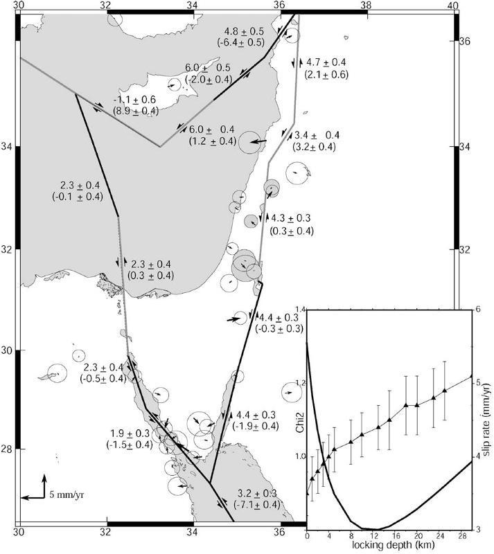
Fig. 3. Elastic block model for the Sinai area showing GPS residual velocities (given in Table 1) for the model described in the text. Faults are vertical and assigned locking depths of 15 km except for the Gulf of Aqaba/Dead Sea fault system that has a locking depth of 13 km, and the western Cyprus Arc that has a 308 dip down to the NE. Residuals are well within the uncertainties for the velocity determinations. Numbers show fault strike slip and fault-normal slip rates and 1-sigma formal uncertainties (fault normal component in brackets; negative for left lateral and extension). Slip rates are averages along each segment. Light modeled faults indicate segments with fault-normal shortening, and dark extension. Inset shows a plot of the local Chi*2 computed from sites close to the fault (shaded error ellipses indicate sites used to estimate fault locking depth) and estimated fault strike slip rate as a function of the locking depth for the Dead Sea fault. The best fit is for a 13 km locking depth and a strike slip rate of 4.3 mm/yr. 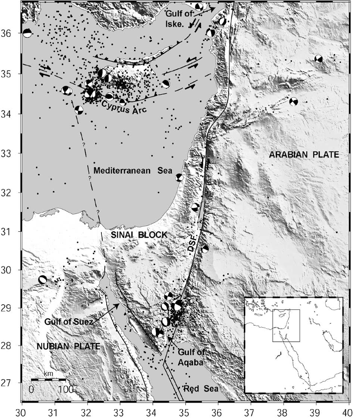
Fig. 1. Topographic (SRTM30) and tectonic map of the Sinai and surrounding region. Dots show seismicity (NEIC), focal mechanisms are from Harvard CMT. Inset shows location of study area within the context of the eastern Mediterranean. DSF=Dead Sea fault, Gulf of Iske.=Gulf of Iskenderum. 
Table 2 Euler vectors relative to Eurasia and 1-sigma uncertainties estimated from this study 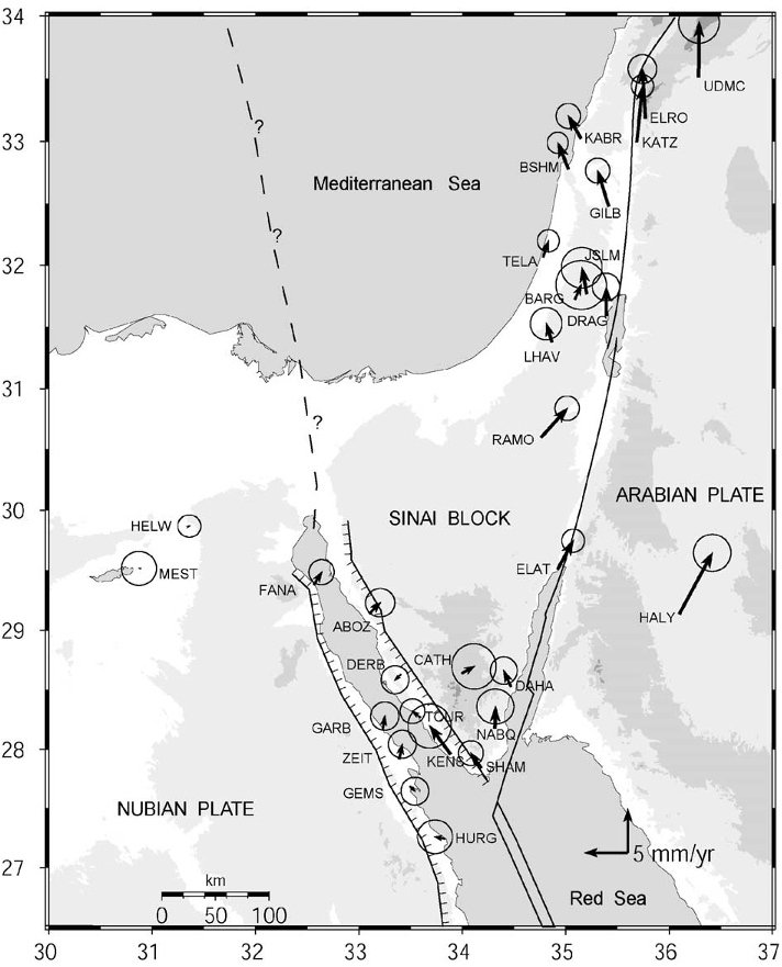
Fig. 2. Simplified tectonic map of the Sinai and surrounding regions show Lines with tick-marks are normal faults, ticks on downthrown block, doubl are given in Table 1. 
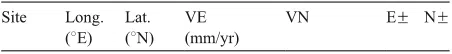
Table 1 GPS velocities in an Africa (Nubia)-fixed reference frame and 1-sigma uncertainties for sites shown in Fig. 2


Citations
More filters
TL;DR: Gomez et al. as mentioned in this paper published an edited version of this paper in Geophysical Journal International by Blackwell Publishing and retained the copyright to this paper (Copyright 2007) and the Blackwell Publishing retains the copyright for this paper.
Abstract: An edited version of this paper was published in Geophysical Journal International by Blackwell Publishing. Blackwell Publishing retains the copyright to this paper (Copyright 2007). See also:
http://www.blackwell-synergy.com/doi/abs/10.1111/j.1365-246X.2006.03328.x;
http://atlas.geo.cornell.edu/deadsea/publications/Gomez2007_GJI.htm
98 citations
TL;DR: In this paper, the authors reconstruct the tectonic evolution of the Messinian evaporites using paleobathymetric constraints from wells and seismic profiles, and infer that both extension and seaward salt flow thinned the evaporite margin and its overburden.
Abstract: Regional 2D and 3D seismic data from the Levant Basin reveal the updip extensional component of thin-skinned gravity tectonics on this continental margin. Because of its youth (5–7 Ma), the earliest stages of deformation of this salt basin are preserved without the severe structural overprinting common on more mature, giant salt-tectonic systems. Extension detaches onto and within Messinian evaporites up to 1800 m thick. By structural restoration, we reconstruct the tectonic evolution of the Messinian evaporites using paleobathymetric constraints from wells and seismic profiles. This analysis suggests that the Mediterranean drawdown during the Messinian Salinity Crisis was ∼800 m. The 10- to 15-km–wide extensional domain tracks the landward pinch-out of the mobile Messinian evaporites against an older Late Miocene scarp. Diachronous extension began in the center of the margin in the mid-Pliocene, then spread northward in the late Pliocene, then finally southward in the early Pleistocene. Extension continues today on many of the most landward faults. Extensional strain varies greatly along strike from <1 km to as much as 12–15 km. Comparing observations with four end-member conceptual models, we infer that both extension and seaward salt flow thinned the evaporite margin and its overburden. Both processes were triggered by a combination of uplift of the continental shoulder of the Dead Sea Rift and subsidence in the Mediterranean Basin. At least three factors controlled variations in extension: (1) degree of tilting of the salt wedge, related to the interplay of coastal uplift and basin subsidence; (2) presence of pre-Messinian canyons overlain by landward salients of salt; and (3) variations in evaporite facies and the proportion of siliciclastic admixture.
92 citations
TL;DR: In this article, the Alpine Fault is modeled as a strike-slip shear zone with largely fault-parallel motion and a flat ductile decollement in the lower crust, and the fault localizes around two-thirds of the plate motion within a 100 km wide zone of distributed deformation.
89 citations
TL;DR: In this paper, the authors present results of the first paleoseismic study of the Yammouneh fault, the main on-land segment of the Levant fault system within the Lebanese restraining bend.
Abstract: We present results of the first paleoseismic study of the Yammouneh fault, the main on-land segment of the Levant fault system within the Lebanese restraining bend. A trench was excavated in the Yammouneh paleolake, where the fault cuts through finely laminated sequences of marls and clays. First-order variations throughout this outstanding stratigraphic record appear to reflect climate change at centennial and millennial scales. The lake beds are offset and deformed in a 2-m- wide zone coinciding with the mapped fault trace. Ten to thirteen events are identified, extending back more than ~12 kyr. Reliable age bounds on seven of these events constrain the mean seismic return time to 1127 ± 135 yr between ~12 ka and ~6.4 ka, implying that this fault slips in infrequent but large (M ~ 7.5) earthquakes. Our results also provide conclusive evidence that the latest event at this site was the great A.D. 1202 historical earthquake, and suggest that the Yammouneh fault might have been the source of a less well-known event circa A.D. 350. These findings, combined with previous paleoseismic data from the Zebadani valley, imply that the parallel faults bounding the Beqaa release strain in events with comparable recurrence intervals but significantly different magnitudes. Our results contribute to document the clustering of large events on the Levant fault into centennial episodes, such as that during the eleventh through twelfth centuries, separated by millennial periods of quiescence, and raise the possibility of a M > 7 event occurring on the Yammouneh fault in the coming century. Such a scenario should be taken into account in regional seismic-hazard assessments and planned for accordingly.
88 citations
TL;DR: In this paper, GPS measurements in NW Syria provide the first direct observations of near-field deformation associated with the northern Dead Sea fault system (DSFS) and demonstrate that the kinematics of the northern section of this transform plate boundary between the Arabian and Sinai plates deviate significantly from plate model predictions.
Abstract: SUMMARY
New Global Positioning System (GPS) measurements in NW Syria provide the first direct observations of near-field deformation associated with the northern Dead Sea fault system (DSFS) and demonstrate that the kinematics of the northern section of this transform plate boundary between the Arabian and Sinai plates deviate significantly from plate model predictions. Velocity estimates based on GPS survey campaigns in 2000, 2007 and 2008, demonstrate left-lateral shear along the northern DSFS with 1σ uncertainties less than 0.7 mm yr−1. These velocities are consistent with an elastic dislocation model with a slip rate of 1.8–3.3 mm yr−1 and a locking depth of 5–16 km. This geodetically determined slip rate is about half of that reported farther south along the central section (Lebanese restraining bend) and the southern section (Jordan Valley and Wadi Araba) of the transform and consequently requires some deformation to occur away from the transform along other geological structures. The factor of two difference in slip rates along the transform is also consistent with differing estimates of total fault slip that have occurred since the mid Miocene: 20–25 km along the northern DSFS (in NW Syria) versus about 45 km along the southern DSFS segment. Some of the strain deficit may be accommodated by north–south shortening within the southwestern segment of the Palmyride fold belt of central Syria. Additionally, a distinct change in velocity occurs within the Sinai plate itself. These new GPS measurements, when viewed alongside the palaeoseismic record and the modest level of present-day seismicity, suggest that the reported estimates of recurrence time of large earthquakes (M > 7) along the northern section of the DSFS may be underestimated owing to temporal clustering of such large historical earthquakes. Hence, a revised estimate of the earthquake hazard may be needed for NW Syria.
80 citations
References
More filters
TL;DR: In this article, the authors present and interpret GPS measurements of crustal motions for the period 1988-1997 at 189 sites extending east-west from the Caucasus mountains to the Adriatic Sea and north-south from the southern edge of the Eurasian plate to the northern edge of Africa.
Abstract: We present and interpret Global Positioning System (GPS) measurements of crustal motions for the period 1988–1997 at 189 sites extending east-west from the Caucasus mountains to the Adriatic Sea and north-south from the southern edge of the Eurasian plate to the northern edge of the African plate. Sites on the northern Arabian platform move 18±2 mm/yr at N25°±5°W relative to Eurasia, less than the NUVEL-1A circuit closure rate (25±1 mm/yr at N21°±7°W). Preliminary motion estimates (1994–1997) for stations located in Egypt on the northeastern part of Africa show northward motion at 5–6±2 mm/yr, also slower than NUVEL-IA estimates (10±1 mm/yr at N2°±4°E). Eastern Turkey is characterized by distributed deformation, while central Turkey is characterized by coherent plate motion (internal deformation of <2 mm/yr) involving westward displacement and counterclockwise rotation of the Anatolian plate. The Anatolian plate is de-coupled from Eurasia along the right-lateral, strike-slip North Anatolian fault (NAF). We derive a best fitting Euler vector for Anatolia-Eurasia motion of 30.7°± 0.8°N, 32.6°± 0.4°E, 1.2°±0.1°/Myr. The Euler vector gives an upper bound for NAF slip rate of 24±1 mm/yr. We determine a preliminary GPS Arabia-Anatolia Euler vector of 32.9°±1.2°N, 40.3°±1.1°E, 0.8°±0.2°/Myr and an upper bound on left-lateral slip on the East Anatolian fault (EAF) of 9±1 mm/yr. The central and southern Aegean is characterized by coherent motion (internal deformation of <2 mm/yr) toward the SW at 30±1 mm/yr relative to Eurasia. Stations in the SE Aegean deviate significantly from the overall motion of the southern Aegean, showing increasing velocities toward the trench and reaching 10±1 mm/yr relative to the southern Aegean as a whole.
1,871 citations
TL;DR: In this article, the evolution of the Tethys belt from the Pliensbachian (190 Ma) to the Tortonian (10 Ma) is depicted at 1 20,000,000 scale.
1,574 citations
TL;DR: In this article, the authors used continuously recording GPS and survey-mode GPS (SGPS) observations to determine Euler vectors for relative motion of the African (Nubian), Arabian and Eurasian plates.
Abstract: SUMMARY We use continuously recording GPS (CGPS) and survey-mode GPS (SGPS) observations to determine Euler vectors for relative motion of the African (Nubian), Arabian and Eurasian plates. We present a well-constrained Eurasia‐Nubia Euler vector derived from 23 IGS sites in Europe and four CGPS and three SGPS sites on the Nubian Plate (−0.95 ± 4.8 ◦ N, −21.8 ± 4.3 ◦ E, 0.06 ± 0.005 ◦ Myr −1 ). We see no significant (> 1m m yr −1 ) internal deformation of the Nubian Plate. The GPS Nubian‐Eurasian Euler vector differs significantly from NUVEL-1A (21.0 ± 4.2 ◦ N, −20.6 ± 0.6 ◦ E, 0.12 ± 0.015 ◦ Myr −1 ), implying more westward motion of Africa relative to Eurasia and slower convergence in the eastern Mediterranean. The Arabia‐ Eurasia and Arabia‐Nubia GPS Euler vectors are less well determined, based on only one CGPS and three SGPS sites on the Arabian Plate. The preliminary Arabia‐Eurasia and Arabia‐ Nubia Euler vectors are 27.4 ± 1.0 ◦ N, 18.4 ± 2.5 ◦ E, 0.40 ± 0.04 ◦ Myr −1 , and 30.5 ± 1.0 ◦ N, 25.7 ± 2.3 ◦ E, 0.37 ± 0.04 ◦ Myr −1 , respectively. The GPS Arabia‐Nubia Euler vector differs significantly from NUVEL-1A (24.1 ± 1.7 ◦ N, 24.0 ± 3.5 ◦ E, 0.40 ± 0.05 ◦ Myr −1 ), but is statistically consistent at the 95 per cent confidence level with the revised Euler vector reported by Chu & Gordon based on a re-evaluation of magnetic anomalies in the Red Sea (31.5 ± 1.2 ◦ N, 23.0 ± 2.7 ◦ E, 0.40 ± 0.05 ◦ Myr −1 ). The motion implied in the Gulf of Aqaba and on the Dead Sea fault (DSF) by the new GPS Nubia‐Arabia Euler vector (i.e. ignoring possible Sinai block motion and possible internal plate deformation) grades from pure left lateral strike-slip in the Gulf and on the southern DSF with increasing compression on the central and northern DSF with relative motion increasing from 5.6 to 7.5 mm yr −1 (± 1m m yr −1 ) from south to north. Along the northern DSF (i.e. north of the Lebanon restraining bend) motion is partitioned between 6 ± 1m m yr −1 left-lateral motion parallel to the fault trace and 4 ± 1m m yr −1 faultnormal compression. Relative motions on other plate boundaries (including the Anatolian and Aegean microplates) derived from the GPS Euler vectors agree qualitatively with the sense of motion indicated by focal mechanisms for large crustal earthquakes (M > 6). Where data are available on fault-slip rates on plate bounding faults (North Anatolian fault, East Anatolian fault, Dead Sea fault, Red Sea rift), they are generally lower than, but not significantly different from, the full plate motion estimates suggesting that the majority of relative plate motion is accommodated on these structures.
683 citations
TL;DR: The seismicity and fault plane solutions in the Mediterranean area show that two small rapidly moving plates exist in the Eastern Mediterranean, and such plates may be a common feature of contracting ocean basins.
Abstract: The seismicity and fault plane solutions in the Mediterranean area show that two small rapidly moving plates exist in the Eastern Mediterranean, and such plates may be a common feature of contracting ocean basins. The results show that the concepts of plate tectonics apply to instantaneous motions across continental plate boundaries.
666 citations
TL;DR: In this article, an approach for efficiently combining different types of geodetic data to estimate time-dependent motions of stations in a region of active deformation is discussed. But the work is limited to the case of finite constraints and stochastic perturbation of parameters.
Abstract: We discuss an approach for efficiently combining different types of geodetic data to estimate time-dependent motions of stations in a region of active deformation. The primary observations are analyzed separately to produce loosely constrained estimates of station positions and coordinate system parameters which are then combined with appropriate constraints to estimate velocities and coseismic displacements. We define noninteger degrees of freedom to handle the case of finite constraints and stochastic perturbation of parameters and develop statistical tests for determining compatibility between different data sets. With these developments, we show an example of combining space and terrestrial geodetic data to obtain the deformation field in southern California.
393 citations