GPS evidence for northward motion of the Sinai Block: Implications for E. Mediterranean tectonics
TL;DR: In this article, an elastic block model constrained by the GPS results that is consistent with the regional tectonics and allows us to estimate slip rates for Sinai bounding faults, including the Gulf of Aqaba-southern Dead Sea fault system, is presented.
About: This article is published in Earth and Planetary Science Letters.The article was published on 2005-09-30 and is currently open access. It has received 119 citations till now. The article focuses on the topics: Strike-slip tectonics.
Summary (1 min read)
1. Introduction
- The Sinai Peninsula (Fig. 1 ) lies at the northern end of the Red Sea.
- The tectonic history of the Sinai region is intimately tied to the separation of the Arabian plate from Africa along the Red Sea rift system.
- The Red Sea rift basin was well established by early Miocene at which time rifting was concentrated along the Red Sea and its northern extension along the Gulf of Suez [7] .
- Estimates of current fault slip rates in the Gulf of Aqaba and along the DSF vary considerably (e.g., see [12] for references).
- The authors use these velocities, and the velocities of IGS-GPS stations in Israel [12] to constrain an elastic block model to test the consistency of the GPS velocities with coherent block motion and to estimate slip rates on blockbounding faults.
2. GPS velocity field
- Fig. 2 shows GPS-derived velocities in the Sinai network along with velocities from continuously recording stations in surrounding areas relative to Nubia.
- Table 1 lists the velocity estimates and standard deviations.
- With the exception of sites CATH and KENS that were measured 4 times between 1997 and 2000 (sites destroyed), velocities for Sinai survey sites were determined from 5 to 7 surveys conducted between 1996 and 2003.
- In the second step the authors use the loosely constrained estimates of station coordinates, orbits, and EOP and their covariances from each day, aggregated by survey, as quasiobservations in a Kalman filter to estimate a consistent set of coordinates and velocities.
- Before estimating velocities in the second step of their analysis, the authors examine the time series of position esti- mates to determine the appropriate weights to be applied to each group's surveys.
4. Conclusions
- Survey-mode GPS observations in and around the Sinai Peninsula, in combination with continuous GPS observations in Israel, provide evidence for coherent, northerly motion of the Sinai Block.
- On average, the survey data indicate northward motion of 1.4 F 0.8 mm/yr.
- The authors use a simple elastic block model to characterize block motion and associated slip rates on block-bounding faults.
- These models suggest a 13 km locking depth for the DSF with left-lateral slip ranging from 4.4 F 0.3 to 4.7 F 0.4 mm/yr from the southern DSF to the DSF in western Syria.
- The authors are grateful to Muawia Barazangi, Francisco Gomez, Mustapha Meghraoui, and Shimon Wdowinski for helpful reviews that improved the paper.
Did you find this useful? Give us your feedback
Figures (5)
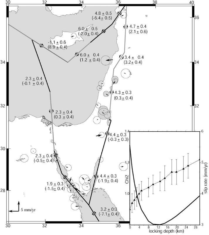
Fig. 3. Elastic block model for the Sinai area showing GPS residual velocities (given in Table 1) for the model described in the text. Faults are vertical and assigned locking depths of 15 km except for the Gulf of Aqaba/Dead Sea fault system that has a locking depth of 13 km, and the western Cyprus Arc that has a 308 dip down to the NE. Residuals are well within the uncertainties for the velocity determinations. Numbers show fault strike slip and fault-normal slip rates and 1-sigma formal uncertainties (fault normal component in brackets; negative for left lateral and extension). Slip rates are averages along each segment. Light modeled faults indicate segments with fault-normal shortening, and dark extension. Inset shows a plot of the local Chi*2 computed from sites close to the fault (shaded error ellipses indicate sites used to estimate fault locking depth) and estimated fault strike slip rate as a function of the locking depth for the Dead Sea fault. The best fit is for a 13 km locking depth and a strike slip rate of 4.3 mm/yr. 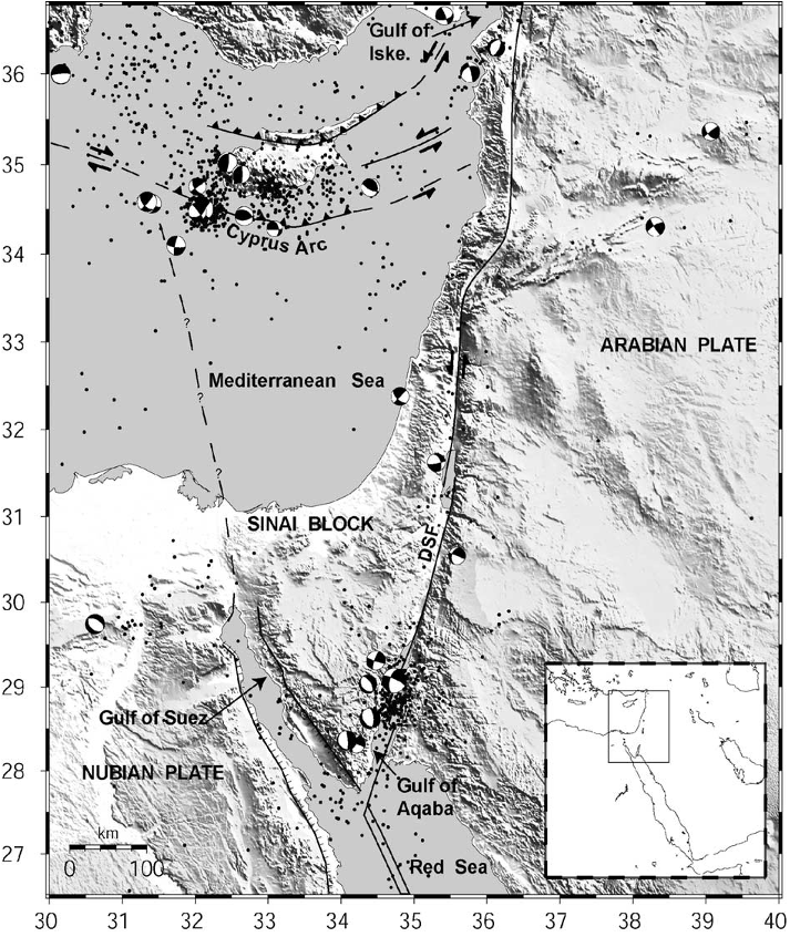
Fig. 1. Topographic (SRTM30) and tectonic map of the Sinai and surrounding region. Dots show seismicity (NEIC), focal mechanisms are from Harvard CMT. Inset shows location of study area within the context of the eastern Mediterranean. DSF=Dead Sea fault, Gulf of Iske.=Gulf of Iskenderum. 
Table 2 Euler vectors relative to Eurasia and 1-sigma uncertainties estimated from this study 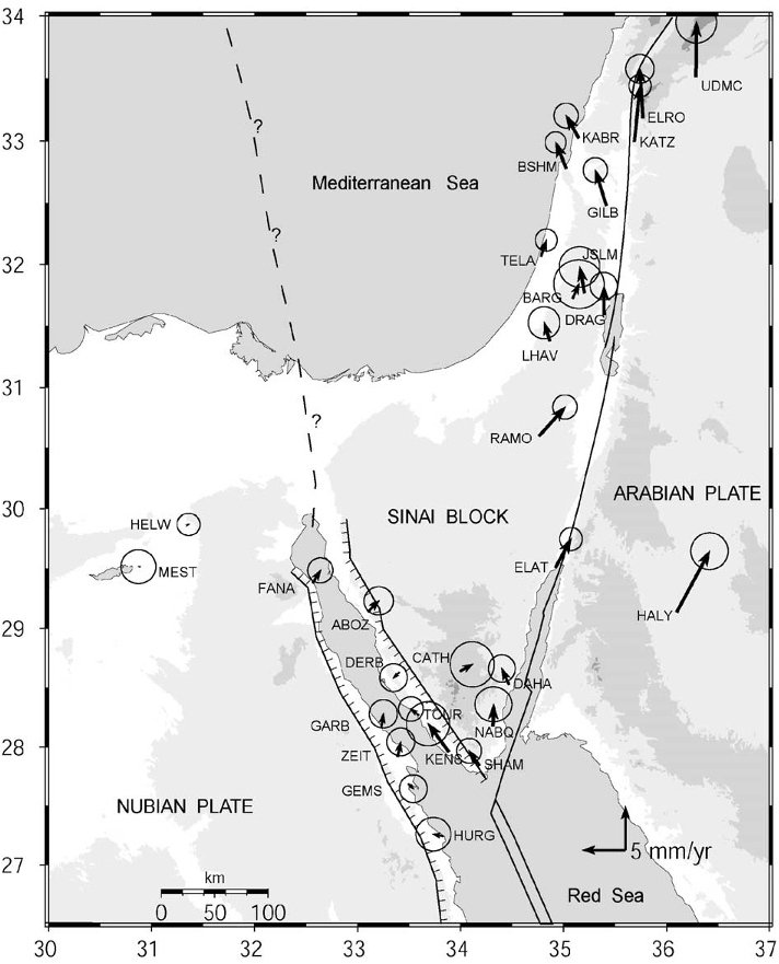
Fig. 2. Simplified tectonic map of the Sinai and surrounding regions show Lines with tick-marks are normal faults, ticks on downthrown block, doubl are given in Table 1. 
Table 1 GPS velocities in an Africa (Nubia)-fixed reference frame and 1-sigma uncertainties for sites shown in Fig. 2


Citations
More filters
TL;DR: In this article, the in-situ stress field, pore pressure, stress regime, and fracture gradient in the Hilal oil field at the southern Gulf of Suez, Egypt were analyzed.
50 citations
TL;DR: In this article, Morphotectonic lineaments observed on the Sinai Peninsula in Egypt were auto-detected from Shuttle Radar Topography Mission 90-m digital elevation model (DEM) and gravity grid data and then analyzed to characterize the tectonic trends that dominated the geologic evolution of this area.
49 citations
TL;DR: In this article, the slip rates for Wadi Araba and Jordan Valley faults are estimated using elastic dislocation models with 1-sigma uncertainties ranging from 4-10 mm/yr.
Abstract: Analysis of short-term deformation along the southern part of Dead Sea Fault (DSF) provides a systematic view of kinematics this part of the continental transform The southern DSF consists of two principal segments: the Wadi Araba and Jordan Valley faults In addition to other regional continuous GPS data, this study uses new data from 25 survey sites and 4 continuous GPS stations in Jordan for improved near-field observations Resulting velocities are reported with 1-sigma uncertainties ranging from 04-10 mm/yr Application of elastic dislocation models yields estimates of slip rates for Wadi Araba and Jordan Valley faults are 49 +/- 04 mm/yr and 47 +/- 04 mm/yr, respectively Modeling also suggests different depths of effective fault locking with 15 +/- 5 km and 8 +/- 5 km for the Wadi Araba and Jordan Valley faults, respectively These slip rates are generally consistent with the upper end of the range of slip rates estimated from late Quaternary geology Spatial variations in effective fault locking generally correspond with a heterogeneous mantle lithosphere A similar observation can be observed along the southern San Andreas Fault, and this may reflect the influence of heterogeneity in the uppermost mantle on crustal faulting processes
49 citations
TL;DR: In this paper, the authors examined the slip evolution of a fault embedded in an elastic lithosphere loaded by plate motion and showed that high fault stress and low lithospheric stiffness favour large variations of slip rate.
48 citations
TL;DR: In this article, a detailed soil gas sampling was performed to understand the origin of soil gas emanation and its relationship with the tectonics of the Amik Basin (Hatay), which is characterized by important tectonic lineaments, which consist mainly of the Dead Sea Fault (DSF), the Karasu Fault, and the East Anatolian Fault (EAF).
46 citations
References
More filters
TL;DR: In this article, the authors present and interpret GPS measurements of crustal motions for the period 1988-1997 at 189 sites extending east-west from the Caucasus mountains to the Adriatic Sea and north-south from the southern edge of the Eurasian plate to the northern edge of Africa.
Abstract: We present and interpret Global Positioning System (GPS) measurements of crustal motions for the period 1988–1997 at 189 sites extending east-west from the Caucasus mountains to the Adriatic Sea and north-south from the southern edge of the Eurasian plate to the northern edge of the African plate. Sites on the northern Arabian platform move 18±2 mm/yr at N25°±5°W relative to Eurasia, less than the NUVEL-1A circuit closure rate (25±1 mm/yr at N21°±7°W). Preliminary motion estimates (1994–1997) for stations located in Egypt on the northeastern part of Africa show northward motion at 5–6±2 mm/yr, also slower than NUVEL-IA estimates (10±1 mm/yr at N2°±4°E). Eastern Turkey is characterized by distributed deformation, while central Turkey is characterized by coherent plate motion (internal deformation of <2 mm/yr) involving westward displacement and counterclockwise rotation of the Anatolian plate. The Anatolian plate is de-coupled from Eurasia along the right-lateral, strike-slip North Anatolian fault (NAF). We derive a best fitting Euler vector for Anatolia-Eurasia motion of 30.7°± 0.8°N, 32.6°± 0.4°E, 1.2°±0.1°/Myr. The Euler vector gives an upper bound for NAF slip rate of 24±1 mm/yr. We determine a preliminary GPS Arabia-Anatolia Euler vector of 32.9°±1.2°N, 40.3°±1.1°E, 0.8°±0.2°/Myr and an upper bound on left-lateral slip on the East Anatolian fault (EAF) of 9±1 mm/yr. The central and southern Aegean is characterized by coherent motion (internal deformation of <2 mm/yr) toward the SW at 30±1 mm/yr relative to Eurasia. Stations in the SE Aegean deviate significantly from the overall motion of the southern Aegean, showing increasing velocities toward the trench and reaching 10±1 mm/yr relative to the southern Aegean as a whole.
1,871 citations
TL;DR: In this article, the evolution of the Tethys belt from the Pliensbachian (190 Ma) to the Tortonian (10 Ma) is depicted at 1 20,000,000 scale.
1,574 citations
TL;DR: In this article, the authors used continuously recording GPS and survey-mode GPS (SGPS) observations to determine Euler vectors for relative motion of the African (Nubian), Arabian and Eurasian plates.
Abstract: SUMMARY We use continuously recording GPS (CGPS) and survey-mode GPS (SGPS) observations to determine Euler vectors for relative motion of the African (Nubian), Arabian and Eurasian plates. We present a well-constrained Eurasia‐Nubia Euler vector derived from 23 IGS sites in Europe and four CGPS and three SGPS sites on the Nubian Plate (−0.95 ± 4.8 ◦ N, −21.8 ± 4.3 ◦ E, 0.06 ± 0.005 ◦ Myr −1 ). We see no significant (> 1m m yr −1 ) internal deformation of the Nubian Plate. The GPS Nubian‐Eurasian Euler vector differs significantly from NUVEL-1A (21.0 ± 4.2 ◦ N, −20.6 ± 0.6 ◦ E, 0.12 ± 0.015 ◦ Myr −1 ), implying more westward motion of Africa relative to Eurasia and slower convergence in the eastern Mediterranean. The Arabia‐ Eurasia and Arabia‐Nubia GPS Euler vectors are less well determined, based on only one CGPS and three SGPS sites on the Arabian Plate. The preliminary Arabia‐Eurasia and Arabia‐ Nubia Euler vectors are 27.4 ± 1.0 ◦ N, 18.4 ± 2.5 ◦ E, 0.40 ± 0.04 ◦ Myr −1 , and 30.5 ± 1.0 ◦ N, 25.7 ± 2.3 ◦ E, 0.37 ± 0.04 ◦ Myr −1 , respectively. The GPS Arabia‐Nubia Euler vector differs significantly from NUVEL-1A (24.1 ± 1.7 ◦ N, 24.0 ± 3.5 ◦ E, 0.40 ± 0.05 ◦ Myr −1 ), but is statistically consistent at the 95 per cent confidence level with the revised Euler vector reported by Chu & Gordon based on a re-evaluation of magnetic anomalies in the Red Sea (31.5 ± 1.2 ◦ N, 23.0 ± 2.7 ◦ E, 0.40 ± 0.05 ◦ Myr −1 ). The motion implied in the Gulf of Aqaba and on the Dead Sea fault (DSF) by the new GPS Nubia‐Arabia Euler vector (i.e. ignoring possible Sinai block motion and possible internal plate deformation) grades from pure left lateral strike-slip in the Gulf and on the southern DSF with increasing compression on the central and northern DSF with relative motion increasing from 5.6 to 7.5 mm yr −1 (± 1m m yr −1 ) from south to north. Along the northern DSF (i.e. north of the Lebanon restraining bend) motion is partitioned between 6 ± 1m m yr −1 left-lateral motion parallel to the fault trace and 4 ± 1m m yr −1 faultnormal compression. Relative motions on other plate boundaries (including the Anatolian and Aegean microplates) derived from the GPS Euler vectors agree qualitatively with the sense of motion indicated by focal mechanisms for large crustal earthquakes (M > 6). Where data are available on fault-slip rates on plate bounding faults (North Anatolian fault, East Anatolian fault, Dead Sea fault, Red Sea rift), they are generally lower than, but not significantly different from, the full plate motion estimates suggesting that the majority of relative plate motion is accommodated on these structures.
683 citations
TL;DR: The seismicity and fault plane solutions in the Mediterranean area show that two small rapidly moving plates exist in the Eastern Mediterranean, and such plates may be a common feature of contracting ocean basins.
Abstract: The seismicity and fault plane solutions in the Mediterranean area show that two small rapidly moving plates exist in the Eastern Mediterranean, and such plates may be a common feature of contracting ocean basins. The results show that the concepts of plate tectonics apply to instantaneous motions across continental plate boundaries.
666 citations
TL;DR: In this article, an approach for efficiently combining different types of geodetic data to estimate time-dependent motions of stations in a region of active deformation is discussed. But the work is limited to the case of finite constraints and stochastic perturbation of parameters.
Abstract: We discuss an approach for efficiently combining different types of geodetic data to estimate time-dependent motions of stations in a region of active deformation. The primary observations are analyzed separately to produce loosely constrained estimates of station positions and coordinate system parameters which are then combined with appropriate constraints to estimate velocities and coseismic displacements. We define noninteger degrees of freedom to handle the case of finite constraints and stochastic perturbation of parameters and develop statistical tests for determining compatibility between different data sets. With these developments, we show an example of combining space and terrestrial geodetic data to obtain the deformation field in southern California.
393 citations