Groundwater Level Status Report for Fiscal Year 2007 - Los Alamos National Laboratory
Summary (1 min read)
1.0 Introduction
- This report includes groundwater level data obtained during FY 2007 (October 1, 2006 , through September 30, 2007) and, where available, historical data.
- The groundwater level data are presented on time-series graphs to provide a comprehensive representation of the groundwater level characteristics, to the extent possible with available data.
- For the alluvial wells, the first graph for each well represents the entire period of record, while the second graph represents FY 2007 to provide better representation of recent and seasonal changes.
2.0 Description of Groundwater Le vel Data
- Previous reports of groundwater level data at LANL were compiled for the regional aquifer test wells (TWs) by Koch et al. (2004) and for all wells in a submittal to the New Mexico Environment Department in January 2005 (LANL 2005) .
- Groundwater levels in water supply wells at Los Alamos have been summarized in the series of water supply reports for Los Alamos, e.g., Koch and Rogers (2003) .
3.38 Test Well 1
- The following sections include additional port and construction information for single and multiple completion intermediate wells at LANL.
- Time-series groundwater level data are shown for each well.
5.0 Groundwater Le vel Data from Alluvial Wells
- Table 5 -1 lists the alluvial wells that were monitored for groundwater levels in FY 2007.
- The table provides the well name, date of completion, well depth, surveyed location coordinates, ground surface elevation, and the screen top and bottom depths for each well.
- In the following alluvial groundwater sections, the first graph for each well represents the entire period of record, while the second graph represents groundwater level data from FY 2007.
- Alluvial groundwater levels respond to snowmelt runoff, storm runoff, and, in some canyons, effluent discharges.
Did you find this useful? Give us your feedback
Figures (7)

Table 6-1. General Information for Los Alamos County Water Supply Wells 
Table 5-1. Information and Location Data for Alluvial Aquifer Wells at LANL 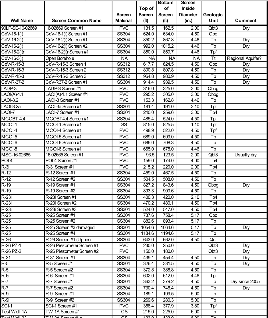
Table 4-2. Well Completion Information for Intermediate Wells and Screens 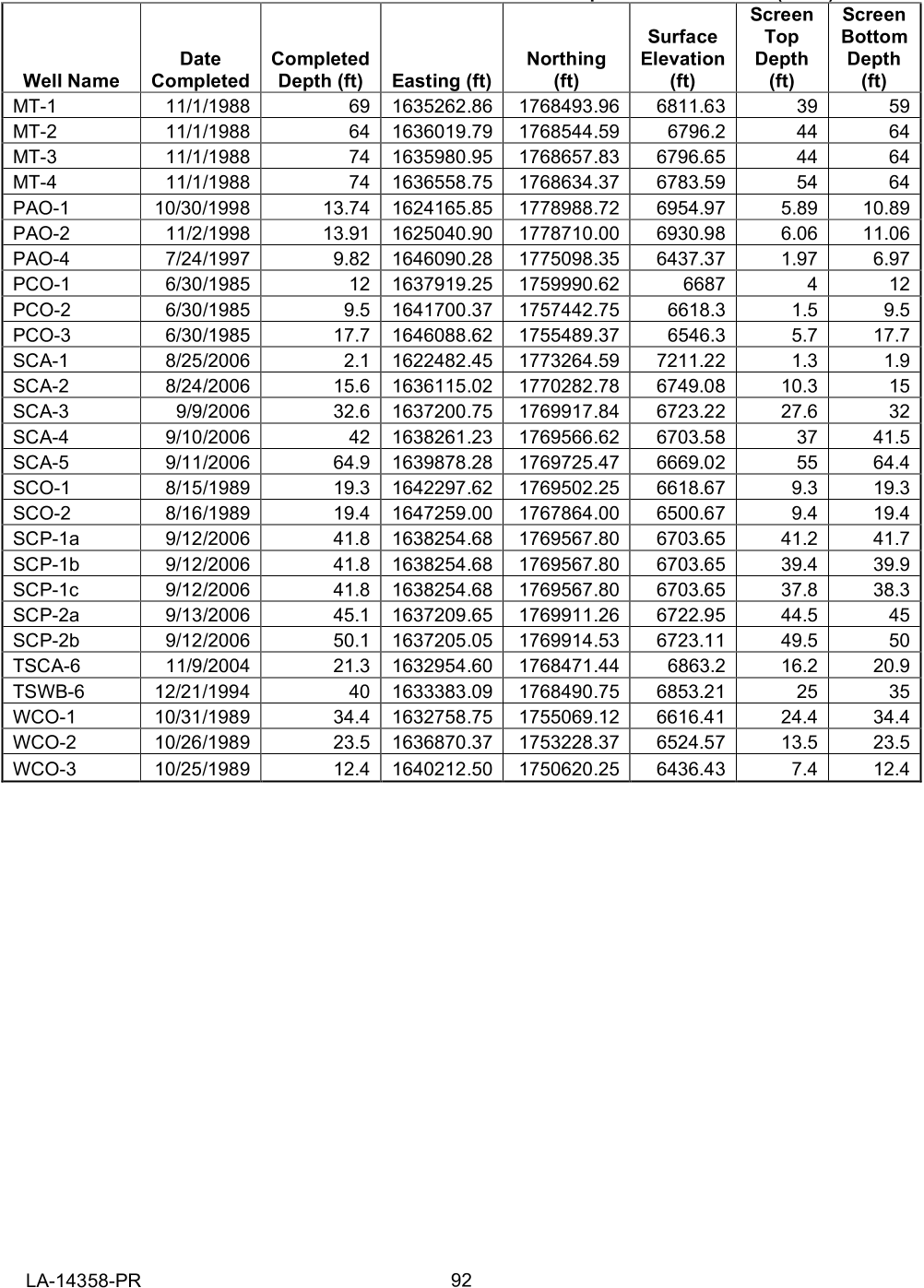
Table 5-1. Information and Location Data for Alluvial Aquifer Wells at LANL 
Table 3-1. General Information for Regional Aquifer Wells 
Table 5-1. Information and Location Data for Alluvial Aquifer Wells at LANL 
Table 4-1. General Information for Intermediate Wells at LANL


Citations
24 citations
6 citations
Cites methods from "Groundwater Level Status Report for..."
...The previous reports in this series, Groundwater Level Status Report for 2005, was issued in May 2006 (Allen and Koch 2006), Groundwater Level Status Report for Fiscal Year 2006 (Allen and Koch 2007) was issued in March 2007, and Groundwater Level Status Report for Fiscal Year 2007 (Allen and Koch 2008) was issued in March 2008....
[...]
...…Groundwater Level Status Report for 2005, was issued in May 2006 (Allen and Koch 2006), Groundwater Level Status Report for Fiscal Year 2006 (Allen and Koch 2007) was issued in March 2007, and Groundwater Level Status Report for Fiscal Year 2007 (Allen and Koch 2008) was issued in March 2008....
[...]
2 citations
Cites background from "Groundwater Level Status Report for..."
...…Report for Fiscal Year 2006, issued in March 2007 (Allen and Koch 2007); Groundwater Level Status Report for Fiscal Year 2007, issued in March 2008 (Allen and Koch 2008); Groundwater Level Status Report for 2008, issued in March 2009 (Koch and Schmeer 2009), and Groundwater Level Status Report for…...
[...]
...The previous reports in this series are as follows: Groundwater Level Status Report for 2005, issued in May 2006 (Allen and Koch 2006); Groundwater Level Status Report for Fiscal Year 2006, issued in March 2007 (Allen and Koch 2007); Groundwater Level Status Report for Fiscal Year 2007, issued in March 2008 (Allen and Koch 2008); Groundwater Level Status Report for 2008, issued in March 2009 (Koch and Schmeer 2009), and Groundwater Level Status Report for 2009, issued in March 2010 (Koch and Schmeer 2010)....
[...]
References
24 citations
6 citations
2 citations