scispace - formally typeset
Search or ask a question
Journal ArticleDOI

Improved ozone DIAL retrievals in the upper troposphere and lower stratosphere using an optimal estimation method

20 Feb 2019-Applied Optics (Optical Society of America)-Vol. 58, Iss: 6, pp 1374-1385
TL;DR: A first-principle optimal estimation method to retrieve ozone density profiles using simultaneously tropospheric and stratospheric differential absorption lidar (DIAL) measurements shows a significant improvement in the overlapping region, where the optimal estimation methods can retrieve a single ozone profile consistent with the measurements from both lidars.
Abstract: We have implemented a first-principle optimal estimation method to retrieve ozone density profiles using simultaneously tropospheric and stratospheric differential absorption lidar (DIAL) measurements. Our retrieval extends from 2.5 km to about 42 km in altitude, and in the upper troposphere and the lower stratosphere (UTLS) it shows a significant improvement in the overlapping region, where the optimal estimation method (OEM) can retrieve a single ozone profile consistent with the measurements from both lidars. Here stratospheric and tropospheric measurements from the Observatoire de Haute Provence are used, and the OEM retrievals in the UTLS region compared with coincident ozonesonde measurements. The retrieved ozone profiles have a small statistical uncertainty in the UTLS region relative to individual determinations of ozone from each lidar, and the maximum statistical uncertainty does not exceed a maximum of 7%.

Summary (2 min read)

1. INTRODUCTION

  • The upper troposphere and lower stratosphere (UTLS) extends from about 6 km to 25 km in height and plays a significant role in the atmospheric climate system.
  • Providing a single ozone profile with a full uncertainty budget using both sets of measurements can significantly improve their measurements of ozone in the UTLS [13] [14] [15] .
  • The OEM also provides averaging kernels of the retrievals, which allows comparison of the profiles with other measurements which can account for differences in vertical resolution, such as when compared to space-based measurements.
  • Moreover, the state vectors and the b parameter quantities are defined and a brief overview of the lidar's specifications is given.

2. METHODOLOGY

  • In the DIAL system, two wavelengths are simultaneously transmitted to the atmosphere.
  • Any corrections due to nonlinearity of the counting system (because of saturation) should also be applied to the raw counts.
  • The authors use the lidar equation as the forward model, where the raw counts are the measurements.
  • The geometrical overlap is O(z), and β(λ i , z) are the atmospheric backscattering coefficients which includes both molecular and aerosol terms.

A. Implementing the OEM for the OHP lidars

  • Knowing the measurements vector and its covariance matrix S , and using an a priori profile and its associated covariance matrix S a , the OEM calculates an optimal a posteriori state by minimizing a cost function: EQUATION.
  • The iteration stops when the cost function decreases to a value much smaller than the number of measurements.
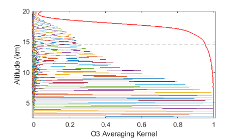
  • The relation between the retrieved state and the true state is described by the averaging kernel of the retrieval.
  • The altitude above which the background counts are determined is different for tropospheric and stratospheric lidars.
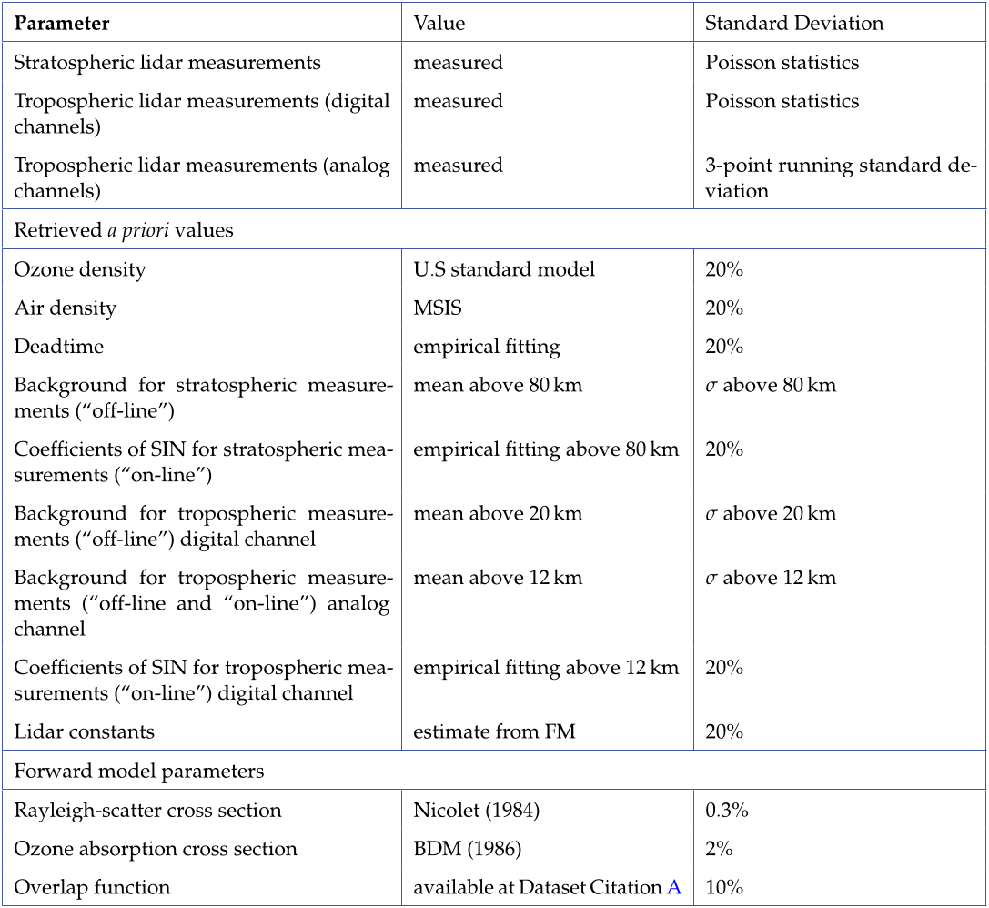
  • The overlap function, Rayleigh cross sections, and ozone absorption cross sections are assumed as b parameters.

3. OEM OZONE RETRIEVAL IN THE FREE TROPOSPHERE AND STRATOSPHERE

  • In this section the authors present the result of combining the two lidar measurements to retrieve a single ozone profile.
  • As a result the red line (which indicates the noise of measurements) for the analog channels is more structured then for the digital channels. of 12 July 2017 is retrieved from 2.6 km to 42.2 km altitude.
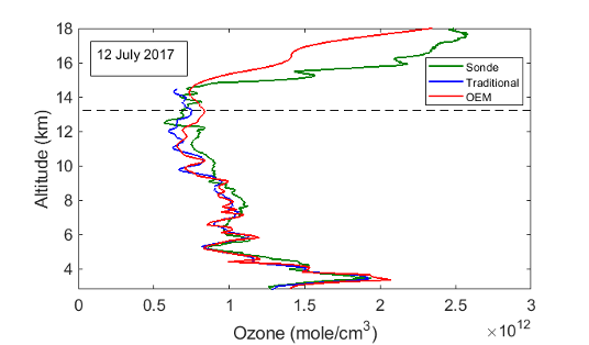
  • In Fig. 3 the OEM retrieval is plotted against the traditional stratospheric and tropospheric retrievals.
  • The Rayleigh-scatter cross section uncertainty for both tropospheric and stratospheric lidars has a significant contribution.
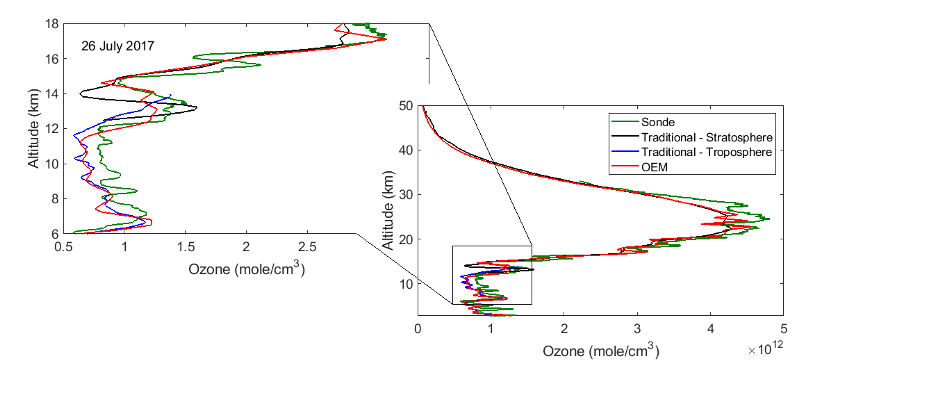
  • Ozone density profiles are also retrieved for the nights of 14 July 2017, and 26 July 2017, each of which also had coincident ozonesonde measurements.

4. SUMMARY

  • The authors have introduced a first-principles OEM retrieval for tropospheric ozone profiles, as well as for a combination of tropospheric and stratospheric ozone profiles.
  • The results from their implementation of the OEM are summarized below.
  • The combined stratospheric-tropospheric DIAL OEM retrieval calculate a single ozone profile consistent with all the measurements.
  • For the tropospheric retrievals, the traditional method and their OEM retrieval produce similar results.
  • At the region where the tropospheric and stratospheric lidar measurements overlap, the OEM can smoothly makes a transition from one lidar system's measurements to the other system's measurements.

5. CONCLUSIONS

  • The authors used simultaneous tropospheric and stratospheric lidar measurements with the OEM to retrieved ozone profile from 2.5 km to above 40 km.
  • The OEM method has no need for "gluing" or "merging" the tropospheric and stratospheric measurements, as all measurements are simultaneously considered when retrieving a single ozone profile.
  • The authors forward model has been tested under clear sky conditions.
  • In the UTLS region, clouds and significant aerosol loads can exist.
  • Furthermore, as their methods allows the calculation of averaging kernels for the retrieval, the authors are interested in comparing their retrievals with satellite measurements, as well as processing more of the OHP measurements.

Did you find this useful? Give us your feedback

Figures (14)

Content maybe subject to copyright    Report

HAL Id: insu-02183026
https://hal-insu.archives-ouvertes.fr/insu-02183026
Submitted on 8 Dec 2020
HAL is a multi-disciplinary open access
archive for the deposit and dissemination of sci-
entic research documents, whether they are pub-
lished or not. The documents may come from
teaching and research institutions in France or
abroad, or from public or private research centers.
L’archive ouverte pluridisciplinaire HAL, est
destinée au dépôt et à la diusion de documents
scientiques de niveau recherche, publiés ou non,
émanant des établissements d’enseignement et de
recherche français ou étrangers, des laboratoires
publics ou privés.
Improved ozone DIAL retrievals in the upper
troposphere and lower stratosphere using an optimal
estimation method
Ghazal Farhani, Robert J. Sica, Sophie Godin-Beekmann, Gérard Ancellet,
Alexander Haefele
To cite this version:
Ghazal Farhani, Robert J. Sica, Sophie Godin-Beekmann, Gérard Ancellet, Alexander Haefele.
Improved ozone DIAL retrievals in the upper troposphere and lower stratosphere using an opti-
mal estimation method. Applied optics, Optical Society of America, 2019, 58 (6), pp.1374-1385.
�10.1364/AO.58.001374�. �insu-02183026�

Research Article Applied Optics 1
Improved ozone DIAL retrievals in the upper
troposphere and lower stratosphere using an optimal
estimation method
GHAZAL FARHANI
1,*
, ROBERT J. SICA
1
, SOPHIE GODIN-BEEKMANN
2
, GÈRARD ANCELLET
2
, AND
ALEXANDER HAEFELE
3
1
Department of Physics and Astronomy, The University of Western Ontario, 1151 Richmond St., London, ON, N6A 3K7
2
Observatoire de Versailles Saint-Quentin-en-Yvelines, Guyancourt, France 78280
3
Federal Office of Meteorology and Climatology MeteoSwiss, Payerne, Switzerland 1530
*
Corresponding author: gfarhani@uwo.ca
Compiled October 31, 2018
We have implemented a first-principle Optimal Estimation Method to retrieve ozone density profiles us-
ing simultaneously tropospheric and stratospheric Differential Absorption Lidar (DIAL) measurements.
Our retrieval extends from 2.5 km to about 42 km in altitude, and in the upper troposphere and the lower
stratosphere (UTLS) it shows a significant improvement in the overlapping region, where the OEM can
retrieve a single ozone profile consistent with the measurements from both lidars. Here stratospheric
and the tropospheric measurements from the Observatoire de Haute Provence are used, and the OEM
retrievals in the UTLS region compared with coincident ozonesonde measurements. The retrieved ozone
profile have a small statistical uncertainty in the UTLS region relative to individual determinations of
ozone from each lidar, and the maximum statistical uncertainty does not exceed a maximum of 7%. © 2018
Optical Society of America
http://dx.doi.org/10.1364/ao.XX.XXXXXX
1. INTRODUCTION
The upper troposphere and lower stratosphere (UTLS) extends from about 6 km to 25 km in height and plays
a significant role in the atmospheric climate system. In this region of the atmosphere, even small changes
in temperature and in the distribution and concentration of greenhouse gases can result in large changes in
atmospheric radiative forcing, which can trigger climate change [1, 2].
Ozone in the upper troposphere acts as the third largest greenhouse gas contributing to the radiative
forcing of climate change [
1
,
3
]. The ozone distribution in the UTLS is the result of transport mechanisms and
photochemical reactions. Because of stratospheric tropospheric exchange, large spatial and temporal variability
can be observed in the UTLS [4].
In many studies on the UTLS ozone, satellite-borne instruments are used. In limb-viewing instruments,
the elevation angle of the line-of-sight varies during the measurements. As a result, limb sounders can
provide good vertical resolution (about 2 km to 4 km). However, at lower altitudes (lower troposphere), the
atmosphere becomes nearly opaque, and the limb-viewing instruments have difficulties measuring trace
gases. Nadir-viewing instruments can provide measurements in the lower troposphere, but their vertical
resolution is limited (about 6 km to 7 km). Occultation instruments use the Sun or other stars as the source
of radiation, and they can obtain measurements with higher vertical resolution (about 1 km to 2 km). Solar
occultation instruments are restricted by the number of sunsets and sunrises they encounter in one orbit, while

Research Article Applied Optics 2
stellar occultation instruments are limited by the weakness of the stellar source compared to the Sun. The
combination of measurements from different geometrical-based satellite instruments has been used to measure
ozone density.
In the UTLS, large biases (differences) in ozone measurements are reported between instruments. Although
the difference between the data sets is more significant in the tropics and high latitudes (about
±
30%),
significant bias exists at mid-latitudes (about
±
10%) [
5
]. Therefore, a continued detailed intercomparison
between satellite instruments, as well as between satellites and other instruments, is needed, including both
airborne measurements and ground-based measurements.
Differential Absorption Lidar (DIAL) systems provide ozone measurements with high vertical and temporal
resolutions. For example, observatories such as the Canadian Network for the Detection of Atmospheric
Change (CANDAC) Polar Environment Atmospheric Research Laboratory (PEARL) in Eureka, Maïdo ob-
servatory in Reunion Island, the Observatoire de Haute Provence (OHP) in France, and the NASA Table
Mountain Observatory (TMO) in the United States are equipped with both tropospheric and stratospheric
lidars. At the Eureka observatory, the tropospheric lidar system makes measurements from 0.5 km to about
8 km in altitude and the stratospheric lidar system operates from about 4 km to 35 km [
6
,
7
]. At the Maïdo
observatory, the tropopspheric DIAL makes measurements from 6 km to 16 km, and the stratospheric DIAL
operates in the 13 km to 38 km region [
8
]. At the OHP observatory, the tropospheric DIAL system operates
from 2.5 km to about 14.5 km, and the stratospheric DIAL operates from about 10 km to 45 km [
9
,
10
]. At the
TMO, the tropospheric DIAL system obtains measurements from 3 km to 18 km, and the stratospheric DIAL
system from 10 km to 40 km [
11
,
12
]. Although these systems can produce satisfactory ozone profiles in their
overlapping region (from tropospheric lidar to stratospheric lidar), the uncertainty of merging is not well
defined. Providing a single ozone profile with a full uncertainty budget using both sets of measurements can
significantly improve our measurements of ozone in the UTLS [1315].
Here we apply the Optimal Estimation Method (OEM) to tropospheric and stratospheric DIAL measure-
ments. Measurements from these two systems are simultaneously used by the retrieval to obtain a single
ozone profile. Using the OEM there is no need to “merge” or “glue” level 0 profiles. Moreover, the input
measurements can be in different units with different measurement grids (for example a mix of analog and
digital measurements). Additionally, a full uncertainty budget, including both the systematic and statistical
uncertainties, is calculated for each individual profile. The OEM also provides averaging kernels of the re-
trievals, which allows comparison of the profiles with other measurements which can account for differences in
vertical resolution, such as when compared to space-based measurements. Other atmospheric and systematic
parameters such as air density, the dead time of the system, and the background counts can be retrieved along
with ozone profiles. The application of OEMs to aerosol lidar measurements, Rayleigh scatter temperatures,
and Raman scatter water vapour retrievals has been studied and discussed in detail [
16
18
]. In addition, we
have recently demonstrated an OEM for DIAL stratospheric ozone retrievals [
19
], which we will now expand
to include measurements from tropospheric ozone DIAL systems.
In this paper, focusing on the UTLS region, we show a first principle OEM to retrieve a single ozone
profile by using both tropospheric and stratospheric DIAL measurements directly from the raw (level 0)
measurements using the lidar equation as the forward model. In Section 2, pre-processing steps prior to
applying the traditional DIAL algorithm, as well as the OEM, are discussed. Moreover, the state vectors and
the
b
parameter quantities are defined and a brief overview of the lidar’s specifications is given. In Section 3
results of the OEM retrieval, using both tropospheric and stratospheric lidar measurements, are discussed
in detail. In this Section, we also show our results of comparison between the ozonesonde profiles and our
retrievals. Section 4 is the summary of the paper, and in Section 5 we discuss our future plans. Details of how
to apply our method to a standalone tropospheric DIAL are given in the Appendix.
2. METHODOLOGY
In the DIAL system, two wavelengths are simultaneously transmitted to the atmosphere. One of the emitted
wavelengths is strongly absorbed by the constituent of interest (called the “on-line” wavelength) and the other
is weakly absorbed (called the “off-line” wavelength). For ozone measurements, selecting a wavelength pair

Research Article Applied Optics 3
depends on the altitude range of the measurements. For most studies, the ultraviolet (UV) spectrum is the
most efficient spectral region. A pair of wavelengths with strong UV absorption is needed to detect the small
amount of ozone which resides in the troposphere. However, for stratospheric ozone measurements, choosing
a laser that can reach higher altitudes in the stratosphere is the main concern [11, 20, 21].
The traditional analysis method for ozone number density uses the derivative of the ratio between the
“on-line” and “off-line” channels to calculate the ozone number density
n
o
3
(z)
. A detailed discussion on the
tropospheric and stratospheric ozone retrievals can be found in [
10
,
22
25
]. In the traditional analysis, some
corrections are applied to the raw lidar measurements, for example background counts should be removed.
In many systems this requires including the effects of signal-induced-noise (SIN). Any corrections due to
nonlinearity of the counting system (because of saturation) should also be applied to the raw counts. Finally,
the signals from different channels need to be merged to form a single measurement profile. This “corrected”
count profile is then used to calculate the ozone number density profiles. With the OEM, a forward model
encapsulates the geophysical properties and instrumental characteristics of the system, and our OEM retrieval
uses the raw (level 0) measurements from all available channels. A comprehensive explanation of the OEM
can be found in [26]; a brief description of the OEM follows below.
In the OEM a forward model is defined as the relation between the measurements vector
y
= (
y
1
, y
2
, ..., y
n
),
and the state vector x = (x
1
, x
2
, ..., x
n
). The forward model is:
y = F(x, b) + e (1)
where
b
are the forward model parameters, which are assumed to be known, and
e
is the measurement noise.
We use the lidar equation as the forward model, where the raw counts are the measurements. The lidar
equation for unsaturated counts, N
true
, is:
N
obs
(z, λ
i
) =
C(λ
i
)O(z)
z
2
β(λ
i
, z) exp[2
Z
0
[σ
O
3
(λ, T(z))n
O
3
(z) + α(λ, z) +
e
σ
e
(λ)n
e
(z)]dz] + N
b
(z, λ
i
) (2)
where
N
obs
(
z, λ
i
) is the number of backscattered photons.
C
(
λ
i
) is the lidar constant, which contains the area
of the receiving telescope, the total efficiency of the lidar system, and energy of the scattered photon. The
geometrical overlap is
O
(
z
), and
β
(
λ
i
, z
) are the atmospheric backscattering coefficients which includes both
molecular and aerosol terms. The first term inside the integral corresponds to ozone absorption in which
σ
O
3
(
T
(
z
)
, λ
i
) is the ozone absorption cross section, which depends on atmospheric temperature, and
n
O
3
(
z
) is
the ozone number density. The second term of the integral,
α
(
λ, z
) contains the extinction coefficient which
is the sum of the extinction due to molecules and particles, and the last term
e
σ
e
(
λ
)
n
e
(
z
) is the extinction
by other absorbers. For ozone studies, the most common interfering gases are
SO
2
,
NO
2
and O
2
. The effect
of O
2
is only considered when the selected “on-line” laser wavelength is shorter than 294 nm [
12
,
27
]. In the
case of heavy volcanic eruption,
SO
2
and
NO
2
can significantly affect ozone retrievals [
28
]. However, in most
cases, for both stratospheric and tropospheric ozone studies the effect of these gases in final ozone retrievals is
negligible. Thus, the last term of integration is typically neglected [10].
The background counts are written as
N
b
(
z
). In the presence of SIN, the background is fitted to an exponential
function of the form:
N
b
(z) = a exp(bz) + c (3)
where
a, b,
and
c
are coefficients of the fit, which in the traditional method are determined analytically, but are
retrieved in our OEM retrieval using the analytic values as a priori coefficients [29].
When the intensity of the backscattered signal is high, the counting system can be affected by saturation.
This saturation can result in an observed count rate which is less than the true count rate. For a paralyzable
detector, true counts are related to the observed counts N
obs
as follows:
N
obs
= N
true
exp(κN
true
) (4)
and, for non-paralyzable detectors, the following equation can be used:
N
obs
=
N
true
1 + κN
true
(5)

Research Article Applied Optics 4
where
κ
is the dead time of the detecting system. For the OEM retrieval the value of the dead time for each
channel is retrieved.
A. Implementing the OEM for the OHP lidars
Knowing the measurements vector and its covariance matrix
S
e
, and using an a priori profile and its associated
covariance matrix S
a
, the OEM calculates an optimal a posteriori state by minimizing a cost function:
Cost = (y Kx)
T
S
1
y
(y Kx) + (x
b
x)
T
S
1
a
(x
b
x) (6)
As our forward model is nonlinear, an iterative numerical method is used. For our problem the Levenberg-
Marquardt iteration is a suitable numerical method. Then, the optimized state vector x is given as:
x
i+1
= x
i
+ [(1 + γ
i
)S
1
a
+ K
T
i
S
y
K
T
i
]
1
(
[K
T
i
S
1
y
(y F(x
i
, b)] S
1
a
(x
i
x
a
)
)
(7)
where
i
is the iteration term,
x
a
is the a priori profile, and
K
=
dF
dx
is the linearisation term for our nonlinear
forward model, called the Jacobian matrix. Finally,
γ
i
is a damping factor for the iteration, which is chosen at
each step to minimize the cost function. As suggested by [
30
] if the value of the cost function increases in a
step,
γ
i
will increase by a factor of 10, and if the value of the cost function decreases in a step,
γ
i
will decrease
by a factor of 2. The iteration stops when the cost function decreases to a value much smaller than the number
of measurements. There are other criteria which result in ceasing the iteration. Further details can be found in
[26].
To understand how measurements and a priori profiles contribute in the final retrievals, an averaging kernel
can be used. The relation between the retrieved state and the true state is described by the averaging kernel of
the retrieval. The averaging kernel is calculated as:
A =
d
b
x
dx
= [K
T
S
1
y
K + S
1
a
]
1
K
T
S
1
y
K (8)
The retrieved quantity (
b
x) can be written as follows:
b
x = (I A)x
a
+ Ax + e
r
(9)
where
e
r
is the retrieval uncertainty and
I
is a unity matrix. A perfect retrieval, in the sense all the information
comes from the measurement with no effect from the a priori state, has averaging kernels equal to one, where
the first term of the above equation becomes zero. The width of the averaging kernel gives the resolution of
the retrieval at each height, here defined as the Full Width Half Maximum (FWHM) of each averaging kernel.
In order to find the state vector (from Eq. 7) the following quantities should be known: the measurements
and their covariances, the a priori profiles, the a priori profile’s covariance, and the model (
b
) parameters. The
b
parameters are quantities in the forward model that are not being retrieved, because they are either well-known
or retrieving them is not possible. The uncertainty associated with the retrieval due to the
b
parameters is
calculated after the last iteration of the solution. The forward model and the Jacobians (
K
) for each of the state
vectors are calculated, and the Qpack package is used to perform the retrieval. Details of the Qpack software
are given in [31].
Here we retrieve the ozone density profile, relative air density, dead time values, and background counts.
Overlap functions, ozone cross sections, and Rayleigh scattering cross sections are considered as
b
parameters
in the forward model. Below, we discuss our choices of a priori profiles and
b
parameter values. The covariance
matrices associated with the measurements and a priori profiles are discussed as well, and these values are
summarized in Table 1.
In photon counting mode, when the signal is linear, the measurements statistical uncertainty follows a
Poisson distribution, and the number of counts at each altitude represents the measurement’s variance at
that height. There is no correlation between the digital counts in different layers of the atmosphere, so
the off-diagonal elements of the measurement’s covariance matrix are zero. However, for the OHP lidars,
analog measurements do not follow Poisson distributions. Calculating the measurement variance for each

Citations
More filters
19 Dec 2014
TL;DR: In this paper, the authors used an optimal estimation method (OEM) to estimate the temperature in the middle atmosphere with Rayleigh-scatter lidars, which allows a full uncertainty budget to be obtained on a per profile basis that includes, in addition to the statistical uncertainties, the smoothing error and uncertainties due to Rayleigh extinction, ozone absorption, lidar constant, nonlinearity in the counting system, variation of the Rayleigh scatter cross section with altitude, pressure, acceleration due to gravity, and the variation of mean molecular mass with altitude.
Abstract: The measurement of temperature in the middle atmosphere with Rayleigh-scatter lidars is an important technique for assessing atmospheric change. Current retrieval schemes for this temperature have several shortcomings, which can be overcome by using an optimal estimation method (OEM). Forward models are presented that completely characterize the measurement and allow the simultaneous retrieval of temperature, dead time, and background. The method allows a full uncertainty budget to be obtained on a per profile basis that includes, in addition to the statistical uncertainties, the smoothing error and uncertainties due to Rayleigh extinction, ozone absorption, lidar constant, nonlinearity in the counting system, variation of the Rayleigh-scatter cross section with altitude, pressure, acceleration due to gravity, and the variation of mean molecular mass with altitude. The vertical resolution of the temperature profile is found at each height, and a quantitative determination is made of the maximum height to which the retrieval is valid. A single temperature profile can be retrieved from measurements with multiple channels that cover different height ranges, vertical resolutions, and even different detection methods. The OEM employed is shown to give robust estimates of temperature, which are consistent with previous methods, while requiring minimal computational time. This demonstrated success of lidar temperature retrievals using an OEM opens new possibilities in atmospheric science for measurement integration between active and passive remote sensing instruments.

36 citations

Journal ArticleDOI
TL;DR: In this paper, a new method for retrieving temperature from pure rotational Raman (PRR) lidar measurements is presented, which uses the full physics of PRR scattering and does not require any assumption of the form for a calibration function nor does it require fitting of calibration factors over a large range of temperatures.
Abstract: . We present a new method for retrieving temperature from pure rotational Raman (PRR) lidar measurements. Our optimal estimation method (OEM) used in this study uses the full physics of PRR scattering and does not require any assumption of the form for a calibration function nor does it require fitting of calibration factors over a large range of temperatures. The only calibration required is the estimation of the ratio of the lidar constants of the two PRR channels (coupling constant) that can be evaluated at a single or multiple height bins using a simple analytic expression. The uncertainty budget of our OEM retrieval includes both statistical and systematic uncertainties, including the uncertainty in the determination of the coupling constant on the temperature. We show that the error due to calibration can be reduced significantly using our method, in particular in the upper troposphere when calibration is only possible over a limited temperature range. Some other advantages of our OEM over the traditional Raman lidar temperature retrieval algorithm include not requiring correction or gluing to the raw lidar measurements, providing a cutoff height for the temperature retrievals that specifies the height to which the retrieved profile is independent of the a priori temperature profile, and the retrieval's vertical resolution as a function of height. The new method is tested on PRR temperature measurements from the MeteoSwiss RAman Lidar for Meteorological Observations system in clear and cloudy sky conditions, compared to temperature calculated using the traditional PRR calibration formulas, and validated with coincident radiosonde temperature measurements in clear and cloudy conditions during both daytime and nighttime.

9 citations

Journal ArticleDOI
TL;DR: In this article, a two-part intercomparison campaign was conducted at L'Observatoire de Haute Provence (OHP) for the validation of lidar ozone and temperature profiles using the mobile NASA Stratospheric Ozone Lidar (NASA STROZ), satellite overpasses from the Microwave Limb Sounder (MLS), the Sounding of the Atmosphere using Broadband Emission Radiometry (SABER), meteorological radiosondes launched from Nimes, and locally launched ozonesondes.
Abstract: . A two-part inter-comparison campaign was conducted at L'Observatoire de Haute Provence (OHP) for the validation of lidar ozone and temperature profiles using the mobile NASA Stratospheric Ozone Lidar (NASA STROZ), satellite overpasses from the Microwave Limb Sounder (MLS), the Sounding of the Atmosphere using Broadband Emission Radiometry (SABER), meteorological radiosondes launched from Nimes, and locally launched ozonesondes. All the data were submitted and compared blind , before the group could see results from the other instruments. There was good agreement between all ozone measurements between 20 and 40 km with differences of generally less than 5 % throughout this region. Below 20 km SABER and MLS measured significantly more ozone than the lidars or ozone sondes. Temperatures for all lidars were in good agreement between 30 and 60 km with differences on the order of ±1 to 3 K. Below 30 km, the OHP lidar operating at 532 nm has a significant cool bias due to contamination by aerosols. Systematic, altitude varying bias up to ±5 K compared to the lidars was found for MLS at many altitudes. SABER temperature profiles are generally closer to the lidar profiles, with up 3 K negative bias near 50 km. Uncertainty estimates for ozone and temperature appear to be realistic for nearly all systems. However, it does seem that the very low estimated uncertainties of lidars between 30 and 50 km, between 0.1 and 1 K, are not achieved during LidAr VAlidation NDacc Experiment (LAVANDE). These estimates might have to be increased to 1 to 2 K.

7 citations


Cites methods from "Improved ozone DIAL retrievals in t..."

  • ...Improvement of the lidar data processing and removal of this potential bias will be investigated in future work involving optimal estimation techniques (Farhani et al., 2019)....

    [...]

  • ...Improvement of the lidar data processing and removal of this potential bias will be investigated in future work involving optimal estimation techniques (Farhani et al., 2019). Future tropospheric ozone lidar campaigns for NDACC lidars would be required to assess the new technique and fully characterise any residual biases. MLS and SABER ozone profiles agree with the profiles produced by lidars and ECCs from about 20 to above 40 km. Below 20 km, both sets of satellite profiles deviate significantly from the lidars and the ECCs. Above 40 km, ozone measurement uncertainties become large for the lidars, and differences increase while their significance goes down. The assessment of the uncertainty budget for ozone concentration profiles for each instrument showed that the reported measurement uncertainties for both LiO3S and NASA STROZ are well characterised and realistic. The reported measurement uncertainty estimates for ECCs from Tarasick et al. (2016) appear too optimistic for the sondes launched during LAVANDE....

    [...]

01 Jan 2019
TL;DR: In this paper, the optimal estimation method (OEM) was used for temperature and relative humidity (RH) retrieval from the Raman Lidar for Meteorological Observations (RALMO) instrument at Payerne, Switzerland.
Abstract: Water vapor is the most dominant greenhouse gas in Earth’s atmosphere. It is highly variable and its variations strongly depend on changes in temperature. Atmospheric water vapor can be expressed as relative humidity (RH), the ratio of the partial pressure of water vapor in the mixture to the equilibrium vapor pressure of water over a flat surface of pure water at a given temperature. Liquid water can exist as super-cooled water for temperatures between 0◦C to −38◦C. Thus, RH can be measured either relative to water (RHw) or to ice (RHi). RHi measurements are important in the upper tropospheric region, where the temperature is always less than 0◦C, to study ice supersaturation (ISS) and its relation to the formation of cirrus clouds. I present three studies all using a mathematical scheme called the optimal estimation method (OEM). The OEM is an inverse method that determines the most probable state consistent with the measurements and a priori knowledge. These studies use parts of a large set of existing measurements from the Raman Lidar for Meteorological Observations (RALMO) instrument located at the meteorological observatory in Payerne, Switzerland. I first develop an OEM retrieval for temperature using RALMO’s two pure rotational Raman (PRR) channel measurements. Retrieved temperatures show excellent agreement with coincident balloon-borne radiosonde measurements. A second OEM scheme is introduced to retrieve RHw directly from RALMO measurements of back-scatter due to water vapor and nitrogen. I validate the OEM retrievals developed for temperature and RHw. I then combine the OEM-retrieved temperature and RHw with data from the European Centre for MediumRange Weather Forecasts Re-analysis (ERA5) to compute a new and improved temperature and relative humidity product. The retrieval is enhanced by assimilating it with the ERA5 data. The quality of the RHw retrievals from the assimilated OEM scheme greatly improves over retrievals which use less accurate a priori information. Thirdly, I retrieve RHi to detect ISS layers. I find the frequency of ISS layers in the free troposphere over Payerne to be about 27% using 82.5 hours of measurements.

4 citations

Journal ArticleDOI
TL;DR: In this paper, a Bayesian inversion was used for elastic lidar inversion to retrieve the particle backscatter coefficient or the ratio and the lidar constant under two different frameworks.

4 citations

References
More filters
Journal ArticleDOI
TL;DR: In this article, the authors used shortwave and longwave radiative transfer models to calculate the radiative forcing and temperature trends due to stratospheric ozone depletion and found that the ozone forcings are nearly a linear function of the ozone amount depleted from the atmospheric column.
Abstract: Detailed shortwave and longwave radiative transfer models are used to calculate the radiative forcing and temperature trends due to stratospheric ozone depletion. These were calculated using the fixed dynamical heating approximation to adjust the stratospheric temperatures. Recent estimates of stratospheric ozone loss between 1979 and 1991 (from solar backscattered ultraviolet (SBUV) and stratospheric aerosol and gas experiment (SAGE) instruments) and updated radiative transfer schemes are used to obtain improved estimates of the radiative forcings. An annually and globally averaged radiative forcing of −0.13±0.02 W m−2 decade−1 (−0.22±0.03 W m−2 for the 1979–1996 period) was found from SBUV total column ozone trends, applying a constant percentage ozone depletion to a 7 km thick layer directly above the tropopause. SAGE ozone trends gave forcing estimates of −0.10±0.02 W m−2 decade−1 (−0.17±0.03 W m−2 for the 1979–1996 period), although assumptions needed to be made about the choice of the vertical profile of the ozone depletion below 17 km. Using Dobson instrument trends from 1964 to 1996, the total ozone forcing could be as negative as −0.26±0.05 W m−2. The quoted error bars derive from uncertainties in the total ozone trends. Using these values, the stratospheric ozone change may have offset about 30% of the forcing due to increases in well-mixed greenhouse gases since 1979, and about 15% of the forcing since 1964, at least on a global and annual mean. The ozone forcings are shown to be nearly a linear function of the ozone amount depleted from the atmospheric column, provided the vertical profile of the depletion remains constant. As in previous studies, it was found that stratospheric adjustment altered the sign of the ozone forcing by strongly cooling the lower stratosphere. It is shown that (depending on the vertical structure of ozone depletion) coolings of up to 0.4 K decade−1 can be found at altitudes of 35 km; this provides a mechanism for cooling the stratosphere nearly as large as that from well-mixed greenhouse gas increases, at altitudes where ozone changes were previously thought not to strongly affect stratospheric temperature trends. Previous studies have examined the effect of ozone trends by looking at the response of the surface temperature to a fixed absolute ozone change at different heights in the atmosphere. We argue that using absolute ozone perturbations places an unrealistically large emphasis on ozone changes near the tropopause. As the vertical profile of ozone change is more often reported as a percentage change, we present the sensitivity of the surface temperature to constant percentage, rather than absolute, changes in ozone.

353 citations

Journal ArticleDOI
TL;DR: In this article, absolute absorption cross-sections of ozone have been measured at five temperatures (218 − 295 K) in the UV wavelength region corresponding to the Hartley and Huggins bands (195 −345 nm).
Abstract: Absolute absorption cross-sections of ozone have been measured at five temperatures (218–295 K) in the UV wavelength region corresponding to the Hartley and Huggins bands (195–345 nm). The aim is to give to the users, a coherent set of data determined under high resolution. A comparison with previous work has been made.

341 citations

Journal ArticleDOI
TL;DR: In this paper, a mid-latitude northern hemisphere model of the ozone distribution in the troposphere, stratosphere, and lower mesosphere has been constructed using data from rocket soundings in the latitude range of 45 deg N + or - 15 deg N, results of balloon soundings at latitudes from 41 to 47 deg N.
Abstract: A mid-latitude northern hemisphere model of the daytime ozone distribution in the troposphere, stratosphere, and lower mesosphere has been constructed. Data from rocket soundings in the latitude range of 45 deg N + or - 15 deg N, results of balloon soundings at latitudes from 41 to 47 deg N, and latitude gradients from satellite ozone observations have been combined to produce estimates of the annual mean ozone concentration and its variability at heights up to 74 km for an effective latitude of 45 deg N. This model is a revision for heights above 26 km of the tentative mid-latitude ozone model, included in the U.S. Standard Atmosphere Supplements, 1966, and has been adopted for use in the U.S. Standard Atmosphere, 1976.

247 citations

Journal ArticleDOI
TL;DR: A software tool to complement atmospheric sensors, with focus on passive instruments operating in the mm and sub-mm wavelength regions, that offers a rapid approach for modelling of sensor characteristics and offers a complete, flexible and fast calculation environment.
Abstract: Remote sensing requires a complete observation system, consisting of the instrument, a forward model and a retrieval environment. This paper presents a software tool to complement atmospheric sensors, with focus on passive instruments operating in the mm and sub-mm wavelength regions. The tool is of general character and offers a complete, flexible and fast calculation environment, demonstrated in both preparatory instrument studies and operational inversions. Its features include a rapid approach for modelling of sensor characteristics, several types of data reduction, simple definition of covariance matrices, a large number of retrieval and error quantities, inversion characterisation and random realisation of measurements. The software is freely available for scientific use.

132 citations

Journal ArticleDOI
01 Mar 1989
TL;DR: In this paper, the differential absorption lidar (DIAL) technique for deriving O/sub 3/ profiles from lidar measurements is discussed, and the US National Aeronautics and Space Administration's airborne DIAL system is described, and examples of a broad range of O/ sub 3/ and aerosol measurements are presented from a number of field experiments.
Abstract: The differential absorption lidar (DIAL) technique for deriving O/sub 3/ profiles from lidar measurements is discussed. The US National Aeronautics and Space Administration's airborne DIAL system is described, and examples of a broad range of O/sub 3/ and aerosol measurements are presented from a number of field experiments. The airborne and ground-based DIAL measurements discussed demonstrate the outstanding capability of lidar for conducting O/sub 3/ investigations throughout the troposphere and lower stratosphere under widely different atmospheric conditions. >

130 citations

Frequently Asked Questions (15)
Q1. What contributions have the authors mentioned in the paper "Improved ozone dial retrievals in the upper troposphere and lower stratosphere using an optimal estimation method" ?

Farhani et al. this paper used an optimal estimation method to estimate the ozone density in the upper troposphere and lower stratosphere. 

The authors are planning to augment their forward model to allow for inclusion of aerosols, as well as other trace gases. 

Other atmospheric and systematic parameters such as air density, the dead time of the system, and the background counts can be retrieved along with ozone profiles. 

This laser has an output energy of about 200 mJ for the “on-line” channel, while the “off-line” wavelength at 355 nm is generated by the third harmonic of a continuum Nd:YAG laser with an energy of 50 mJ at 50 Hz. 

for stratospheric ozone measurements, choosing a laser that can reach higher altitudes in the stratosphere is the main concern [11, 20, 21]. 

To generate a full length a priori covariance matrix for both air and ozone density profiles at altitudes below 12 km, a tent function with a correlation length of 300 m was used. 

For stratospheric measurements, the ozone uncertainty has its maximum of 4% at the bottom of retrievals, which is higher than the calculated uncertainty of 2% in [36] uncertainty budget. 

In order to determine the background counts in both the tropospheric and stratospheric measurements, the mean of the counts above a specific height is calculated and used as the a priori for the “off-line” channels, since SIN is negligible in these channels. 

as the laser power in the “online” channel is about 2 times stronger than the laser power in the “off-line” channel, the effect of SIN in the “on-line” channel is more pronounced. 

A perfect retrieval, in the sense all the information comes from the measurement with no effect from the a priori state, has averaging kernels equal to one, where the first term of the above equation becomes zero. 

The authors used four different channels for tropospheric ozone retrievals, and eight different channels for the stratospheric-tropospheric ozone retrievals. 

The transmitter for the tropospheric system uses the fourth harmonic of a Continuum Nd:YAG laser (266 nm) frequency shifted by Raman Stimulated Scattering in a D2 high pressure cell [34]. 

in most cases, for both stratospheric and tropospheric ozone studies the effect of these gases in final ozone retrievals is negligible. 

The trade-off is that the uncertainty of the retrieval in the traditional method is smaller, so that at 11 km it is 4.5% as opposed to the OEM retrieval which has a larger uncertainty of 7.5%. 

This choice of correlation length is because above 12 km, the stratospheric lidar measurements have the most weight and the retrieval grid for these measurements starts at 300 m.