Morphological response to river engineering and management in alluvial channels in Italy
Figures (13)

Fig. 5. Trends of average channel width in the braided reach of the Piave River (the reach is 115 km long). Channel width was measured along 94 transects on historical maps and aerial photographs (modified from Surian, in press). 
Fig. 3. Channel narrowing along the Brenta River: (A) topographic map (I.G.M.) of 1887; (B) aerial photograph of 1999. Besides narrowing, decrease in intensity of braiding, increase in channel sinuosity and change in channel pattern (from braided to wandering) have taken place during the last century. 
Fig. 4. Trends of bed-level adjustments. (A) Po River: minimum annual river stage at the gauging station of Cremona (modified from Lamberti and Schippa, 1994). (B) Arno River in the Lower Valdarno reach: changes in bed bottom elevation obtained from longitudinal profiles and cross sections of different years (modified from Rinaldi and Simon, 1998). Horizontal hatched line: trend of stable (dynamic equilibrium) conditions before incision; continuous curves: fitting exponential decay functions. 
Table 3 (continued ) 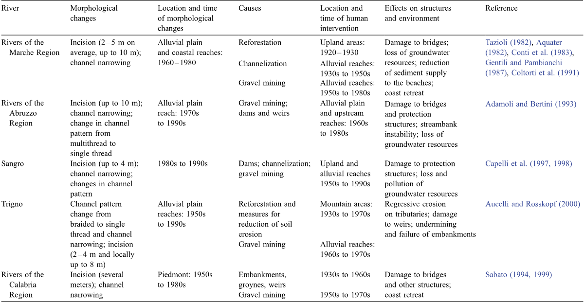
Table 2 Recent channel adjustments in Italian rivers and relative causes and effects 
Fig. 2. Channel incision along the Arno River in the Lower Valdarno–Pisa Plain reach. (A) Example of typical change in cross section, with limited bed lowering from 1936 to 1954, and intense incision from 1954 to 1978. Total bed level lowering from 1844 to 1978 was 6.3 m. (B) Bridge 2 km upstream of the previous section, with exposed piles due to the incision. 
Table 4 (continued ) 
Table 3 (continued ) 
Table 2 Recent channel adjustments in Italian rivers and relative causes and effects 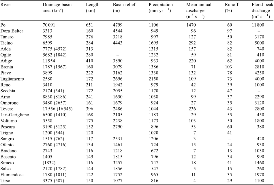
Table 1 Hydrologic and drainage basin characteristics of the main Italian rivers (from Morandini, 1957; Ministero dei Lavori Pubblici—Servizio Idrografico, 1980; Cati, 1981; Tonini, 1983) 
Table 4 (continued ) 
Fig. 1. Location map to show the main Italian rivers (see Table 1 for their hydrologic and drainage basin characteristics). Inset: Regions of Italy. Valle d’Aosta (VA), Piedmont (P), Lombardy (L), Trentino Alto Adige (TA), Venetia (V), Friuli Venezia Giulia (FVG), Liguria (LI), Emilia Romagna (ER), Tuscany (T), Umbria (U), Marche (MA), Latium (LA), Abruzzo (A), Molise (M), Campania (C), Apulia (PU), Basilicata (B), Calabria (CA), Sicily (S), Sardinia (SA). 
Fig. 6. Classification scheme of channel adjustments for Italian rivers. Starting from three initial morphologies (A, B and C), different channel adjustments take place due to variable degrees of incision and narrowing.


Citations
785 citations
Cites background from "Morphological response to river eng..."
...Most rivers are no longer free to course across the landscape unimpeded by infrastructure (Surian and Rinaldi 2003; Pinter 2005), and most major rivers no longer exhibit their historic range of flow variability (Postel and Richter 2003; Poff et al....
[...]
...Most rivers are no longer free to course across the landscape unimpeded by infrastructure (Surian and Rinaldi 2003; Pinter 2005), and most major rivers no longer exhibit their historic range of flow variability (Postel and Richter 2003; Poff et al. 2007)....
[...]
567 citations
Cites background from "Morphological response to river eng..."
...2) include contributions by engineers (e.g. Yearke, 1971; Parker and Andres, 1976; Tsujimoto et al., 1980; Surian and Rinaldi, 2003), geomorphologists (e....
[...]
274 citations
269 citations
Cites background from "Morphological response to river eng..."
...Rivers of north-eastern and central Italy A recent review of the effects of river engineering and management on Italian rivers (Surian and Rinaldi, 2003) has shown significant channel adjustments during the last 100 years, mainly incision and channel narrowing....
[...]
...Rivers of north-eastern and central Italy A recent review of the effects of river engineering and management on Italian rivers (Surian and Rinaldi, 2003) has shown significant channel adjustments during the last 100 years, mainly incision and channel narrowing....
[...]
265 citations
References
[...]
2,182 citations
"Morphological response to river eng..." refers background or methods in this paper
...…above can be seen as an application of existing qualitative models of channel adjustments induced by changing discharge and sediment load (e.g. Schumm, 1977; Petts, 1979) to Italian rivers, considering not only the direction of channel changes induced by a disturbance but also, though still…...
[...]
...It is consistent with the model proposed by Schumm (1977), since in the case of a decrease in sediment supply, that model predicts a decrease of channel width, an increase of channel depth, a decrease of gradient, an increase of sinuosity and a decrease of meander wavelength....
[...]
1,210 citations
"Morphological response to river eng..." refers background in this paper
...…channel changes generally take place, such as vertical adjustment, changes in channel width and pattern (e.g. Leopold, 1973; Gregory and Park, 1974; Williams, 1978; Petts, 1979; Williams and Wolman, 1984; Andrews, 1986; Knighton, 1991; Collier et al., 1996; Petit et al., 1996; Kondolf, 1997)....
[...]
1,090 citations
"Morphological response to river eng..." refers background in this paper
...Several studies have analysed the response of rivers to human impact, showing that remarkable channel changes generally take place, such as vertical adjustment, changes in channel width and pattern (e.g. Leopold, 1973; Gregory and Park, 1974; Williams, 1978; Petts, 1979; Williams and Wolman, 1984; Andrews, 1986; Knighton, 1991; Collier et al., 1996; Petit et al., 1996; Kondolf, 1997)....
[...]
...…channel changes generally take place, such as vertical adjustment, changes in channel width and pattern (e.g. Leopold, 1973; Gregory and Park, 1974; Williams, 1978; Petts, 1979; Williams and Wolman, 1984; Andrews, 1986; Knighton, 1991; Collier et al., 1996; Petit et al., 1996; Kondolf, 1997)....
[...]
...5 to 3 m); channel narrowing by direct river regulation works and by intense sedimentation in the inter-embankment zones Alterations in agricultural practices and regulation of mountain streams; river-control works; gravel extraction Wyzga (1993), Lajczak (1995), Lach and Wyzga (2002)...
[...]
...Numerous examples in the literature report how bed-level changes at a site are best described mathematically by non-linear functions, where adjustments occur rapidly, immediately after the disturbance, and then slow and become asymptotic (Graf, 1977; Williams and Wolman, 1984; Simon and Hupp, 1986)....
[...]
459 citations
425 citations
"Morphological response to river eng..." refers background in this paper
...Within this context, an exception is represented by the Tagliamento River (Eastern Alps) that can be considered the last large river in the Alps essentially retaining pristine morphological and ecological characters (Ward et al., 1999; Gurnell et al., 2001)....
[...]