scispace - formally typeset
Open AccessBook ChapterDOI

Online Reconstruction Of Vehicles In A Car Park

Reads0
Chats0
TLDR
A method of obtaining vehicle hypothesis based on laser scan data only is proposed and implemented on the robotic vehicle, CyCab, for navigation and mapping of the static car park environment.
Abstract
In this paper, a method of obtaining vehicle hypothesis based on laser scan data only is proposed This is implemented on the robotic vehicle, CyCab, for navigation and mapping of the static car park environment Laser scanner data is used to obtain hypothesis on position and orientation of vehicles with Bayesian Programming Using the hypothesized vehicle poses as landmarks, CyCab performs Simultaneous Localization And Mapping (SLAM) A final map consisting of the vehicle positions in the car park is obtained

read more

Content maybe subject to copyright    Report

HAL Id: inria-00182042
https://hal.inria.fr/inria-00182042
Submitted on 24 Oct 2007
HAL is a multi-disciplinary open access
archive for the deposit and dissemination of sci-
entic research documents, whether they are pub-
lished or not. The documents may come from
teaching and research institutions in France or
abroad, or from public or private research centers.
L’archive ouverte pluridisciplinaire HAL, est
destinée au dépôt et à la diusion de documents
scientiques de niveau recherche, publiés ou non,
émanant des établissements d’enseignement et de
recherche français ou étrangers, des laboratoires
publics ou privés.
Online Reconstruction Of Vehicles In A Car Park
Christopher Tay, Cédric Pradalier, Christian Laugier
To cite this version:
Christopher Tay, Cédric Pradalier, Christian Laugier. Online Reconstruction Of Vehicles In A Car
Park. Proc. of the Int. Conf. on Field and Service Robotics, Jul 2005, Port Douglas Australia,
Australia. pp.207-218, �10.1007/978-3-540-33453-8_18�. �inria-00182042�

On-Line Reconstruction of Vehicles In A Car
Park
Christopher Tay Meng Keat
1
, edric Pradalier
2
, and Christian Laugier
3
1
INRIA Rhˆone Alpes GRAVIR Laboratory tay@inrialpes.fr
2
CSIRO ICT Center, Canberra-Australia cedric.pradalier@csiro.au
3
INRIA Rhˆone Alpes GRAVIR Laboratory christian.laugier@inrialpes.fr
Summary. In this paper, a method of obtaining vehicle hypothesis based on laser
scan data only is proposed. This is implemented on the robotic vehicle, CyCab,
for navigation and mapping of the static car park environment. Laser scanner data
is used to obtain hypothesis on position and orientation of vehicles with Bayesian
Programming. Using the hypothesized vehicle poses as landmarks, CyCab performs
Simultaneous Localization And Mapping (SLAM). A final map consisting of the
vehicle positions in the car park is obtained.
Key words: Vehicle Detection, Bayesian Programming
1 Introduction
In the framework of automatic vehicles in car parks, a 2D map of a car park
is constructed using the autonomous vehicle, CyCab, as the experimental
platform. The map of the car park will contain the positions and orientations
of the different vehicles in the car park. An application of such a map is to
serve as a reference to indicate obstacle positions . Furthermore, it can indicate
the state of the parking lots in the car park, and possibly be used in higher
level applications such as automatic parking.
Several object based representation of the environment were proposed.
Chatila et al. [8] represented the map with a set of lines. More advanced
methods in mapping consists of approximating the environment using small
polygons [3] [4]. Such methods used a variant of the Expectation-Maximization
to generate increasingly accurate 3D maps as more observations are made.
In this paper, a higher level of representation (vehicles in this case) of the
environment is used instead of fundamental geometrical entities.
Currently, the CyCab robotic vehicle localizes itself in a static environemnt
with respect to artificially installed reflective cones. This localization serves to
build a grid map of the environment and has the capability to perform motion
planning with safe navigation as described in [1]. However, reflective cones as

2 Christopher Tay Meng Keat, edric Pradalier, and Christian Laugier
artifical landmarks is not a very practical approach. An improvement from an
application point of view is to use naturally occuring objects often found in
the car park as landmarks. In this paper, vehicles found in the car park are
used.
The general idea is to use only the laser data without artificial or predefined
landmarks, CyCab will navigate the car park autonomously while generating
a map of its environment.While CyCab is travelling around the car park,
scanning the environment, CyCab continuously reads in odometric and laser
data. At each stage of the iteration, CyCab estimates its own position and
orientation of the form (x, y, θ) and creates a map of the car park in the world
frame of reference. The origin of the world frame of reference is taken from
the initial position of CyCab. The map is then represented as a set of tuples,
each containing the position and orientation of the vehicles detected. CyCab
hypothesizes the configuration of the vehicles in the surrounding based on the
laser scan inputs from laser scanner only.
The advantage of the approach is its ability to map any car park without
installing any external aids. With the set of vehicle poses representing the
map, a compact and semantic representation of the map can be obtained.
2 System Overview
The mechanism of the entire system can be broken down into three funda-
mental components, vehicle detection, the simultaneous localization and map-
ping(slam) and the map construction . CyCab is provided with two types of
raw data, the laser scans and CyCab’s odometric data. Figure 1 shows the
block diagram of the different stages and its interactions:
Data
Laser
Raw
Positions
Vehicle
Relative
Positions
Vehicle
Absolute
Map
Hypothesized
Robot Localization
Vehicle Odometry
Detection
Vehicle
SLAM
Map
Construction
Fig. 1. Overview showing the mapping process
1. Vehicle Detection: With only raw laser scan data, vehicle detection
constructs hypotheses about the positions and orientation of vehicles in
the car park.
2. SLAM: Coupled with information about odometry of CyCab, SLAM
module makes use of the constructed vehicle hypotheses as landmarks

On-Line Reconstruction of Vehicles In A Car Park 3
to localize itself. With its own configuration, SLAM can then calculate
the absolute configuration of the vehicles with respect to real world coor-
dinates.
3. Map Construction: The hypotheses of vehicles have to be checked for
inconsistencies. It is possible for the hypotheses obtained to conflict with
a previous corresponding hypothesis. Furthermore, multiple hypothesis
SLAM methods such as FastSLAM produces a set of hypotheses, a map
construction module is required to merge the information from the differ-
ent hypotheses to obtain the final map.
3 Vehicle Detection
Vehicle detection is the process of forming possible vehicle hypotheses based
on the laser data readings. This problem is addressed in this paper using
bayesian programming[2]. Bayesian programs provides us with a framework
for encoding our a priori knowledge on the vehicle to infer the possible vehicle
poses. In this case, the a priori knowledge consists of the length and width
of vehicles which is assumed to be the same across standard vehicles (cars)
and that the type of vehicles in the car park is of the same class. The subtle
differences in the size of the vehicles can be accomodated for in the bayesian
paradigm and this property renders our assumption practical.
The detection of vehicles takes place in two stages. The first stage is basi-
cally composed of three portions:
1. Clustering and segmentation, to group a set of points indicating ob-
jects, using a distance criterion. Next, segments are obtained using clas-
sical split and merge techniques.
2. Vehicle hypotheses construction using bayesian programming. The
construction of hypotheses by bayesian programming results in a mech-
anism similar to that of hough transform. Peak values in the histogram
indicates the most probable vehicle poses.
With real data, the first stage produces too many false positives. A second
stage of filtering is applied to each vehicle hypothesis obtained after the first
stage as a form of validation gating in order to reduce the number of false
positives. It is broken down into two portions:
1. Edge Filtering is applied to extract the set of line segments that is only
relevant to the vehicle hypothesis in question.
2. Vehicle Support Filtering is based on our proposed metric, vehicle
support, that measures how much of the two adjacent sides of a vehicle
are seen. We try to remove as many false positives as possible using the
vehicle support.

4 Christopher Tay Meng Keat, edric Pradalier, and Christian Laugier
3.1 Construction of vehicle hypotheses
A bayesian program is used to infer vehicle positions. The formulation of our
bayesian program results in a mechanism similar to that of a hough transform.
We can infer on positions and orientations of vehicles from segments detected
from laser scan data which is analogous to the way line segments are recovered
from an ensemble of points. However our histogram cells are updated in terms
of probability which takes into account the length and the width of vehicles
instead of voting in the case of hough transform.
Briefly, a bayesian program is composed of:
the list of relavant variables;
a decomposition of the joint distribution over these variables;
the parametrical form of each factor of the decomposition;
the identification of the parameters of these parametrical forms;
a question in the form of probability distribution inferred from the joint
distribution.
In the construction of the histogram, each line segment is treated inde-
pendently. In doing so, it will be sufficient to simply go through the list of
segments and add necessary information into the histogram for each line seg-
ment. This is achieved by performing data fusion with diagnostic [7]. Inference
of vehicle poses is represented by the bayesian program in fig. 2 and fig. 3. In
this paper, the following variables are adopted:
V : A boolean value indicating the presence of a vehicle
Z = (x, y, θ): The pose of a vehicle
S: Ensemble of extracted line segments
M {0, 1}
p
: Compatibility of segments with vehicle pose
C {1, 2}
p
: A value of 1 or 2 if segment corresponds to the width and
length of a vehicle respectively
π: A priori knowledge
To represent the absence of specific knowledge on the presence of vehicle
P (V | π
f
), the pose of the vehicle P (Z | π
f
) and the segments P (S | π
f
), they
are represented as a uniform distribution.
The semantic of the question from the bayesian program (fig. 2) is to
find the probability of a vehicle given all segments and the vehicle pose. This
question can be simplified using baye’s rule:
P ([V = 1] | [M = 1] [S] Z π
f
)
= K
Y
i
P ([M
i
= 1] | [V = 1] Z S
i
π
f
)
With K constant. The simplification of the question gives the product of the
probability of the contributions of each line segment, which is given by each
sensor sub-model. The local maximas of the function, P ([V = 1]|[M = 1] [S =

Citations
More filters
Dissertation

Autonomous Mobile Systems for Long-Term Operations in Spatio-Temporal Environments

TL;DR: This document reports on research conducted between 2001 and 2015 in the field of field robotics, specifically in what became known “field robotics”: a focus of robotics on outdoor, little-structured environments close to industrial applications.
References
More filters
Proceedings ArticleDOI

Real-time acquisition of compact volumetric 3D maps with mobile robots

TL;DR: This work describes an online algorithm for generating compact 3D maps of mobile robot environments that builds on the expectation maximization algorithm, but develops a new, incremental version that can be executed in real-time.
Proceedings ArticleDOI

Vehicle detection and car park mapping using laser scanner

TL;DR: The key contribution of the paper is the extraction of vehicle poses from the line segments using Bayesian programming, which is used in localizing CyCab and estimating the pose of vehicles in the car park.
Proceedings ArticleDOI

Expressing Bayesian fusion as a product of distributions: applications in robotics

TL;DR: This paper studies various fusion schemes and proposes to add consistency variable to justify the use of a product to compute distribution over the fused variable and shows application of this new fusion process to localization of a mobile robot and obstacle avoidance.
Proceedings ArticleDOI

An autonomous car-like robot navigating safely among pedestrians

TL;DR: This paper addresses the fusion of controls issued from the control law and the obstacle avoidance module using probabilistic techniques and aims at reactive execution of planned motion in bi-steerable car.
Related Papers (5)
Frequently Asked Questions (16)
Q1. What contributions have the authors mentioned in the paper "Online reconstruction of vehicles in a car park" ?

Tay et al. this paper presented an online reconstruction of vehicles in a car park using laser scan data. 

A second stage of filtering is applied to each vehicle hypothesis obtained after the first stage as a form of validation gating in order to reduce the number of false positives. 

In this paper, a higher level of representation (vehicles in this case) of the environment is used instead of fundamental geometrical entities. 

The general idea is to use only the laser data without artificial or predefined landmarks, CyCab will navigate the car park autonomously while generating a map of its environment. 

A metric, the vehicle support, based on the sum of the magnitude of cross products can be used to enforce their conservative approach. 

The disadvantage of the vehicle pose hypotheses construction and conservative gating approach is its inability to handle occlusion and false positives are obtained as a result. 

The two main criteria for measuring similarity of a current hypothesis and a previously accepted hypothesis are their position and angle. 

The current implementation is a naive and unoptimized version of FastSLAM that executes with a frequency of between 4-6Hz on a pentium 4. 

a bayesian program is composed of:• the list of relavant variables ; • a decomposition of the joint distribution over these variables; • the parametrical form of each factor of the decomposition; • the identification of the parameters of these parametrical forms; • a question in the form of probability distribution inferred from the jointdistribution. 

The authors can infer on positions and orientations of vehicles from segments detected from laser scan data which is analogous to the way line segments are recovered from an ensemble of points. 

The equation for calculating the support is given by:support = ∀i, j ∑i6=j| Si × Sj | (1)Intuitively, if a large portion of the length and a small portion of the width is detected, the support will give a low value and vice versa. 

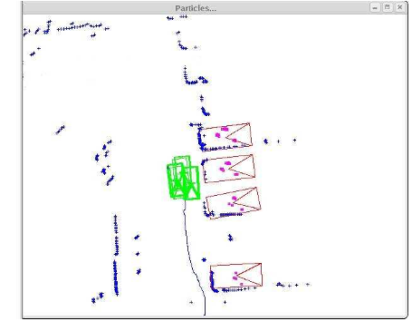
7. Due to the conservative approach in validating hypotheses in stage 2, some potential hypotheses are inevitably eliminated in the process (eliminated vehicle hypothesis to the right in fig. 

Two bounding rectangles are calculated from the vehicle hypothesis configuration with one rectangle a ratio smaller than the original vehicle size and the other a ratio bigger as illustrated in figure 4. 

The most likely group of hypotheses with the same data association for a given observation can be combined together to obtain the landmark to be represented in thefinal map while the rest of the hypotheses are ignored. 

LGiven the length L and the width l of the assumed vehicle size, the authors consider the prior probability that the segment belongs to either the length or width is based on the simple ratio of the side in question against the sum of the two sides. 

The mechanism of the entire system can be broken down into three fundamental components, vehicle detection, the simultaneous localization and mapping(slam) and the map construction .