scispace - formally typeset
Search or ask a question
Proceedings ArticleDOI

Sensor deployment and target localization based on virtual forces

09 Jul 2003-Vol. 2, pp 1293-1303
TL;DR: A virtual force algorithm (VFA) is proposed as a sensor deployment strategy to enhance the coverage after an initial random placement of sensors to improve the coverage of cluster-based distributed sensor networks.
Abstract: The effectiveness of cluster-based distributed sensor networks depends to a large extent on the coverage provided by the sensor deployment. We propose a virtual force algorithm (VFA) as a sensor deployment strategy to enhance the coverage after an initial random placement of sensors. For a given number of sensors, the VFA algorithm attempts to maximize the sensor field coverage. A judicious combination of attractive and repulsive forces is used to determine virtual motion paths and the rate of movement for the randomly-placed sensors. Once the effective sensor positions are identified, a one-time movement with energy consideration incorporated is carried out, i.e., the sensors are redeployed to these positions. We also propose a novel probabilistic target localization algorithm that is executed by the cluster head. The localization results are used by the cluster head to query only a few sensors (out of those that report the presence of a target) for more detailed information. Simulation results are presented to demonstrate the effectiveness of the proposed approach.

Summary (4 min read)

Introduction

  • Sensor coverage, distributed sensor networks, sensor placement, virtual force, localization.
  • During the execution of the force-directed VFA algorithm, sensors do not physically move but a sequence of virtual motion paths is determined for the randomly-placed sensors.
  • The cluster head subsequently queries a subset of sensors that are in the vicinity of these likely target positions.
  • In Section II, the authors review prior research on topics related to sensor deployment in DSNs.

A. Preliminaries

  • For a cluster-based sensor network architecture, the authors make the following assumptions: After the initial random deployment, all sensor nodes are able to communicate with the cluster head.
  • In addition to the positive and negative forces due to other sensors, a sensor si is also subjected to forces exerted by obstacles and areas of preferential coverage in the grid.
  • When sensor detection areas overlap, the closer the sensors are to each other, the higher is the coverage probability for grid points in the overlapped areas.
  • The coverage for the entire grid is calculated as the fraction of grid points that exceeds the threshold cth.
  • Fig. 7 shows the data structure of the VFA algorithm and Fig. 8 shows the implementation details.

IV. TARGET LOCALIZATION

  • In their two-step communication protocol, when a sensor detects a target, it sends an event notification to the cluster head.
  • In order to conserve power and bandwidth, the message from the sensor to the cluster head is kept very small; in fact, the presence or absence of a target can be encoded in just one bit.
  • Detailed information such as detection strength level, imagery and time series data are stored in the local memory and provided to the cluster head upon subsequent queries.
  • Based on the information received from the sensors within the cluster, the cluster head executes a probabilistic localization algorithm to determine candidate target locations, and it then queries the sensor(s) in the vicinity of the target.
  • The authors assume here that the sensor detection reports are time-labeled.

A. Detection Probability Table

  • After the VFA algorithm is used to determine the final sensor locations, the cluster head generates a detection probability table for each grid point.
  • The detection probability table contains entries for all possible detection reports from those sensors that can detect a target at this grid point.
  • The probability table is built on the power set of Sxy since there are 2kxy possibilities for kxy sensors in reporting an event.
  • The binary string 110 denotes the possibility that s1 and s2 report a target but s3 does not report a target.
  • For each such possibility d1d2d3 (d1, d2, d3 ∈ {0, 1}) for a grid point, the authors calculate the conditional probabilities that the cluster head receives d1d2d3 given that a target is present at that grid point.

B. Score-based Ranking

  • After the probability table is generated for all the grid points, localization is done by the cluster head if a target is detected by one or more sensors.
  • Detailed target reporting involves sending large amount of data, which consumes more energy consumption and needs more bandwidth.
  • There is also an inherent redundancy in sensor detection information so it is not necessary to query all sensors.
  • The target starts to move at t = tstart from the grid point marked as “Start” and finishes at t = tend at the grid point marked as “End”.
  • The parameter p tablexy(i(t)) corresponds to the conditional probability that the cluster head receives this event information given that there was a target at P (x, y).

C. Selection of Sensors to Query

  • To select the sensor to query based on the event reports and the localization procedure, the authors first note that for time instant t, if kmax ≥ krep(t), then all reported sensors can be queried.
  • Otherwise, the authors select sensors based on a score-based ranking.
  • For the example of Fig. 10, Table II shows the selected sensor when the target is moving from “Start” to “End”.
  • There are total of 24 locations for the target.
  • The authors also assume the time instants are discrete, beginning with t = 1.

D. Evaluation of Energy Savings

  • The authors next evaluate the energy saved by the proposed probabilistic localization approach.
  • Assume the sensor node has three basic energy consumption types—sensing, transmitting and receiving, and these power values (energy per unit time) are Es, Et and Er, respectively.
  • The parameters T1, T2 and T3 denote the lengths of time involved in the transmission and reception, which are directly proportional to the sizes of data for yes/no messages, control messages to query sensors, and the detailed sensor data transmitted to the cluster head.
  • Fig. 12 shows the pseudocode of the procedure to generate the probability table for each grid point.
  • Therefore, the computational complexity of the probabilistic localization algorithm is max{O, O(nm2k)} = O(nm2k).

V. SIMULATION RESULTS

  • The authors first present simulation results obtained using the VFA algorithm.
  • Then the simulation results of the probabilistic localization algorithm are presented using the sensor location data from the VFA algorithm as inputs.
  • The deployment requirements include the maximum improvement of coverage over random deployment, the coverage for preferential areas and the avoidance of obstacles.
  • For all simulation results presented in this section, distances are measured in units of grid points.
  • Each sensor has a detection radius as 5 units (r = 5), and range detection error as 3 units (re = 3) for the probabilistic detection model.

A. Case Study 1: Binary Sensor Detection Model

  • Figures 14-16 present simulation results based on the binary sensor detection model.
  • The initial locations of the sensors are shown in Fig. 14.
  • For the binary sensor detection model, an upper bound on the coverage is given by the ratio of the sum of the circle areas (corresponding to sensors) to the total area of the sensor field.
  • For their example, this upper bound evaluates to 0.628 and it is achieved after 28 iterations of the VFA algorithm.
  • Fig. 16 shows the improvement in coverage during the execution of the VFA algorithm.

B. Case Study 2: Probabilistic Sensor Detection Model

  • Figures 17-19 present simulation results for the probabilistic sensor model.
  • The initial sensor placements are shown in Fig. 17.
  • Fig. 18 shows the final sensor positions determined by the VFA algorithm.
  • Fig. 19 shows the virtual movement traces of all sensors during the execution of the VFA algorithm.
  • The authors can see overlap areas are used to increase the number of grid points whose coverage exceeds the required threshold cth.

C. Case Study 3: Sensor Field with a Preferential Area and an Obstacle

  • As discussed in Section III, VFA is also applicable with sensor field containing obstacles and preferential areas.
  • Obstacles should be avoided, therefore they are modeled as repulsive force sources in the VFA algorithm.
  • Fig. 20-22 present simulation results for a 50 by 50 sensor field that contains an obstacle and a preferential area.
  • The initial sensor placements are shown in Fig. 20.
  • Fig. 22 shows the improvement of coverage during the execution of the VFA algorithm.

D. Case Study 4: Probability-based Target Localization

  • The authors evaluate the localization algorithm using the results produced by the VFA algorithm in the sensor deployment stage.
  • At this stage, sensors are already moved to proper locations by the VFA algorithm.
  • The target is assumed to move only 1 grid unit in one unit of time.
  • There are total of 82 such moves in the simulated target movement trace.
  • The set Srep(t) indicates sensors that have reported the detection at time instant t. The set Sq(t) includes sensors that are selected for querying by the cluster head at time t.

E. Discussion

  • From the simulation results, the authors see that the VFA algorithm improves the sensor field coverage considerably compared to random sensor placement, and it does not require much computation time.
  • For Case Study 2, the VFA algorithm took only 3 minutes to complete 50 iterations.
  • Note that these computation time include the time needed for displaying the simulation results on the screen.
  • The efficiency of the VFA algorithm depends on the values of the force parameters wA and wR.
  • This need not always be true, so the authors are examining ways to choose appropriate values for wR and wA base on the initial configuration.

VI. CONCLUSION

  • The authors have proposed the virtual force algorithm (VFA) as a practical approach for sensor deployment.
  • The authors have also shown that the proposed probabilistic localization algorithm can significantly reduce the energy consumption for target detection and location.
  • The VFA algorithm can be made more efficient if it is provided with the theoretical bounds on the number of sensors needed to achieve a given coverage threshold.
  • Finally, the authors will examine continuous coordination systems instead of discrete coordination systems in this work.

Did you find this useful? Give us your feedback

Figures (23)

Content maybe subject to copyright    Report

Sensor Deployment and Target Localization Based
on Virtual Forces
Yi Zou and Krishnendu Chakrabarty
Abstract The effectiveness of cluster-based distributed sensor
networks depends to a large extent on the coverage provided by
the sensor deployment. We propose a virtual force algorithm
(VFA) as a sensor deployment strategy to enhance the coverage
after an initial random placement of sensors. For a given
number of sensors, the VFA algorithm attempts to maximize
the sensor field coverage. A judicious combination of attractive
and repulsive forces is used to determine virtual motion paths
and the rate of movement for the randomly-placed sensors. Once
the effective sensor positions are identified, a one-time movement
with energy consideration incorporated is carried out, i.e., the
sensors are redeployed to these positions. We also propose a novel
probabilistic target localization algorithm that is executed by the
cluster head. The localization results are used by the cluster head
to query only a few sensors (out of those that report the presence
of a target) for more detailed information. Simulation results
are presented to demonstrate the effectiveness of the proposed
approach.
Index Terms Sensor coverage, distributed sensor networks,
sensor placement, virtual force, localization.
I. INTRODUCTION
Distributed sensor networks (DSNs) are important for a
number of strategic applications such as coordinated target
detection, surveillance, and localization. The effectiveness of
DSNs is determined to a large extent by the coverage provided
by the sensor deployment. The positioning of sensors affects
coverage, communication cost, and resource management.
In this paper, we focus on sensor placement strategies that
maximize the coverage for a given number of sensors within
a cluster in cluster-based DSNs.
As an initial deployment step, a random placement of
sensors in the target area (sensor field) is often desirable,
especially if no aprioriknowledge of the terrain is available.
Random deployment is also practical in military applications,
where DSNs are initially established by dropping or throwing
sensors into the sensor field. However, random deployment
does not always lead to effective coverage, especially if the
sensors are overly clustered and there is a small concentration
of sensors in certain parts of the sensor field. The key idea
of this paper is that the coverage provided by a random
deployment can be improved using a force-directed algorithm.
Y. Zou and K. Chakrabarty are with the Department of Electrical and
Computer Engineering, Duke University, Durham, NC 27708, USA. E-mail:
{yz1, krish}@ee.duke.edu.
This research was supported in part by ONR under grant no. N66001-
00-1-8946. It was also sponsored in part by DARPA, and administered
by the Army Research Office under Emergent Surveillance Plexus MURI
Award No. DAAD19-01-1-0504. Any opinions, findings, and conclusions or
recommendations expressed in this publication are those of the authors and
do not necessarily reflect the views of the sponsoring agencies.
We present the virtual force algorithm (VFA) as a sensor
deployment strategy to enhance the coverage after an initial
random placement of sensors. The VFA algorithm is inspired
by disk packing theory [11] and the virtual force field concept
from robotics [5]. For a given number of sensors, VFA
attempts to maximize the sensor field coverage using a combi-
nation of attractive and repulsive forces. During the execution
of the force-directed VFA algorithm, sensors do not physically
move but a sequence of virtual motion paths is determined
for the randomly-placed sensors. Once the effective sensor
positions are identified, a one-time movement is carried out
to redeploy the sensors at these positions. Energy constraints
are also included in the sensor repositioning algorithm.
We also propose a novel target localization approach based
on a two-step communication protocol between the cluster
head and the sensors within the cluster. In the first step,
sensors detecting a target report the event to the cluster head.
The amount of information transmitted to the cluster head is
limited; in order to save power and bandwidth, the sensor
only reports the presence of a target, and it does not transmit
detailed information such as signal strength, confidence level
in the detection, imagery or time series data. Based on the
information received from the sensor and the knowledge of
the sensor deployment within the cluster, the cluster head
executes a probabilistic scoring-based localization algorithm
to determine likely position of the target. The cluster head
subsequently queries a subset of sensors that are in the vicinity
of these likely target positions.
The sensor field is represented by a two-dimensional grid.
The dimensions of the grid provide a measure of the sensor
field. The granularity of the grid, i.e. distance between grid
points can be adjusted to trade off computation time of the
VFA algorithm with the effectiveness of the coverage measure.
The detection by each sensor is modeled as a circle on the
two-dimensional grid. The center of the circle denotes the
sensor while the radius denotes the detection range of the
sensor. We first consider a binary detection model in which
a target is detected (not detected) with complete certainty by
the sensor if a target is inside (outside) its circle. The binary
model facilitates the understanding of the VFA model. We
then investigate a realistic probabilistic model in which the
probability that the sensor detects a target depends on the
relative position of the target within the circle. The details
of the probabilistic model are presented in Section III.
The organization of the paper is as follows. In Section II, we
review prior research on topics related to sensor deployment
in DSNs. In Section III, we present details of the VFA
algorithm. In Section IV, we present the target localization
0-7803-7753-2/03/$17.00 (C) 2003 IEEE IEEE INFOCOM 2003

algorithm that is executed by the cluster head. In Section
V, we present simulation results using the proposed sensor
deployment strategy for various situations. Section VI presents
conclusions and outlines directions for future work.
II. R
ELATED PRIOR WORK
Sensor deployment problems have been studied in a variety
of contexts [1], [2], [9]. In the area of adaptive beacon
placement and spatial localization, a number of techniques
have been proposed for both fine-grained and coarse-grained
localization [12].
Sensor deployment and sensor planning for military appli-
cations are described in [6], where a general sensor model
is used to detect elusive targets in the battlefield. However,
the proposed DSN framework in [6] requires a great deal of
aprioriknowledge about possible targets. Hence it is not
applicable in scenarios where there is no information about
potential targets in the environment.
The deployment of sensors for coverage of the sensing field
has been considered for multi-robot exploration [5]. Each robot
can be viewed as a sensor node in such systems. An incre-
mental deployment algorithm is used in which sensor nodes
are deployed one by one in an adaptive fashion. A drawback
of this approach is that it is computationally expensive. As the
number of sensors increases, each new deployment results in
a relatively large amount of computation.
The problem of evaluating the coverage provided by a given
placement of sensors is discussed in [7]. The major concern
here is the self-localization of sensor nodes; sensor nodes are
considered to be highly mobile and they move frequently. An
optimal polynomial-time algorithm that uses graph theory and
computational geometry constructs is used to determine the
best-case and the worst-case coverage.
Radar and sonar coverage also present several related chal-
lenges [13]. Radar and sonar netting optimization are of great
importance for detection and tracking in a surveillance area.
Based on the measured radar cross-sections and the coverage
diagrams for the different radars, the authors in [13] propose a
method for optimally locating the radars to achieve satisfactory
surveillance with limited radar resources.
Sensor placement on two- and three-dimensional grids has
been formulated as a combinatorial optimization problem, and
solved using integer linear programming in [3], [4]. This
approach suffers from two main drawbacks. First, compu-
tational complexity makes the approach infeasible for large
problem instances. Second, the grid coverage approach relies
on “perfect” sensor detection, i.e. a sensor is expected to yield
a binary yes/no detection outcome in every case. However,
because of the inherent uncertainty associated with sensor
readings, sensor detection must be modeled probabilistically
[10].
A probabilistic optimization framework for minimizing the
number of sensors for a two-dimensional grid has been pro-
posed recently [10]. This algorithm attempts to maximize the
average coverage of the grid points. Finally, there exists a
close resemblance between the sensor placement problem and
the art gallery problem (AGP) addressed by the art gallery
theorem [14]. Other related work includes the placement of a
given number of sensors to reduce communication cost [15],
optimal sensor placement for a given target distribution [16].
Our proposed algorithm differs from prior methods in
several ways. First, we consider both the binary sensor de-
tection model and probabilistic detection model to handle
sensors with both high and low detection accuracy. Second,
the amount of computation is limited since we perform a
one-time computation and sensor locations are determined at
the same time for all the sensor nodes. Third, our approach
improves upon an initial random placement, which offers a
practical sensor deployment solution. Finally, we investigate
the relationship between sensor placement within a cluster and
target localization by the cluster head.
III. V
IRTUAL FORCE ALGORITHM
In this section, we describe the underlying assumptions and
the virtual force algorithm (VFA).
A. Preliminaries
For a cluster-based sensor network architecture, we make
the following assumptions:
After the initial random deployment, all sensor nodes are
able to communicate with the cluster head.
The cluster head is responsible for executing the VFA al-
gorithm and managing the one-time movement of sensors
to the desired locations.
In order to minimize the network traffic and conserve
energy, sensors only send a yes/no notification message
to the cluster head when a target is detected. The cluster
head intelligently queries a subset of sensors to gather
more detailed target information.
The VFA algorithm combines the ideas of potential field [5]
and disk packing [11]. In the sensor field, each sensor behaves
as a “source of force” for all other sensors. This force can
be either positive (attractive) or negative (repulsive). If two
sensors are placed too close to each other, the “closeness”
being measured by a pre-determined threshold, they exert
negative forces on each other. This ensures that the sensors are
not overly clustered, leading to poor coverage in other parts of
the sensor field. On the other hand, if a pair of sensors is too
far apart from each (once again a pre-determined threshold
is used here), they exert positive forces on each other. This
ensures that a globally uniform sensor placement is achieved.
Consider an n by m sensor field grid and assume that
there are k sensors deployed in the random deployment stage.
Each sensor has a detection range r. Assume sensor s
i
is
deployed at point (x
i
,y
i
). For any point P at (x, y),we
denote the Euclidean distance between s
i
and P as d(s
i
,P),
i.e. d(s
i
,P)=
(x
i
x)
2
+(y
i
y)
2
. Equation (1) shows
the binary sensor model [3], [4] that expresses the coverage
c
xy
(s
i
) of a grid point P by sensor s
i
.
c
xy
(s
i
)=
1, if d(s
i
,P) <r
0, otherwise.
(1)
The binary sensor model assumes that sensor readings have
no associated uncertainty. In reality, sensor detections are
0-7803-7753-2/03/$17.00 (C) 2003 IEEE IEEE INFOCOM 2003

imprecise, hence the coverage c
xy
(s
i
) needs to be expressed
in probabilistic terms. In this work, we assume the following,
motivated in part by [8]:
c
xy
(S
i
)=
0, if r + r
e
d(s
i
,P)
e
λa
β
, if r r
e
<d(s
i
,P) <r+ r
e
1, if r r
e
d(s
i
,P)
(2)
where r
e
(r
e
<r) is a measure of the uncertainty in sensor
detection, a = d(s
i
,P)(rr
e
), and α and β are parameters
that measure detection probability when a target is at distance
greater than r
e
but within a distance from the sensor. This
model reflects the behavior of range sensing devices such as
infrared and ultrasound sensors. The probabilistic sensor detec-
tion model is shown in Fig. 1. Note that distances are measured
in units of grid points. Fig. 1 also illustrates the translation of
a distance response from a sensor to the confidence level as a
probability value about this sensor response. Different values
of the parameters α and β yield different translations reflected
by different detection probabilities, which can be viewed as
the characteristics of various types of physical sensors.
0 1 2 3 4 5 6 7 8 9 10
0
0.1
0.2
0.3
0.4
0.5
0.6
0.7
0.8
0.9
1
Distance d(S
i
, P) between sensor and grid point
Detection probability
λ=0.5, β=1
λ=1, β=0.5
λ=0.5, β=0.5
λ=1, β=1
Fig. 1. Probabilistic sensor detection model.
B. Virtual Forces
We now describe the virtual forces and virtual force calcu-
lation in the VFA algorithm. In the following discussion, we
use the notation introduced in the previous subsection. Let the
total force action on sensor s
i
be denoted by
F
i
. Note that
F
i
is a vector whose orientation is determined by the vector sum
of all the forces acting on s
i
. Let the force exerted on s
i
by
another sensor s
j
be denoted by
F
ij
.
In addition to the positive and negative forces due to other
sensors, a sensor s
i
is also subjected to forces exerted by
obstacles and areas of preferential coverage in the grid. This
provides us with a convenient method to model obstacles and
the need for preferential coverage. Sensor deployment must
take into account the nature of the terrain, e.g., obstacles
such as building and trees in the line of sight for infrared
sensors, uneven surface and elevations for hilly terrain, etc.
In addition, based on relative measures of security needs and
tactical importance, certain areas of the grid need to be covered
with greater certainty.
In our virtual force model, we assume that obstacles exert
repulsive (negative) forces on a sensor. Likewise, areas of
preferential coverage exert attractive (positive) forces on a
sensor. Let
F
iA
be the total (attractive) force on s
i
due to
preferential coverage areas, and let
F
iR
be the total (repulsive)
force on s
i
due to obstacles. The total force
F
i
on s
i
can now
be expressed as
F
i
=
k
j=1,j=i
F
ij
+
F
iR
+
F
iA
(3)
We next express the force
F
ij
between s
i
and s
j
in polar
coordinate notation. Note that
f =(r, θ) implies a magnitude
of r and orientation θ for vector
f.
F
ij
=
(w
A
(d
ij
d
th
)
ij
) if d
ij
>d
th
0, if d
ij
= d
th
(w
R
1
d
ij
ij
+ π), if otherwise
(4)
where d
ij
is the Euclidean distance between sensor s
i
and
s
j
, d
th
is the threshold on the distance between s
i
and s
j
,
α
ij
is the orientation (angle) of a line segment from s
i
to s
j
,
and w
A
(w
R
) is a measure of the attractive (repulsive) force.
The threshold distance d
th
controls how close sensors get to
each other. As an example, consider the four sensors s
1
, s
2
,
s
3
and s
4
in Fig. 2. The force
F
1
on S
1
is given by
F
1
=
F
12
+
F
13
+
F
14
. If we assume that d
12
>d
th
, d
13
<d
th
,
and d
14
= d
th
, s
2
exerts an attractive force on s
1
, s
3
exerts
a repulsive force on s
1
and s
4
exerts no force on s
1
.Thisis
shown Fig. 2.
Fig. 2. An example of virtual forces with four sensors.
If r
e
0 and we use the binary sensor detection model
given by Equation (1), we attempt to make d
ij
as close to
2r as possible. This ensures that the detection regions of two
sensors do not overlap, thereby minimizing “wasted overlap”
and allowing us to cover a large grid with a small number of
sensors. This is illustrated in Fig. 3(a). An obvious drawback
here is that a few grid points are not covered by any sensor.
0-7803-7753-2/03/$17.00 (C) 2003 IEEE IEEE INFOCOM 2003

Note that an alternative strategy is to allow overlap, as shown
in Fig. 3(b). While this approach ensures that all grid points are
covered, it needs more sensors for grid coverage. Therefore,
we adopt the first strategy. Note that in both cases, the coverage
is effective only if the total area kπr
2
that can be covered with
the k sensors exceeds the area of the grid.
Fig. 3. Non-overlapped and overlapped sensor coverage areas.
If r
e
> 0, r
e
is not negligible and the probabilistic sensor
model given by Equation (2) is used. Note that due to the
uncertainty in sensor detection responses, grid points are not
uniformly covered with the same probability. Some grid points
will have low coverage if they are covered only by only
one sensor and they are far from the sensor. In this case,
it is necessary to overlap sensor detection areas in order to
compensate for the low detection probability of grid points that
are far from a sensor. Consider a grid point with coordinate
(x, y) lying in the overlap region of sensors s
i
and s
j
.Let
c
xy
(s
i
,s
j
) be the probability that a target at this grid point is
reported as being detected by observing the outputs of these
two sensors. We assume that sensors within a cluster operate
independently in their sensing activities. Thus
c
x,y
(s
i
,s
j
)=1 (1 c
x,y
(s
i
))(1 c
x,y
(s
j
)) (5)
where c
xy
(s
i
) and c
xy
(s
j
) were defined in Section 3.1. Since
the term (1 c
x,y
(s
i
))(1 c
x,y
(s
j
)) expresses the probability
that neither s
i
nor s
j
covers grid point at (x, y), the probability
that the grid point (x, y) is covered is given by Equation (5).
Let c
th
be the desired coverage threshold for all grid points.
This implies that
min
x,y
{c
x,y
(s
i
,s
j
)}≥c
th
(6)
Note that Equation (5) can also be extended to a region which
is overlapped by a set of k
ov
sensors, denoted as S
ov
, k
ov
=
|S
ov
|, S
ov
⊆{s
1
,s
2
, ···,s
k
}. The coverage in this case is
given by:
c
x,y
(S
ov
)=1
s
i
S
ov
(1 c
x,y
(s
i
)) (7)
As shown in Equation (4), the threshold distance d
th
is used
to control how close sensors get to each other. When sensor
detection areas overlap, the closer the sensors are to each other,
the higher is the coverage probability for grid points in the
overlapped areas. Note however that there is no increase in the
point coverage once one of the sensors gets close enough to
provide detection with a probability of one. Therefore, we need
to determine d
th
that maximizes the number of grid points
in the overlapped area that satisfies c
xy
(s
i
) >c
th
. Let us
consider the three sensors s
1
, s
2
, and s
3
in Fig. 3(a), where
no overlap exists. Assume the three sensors are on a 31 by
31 grid, r =5and r
e
=3in units of grid points. Figures
4-6 show how the coverage is affected by d
th
and c
th
when
the threshold distance d
th
is changed from r + r
e
to r r
e
.
The coverage for the entire grid is calculated as the fraction
of grid points that exceeds the threshold c
th
.We can use these
graphs to appropriately choose d
th
according to the required
c
th
.
2 3 4 5 6 7 8
0
0.1
0.2
0.3
0.4
0.5
0.6
0.7
0.8
0.9
1
Coverage
c
xy
( S
1
, S
2
) for a sample point
Threshold disctance d
th
, r−r
e
d
th
r+r
e
λ=0.5, β=0.1
λ=0.5, β=0.5
λ=2, β=2
Fig. 4. Coverage vs. d
th
of a sample point inside the overlapped area of s
1
and s
2
.
2 3 4 5 6 7 8
0.02
0.04
0.06
0.08
0.1
0.12
0.14
0.16
0.18
Threshold disctance d
th
, rr
e
d
th
r+r
e
Coverage for the entire grid with
c
th
=0.7
λ=0.5, β=0.1
λ=0.5, β=0.5
λ=2, β=2
Fig. 5. Coverage vs. d
th
with c
th
=0.7 and different λ and β.
In order to prolong battery life, the distances between the
initial and final position of the sensors are limited in the
repositioning phase to conserve energy. We investigated two
approaches for incorporating energy constraints in the VFA
algorithm. The first approach disables any virtual forces on
a sensor whenever the current distance reaches the distance
limit. The second method records all virtual locations that
sensors are moved into during the VFA algorithm. When the
VFA algorithm terminates, a search procedure is used to find
the locations with maximum coverage, except those locations
that are already beyond the distance limit.
Note that the VFA algorithm is designed to be executed on
the cluster head, which is expected to have more computational
0-7803-7753-2/03/$17.00 (C) 2003 IEEE IEEE INFOCOM 2003

2 3 4 5 6 7 8
0.02
0.04
0.06
0.08
0.1
0.12
0.14
0.16
0.18
Threshold disctance d
th
, rr
e
d
th
r+r
e
Coverage percentage of a sample grid,
λ=0.5, β
=0.5
c
th
=0.5
c
th
=0.7
c
th
=0.9
Fig. 6. Coverage vs. d
th
with λ =0.5 and β =0.5 and c
th
=0.5,0.7
and 0.9.
VFA Data Structures: Grid, {s
1
, s
2
, ···, s
k
}
/* n
P
is the number of preferential area blocks (attractive
forces) and n
O
is the number of obstacle blocks (repulsive
forces). S
xy
, k
xy
and p table
xy
are used for localization. */
1 Grid structure:
2 Properties: width, height, k, c
th
, d
th
;
3 Preferential areas: PA
i
(x, y, wx, wy),
i =1, 2, ···,n
P
;
4 Obstacles areas: OA
i
(x, y, wx, wy),
i =1, 2, ···,n
O
;
5 Grid points, P
xy
:
c
xy
(s
1
,s
2
, ···,s
k
), S
xy
,k
xy
,p table
xy
;
6Sensors
i
structure: i, (x, y), r, r
e
, α, β;
Fig. 7. Data structures used in the VFA algorithm.
capabilities than sensor nodes. The cluster head uses the VFA
algorithm to find appropriate sensor node locations based on
the coverage requirements. The new locations are then sent to
the sensor nodes, which perform a one-time movement to the
designated positions. No movements are performed during the
execution of the VFA algorithm.
We next describe the VFA algorithm in pseudo-code form.
Fig. 7 shows the data structure of the VFA algorithm and Fig.
8 shows the implementation details. For a n by m grid with a
total of k sensors deployed, the computational complexity of
the VFA algorithm is O(nmk).
IV. T
ARGET LOCALIZATION
In our two-step communication protocol, when a sensor
detects a target, it sends an event notification to the cluster
head. In order to conserve power and bandwidth, the message
from the sensor to the cluster head is kept very small; in fact,
the presence or absence of a target can be encoded in just
one bit. Detailed information such as detection strength level,
imagery and time series data are stored in the local memory
and provided to the cluster head upon subsequent queries.
Based on the information received from the sensors within the
cluster, the cluster head executes a probabilistic localization
algorithm to determine candidate target locations, and it then
Procedure Virtual Fo rc e Algorithm (Grid, {s
1
, s
2
, ···, s
k
})
1Setloops =0;
2SetMaxLoops =MAX
LOOPS;
3 While (loops < M axLoops)
4 /* coverage evaluation */
5 For P (x, y) in Grid, x [1,width],y [1, height]
6 For s
i
∈{s
1
,s
2
, ···,s
k
}
7 Calculate c
xy
(s
i
,P) from the sensor model
using (d(s
i
,P),c
th
,d
th
);
8 End
9 If coverage requirements are met
10 Break from While loop;
11 End
12 End
13 /* virtual forces among sensors */
14 For s
i
∈{s
1
,s
2
, ···,s
k
}
15 Calculate
F
ij
using d(s
i
,s
j
), d
th
,w
A
,w
R
;
16 Calculate
F
iA
using d(s
i
,PA
1
, ···,PA
n
P
), d
th
;
17 Calculate
F
iR
using d(s
i
,OA
1
, ···,OA
n
O
), d
th
;
18
F
i
=
F
ij
+
F
iR
+
F
iA
,j [1,k],j = i;
19 End
20 /* move sensors virtually */
21 For s
i
∈{s
1
,s
2
, ···,s
k
}
22
F
i
(s
i
) virtually moves s
i
to its next position;
23 End
24 Set loops = loops +1;
25 End
Fig. 8. Pseudocode of the VFA algorithm.
queries the sensor(s) in the vicinity of the target. We assume
here that the sensor detection reports are time-labeled.
A. Detection Probability Table
After the VFA algorithm is used to determine the final
sensor locations, the cluster head generates a detection prob-
ability table for each grid point. The detection probability
table contains entries for all possible detection reports from
those sensors that can detect a target at this grid point. Let
us assume that a grid point P (x, y) is covered by a set of
k
xy
sensors, denoted as S
xy
, |S
xy
| = k
xy
, 0 k
xy
k,
and S
xy
⊆{s
1
,s
2
, ···,s
k
}. The probability table is built on
the power set of S
xy
since there are 2
k
xy
possibilities for k
xy
sensors in reporting an event. These 2
k
xy
cases include the
event that none of the sensors detect anything (represented by
the binary string as “00...0”) as well as the event that all of
the sensors (represented by the binary string as “11...1”). Thus
the probability table for grid point (x, y) then contains 2
k
xy
entries, defined as:
p
table
xy
(i)=
s
j
S
xy
p
xy
(s
j
,i) (8)
where 0 i 2
k
xy
, and p
xy
(s
j
,i)=c
x,y
(s
j
) if s
j
detects
a target at grid point P (x, y); otherwise p
xy
(s
j
,i)=1
c
x,y
(s
j
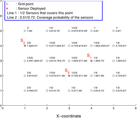
). Table I gives an example of the probability tables on
a 5 by 5 grid with 3 sensors deployed.
Consider the grid point (2, 4) in Fig. 9 which is covered
by all three sensors s
1
,s
2
and s
3
with probabilities as 0.57, 1,
0-7803-7753-2/03/$17.00 (C) 2003 IEEE IEEE INFOCOM 2003

Citations
More filters
Proceedings ArticleDOI
07 Mar 2004
TL;DR: This paper designs two sets of distributed protocols for controlling the movement of sensors, one favoring communication and one favoring movement, and uses Voronoi diagrams to detect coverage holes and use one of three algorithms to calculate the target locations of sensors it holes exist.
Abstract: Sensor deployment is an important issue in designing sensor networks. We design and evaluate distributed self-deployment protocols for mobile sensors. After discovering a coverage hole, the proposed protocols calculate the target positions of the sensors where they should move. We use Voronoi diagrams to discover the coverage holes and design three movement-assisted sensor deployment protocols, VEC (vector-based), VOR (Voronoi-based), and minimax based on the principle of moving sensors from densely deployed areas to sparsely deployed areas. Simulation results show that our protocols can provide high coverage within a short deploying time and limited movement.

946 citations


Cites background from "Sensor deployment and target locali..."

  • ...Index Terms—Mobile sensor networks, sensor coverage, distributed algorithm....

    [...]

Journal ArticleDOI
TL;DR: This paper designs two sets of distributed protocols for controlling the movement of sensors, one favoring communication and one favoring movement, and uses Voronoi diagrams to detect coverage holes and use one of three algorithms to calculate the target locations of sensors it holes exist.
Abstract: -Adequate coverage is very important for sensor networks to fulfill the issued sensing tasks. In many working environments, it is necessary to make use of mobile sensors, which can move to the correct places to provide the required coverage. In this paper, we study the problem of placing mobile sensors to get high coverage. Based on Voronoi diagrams, we design two sets of distributed protocols for controlling the movement of sensors, one favoring communication and one favoring movement. In each set of protocols, we use Voronoi diagrams to detect coverage holes and use one of three algorithms to calculate the target locations of sensors it holes exist. Simulation results show the effectiveness of our protocols and give insight on choosing protocols and calculation algorithms under different application requirements and working conditions.

817 citations

Proceedings ArticleDOI
25 May 2005
TL;DR: This paper studies the dynamic aspects of the coverage of a mobile sensor network that depend on the process of sensor movement, and derives optimal mobility strategies for sensors and targets from their own perspectives.
Abstract: Previous work on the coverage of mobile sensor networks focuses on algorithms to reposition sensors in order to achieve a static configuration with an enlarged covered area. In this paper, we study the dynamic aspects of the coverage of a mobile sensor network that depend on the process of sensor movement. As time goes by, a position is more likely to be covered; targets that might never be detected in a stationary sensor network can now be detected by moving sensors. We characterize the area coverage at specific time instants and during time intervals, as well as the time it takes to detect a randomly located stationary target. Our results show that sensor mobility can be exploited to compensate for the lack of sensors and improve network coverage. For mobile targets, we take a game theoretic approach and derive optimal mobility strategies for sensors and targets from their own perspectives.

582 citations


Cites background from "Sensor deployment and target locali..."

  • ...Permission to make digital or hard copies of all or part of this work for personal or classroom use is granted without fee provided that copies are not made or distributed for pro.t or commercial advantage and that copies bear this notice and the full citation on the .rst page....

    [...]

Proceedings ArticleDOI
13 Mar 2005
TL;DR: A Grid-Quorum solution to quickly locate the closest redundant sensor with low message complexity, and propose to use cascaded movement to relocate the redundant sensor in a timely, efficient and balanced way is proposed.
Abstract: Recently there has been a great deal of research on using mobility in sensor networks to assist in the initial deployment of nodes. Mobile sensors are useful in this environment because they can move to locations that meet sensing coverage requirements. This paper explores the motion capability to relocate sensors to deal with sensor failure or respond to new events. We define the problem of sensor relocation and propose a two-phase sensor relocation solution: redundant sensors are first identified and then relocated to the target location. We propose a Grid-Quorum solution to quickly locate the closest redundant sensor with low message complexity, and propose to use cascaded movement to relocate the redundant sensor in a timely, efficient and balanced way. Simulation results verify that the proposed solution outperforms others in terms of relocation time, total energy consumption, and minimum remaining energy.

536 citations


Cites methods or result from "Sensor deployment and target locali..."

  • ...For example, the work in [ 24 ] assumes that a powerful cluster head is available to collect information and determine the target location of the mobile sensors....

    [...]

  • ...This sensor relocation is different from existing work on mobile sensors which concentrate on sensor deployment; i.e., moving sensors to provide certain initial coverage [11], [12], [20], [21], [ 24 ]....

    [...]

Journal ArticleDOI
TL;DR: The coverage problem is classified from different angles, the evaluation metrics of coverage control algorithms are described, the relationship between coverage and connectivity is analyzed, typical simulation tools are compared, and research challenges and existing problems in this area are discussed.

523 citations


Cites background from "Sensor deployment and target locali..."

  • ...The simulation result of Zou and Chakrabarty (2003) shows that a sensor deployment technique based on virtual forces can increase the area coverage after an initial random deployment....

    [...]

  • ...Zou and Chakrabarty (2003) assumes that obstacles exert repulsive (negative) forces on a sensor....

    [...]

References
More filters
Proceedings ArticleDOI
01 Aug 2000
TL;DR: The randomized algorithm used by beacons to transmit information, the use of concurrent radio and ultrasonic signals to infer distance, the listener inference algorithms to overcome multipath and interference, and practical beacon configuration and positioning techniques that improve accuracy are described.
Abstract: This paper presents the design, implementation, and evaluation of Cricket, a location-support system for in-building, mobile, location-dependent applications. It allows applications running on mobile and static nodes to learn their physical location by using listeners that hear and analyze information from beacons spread throughout the building. Cricket is the result of several design goals, including user privacy, decentralized administration, network heterogeneity, and low cost. Rather than explicitly tracking user location, Cricket helps devices learn where they are and lets them decide whom to advertise this information to; it does not rely on any centralized management or control and there is no explicit coordination between beacons; it provides information to devices regardless of their type of network connectivity; and each Cricket device is made from off-the-shelf components and costs less than U.S. $10. We describe the randomized algorithm used by beacons to transmit information, the use of concurrent radio and ultrasonic signals to infer distance, the listener inference algorithms to overcome multipath and interference, and practical beacon configuration and positioning techniques that improve accuracy. Our experience with Cricket shows that several location-dependent applications such as in-building active maps and device control can be developed with little effort or manual configuration.

4,123 citations


"Sensor deployment and target locali..." refers background or methods in this paper

  • ...Radar and sonar coverage also present several related challenges [13]....

    [...]

  • ...Based on the measured radar cross-sections and the coverage diagrams for the different radars, the authors in [13] propose a method for optimally locating the radars to achieve satisfactory surveillance with limited radar resources....

    [...]

Proceedings ArticleDOI
22 Apr 2001
TL;DR: This work establishes the main highlight of the paper-optimal polynomial time worst and average case algorithm for coverage calculation, which answers the questions about quality of service (surveillance) that can be provided by a particular sensor network.
Abstract: Wireless ad-hoc sensor networks have recently emerged as a premier research topic. They have great long-term economic potential, ability to transform our lives, and pose many new system-building challenges. Sensor networks also pose a number of new conceptual and optimization problems. Some, such as location, deployment, and tracking, are fundamental issues, in that many applications rely on them for needed information. We address one of the fundamental problems, namely coverage. Coverage in general, answers the questions about quality of service (surveillance) that can be provided by a particular sensor network. We first define the coverage problem from several points of view including deterministic, statistical, worst and best case, and present examples in each domain. By combining the computational geometry and graph theoretic techniques, specifically the Voronoi diagram and graph search algorithms, we establish the main highlight of the paper-optimal polynomial time worst and average case algorithm for coverage calculation. We also present comprehensive experimental results and discuss future research directions related to coverage in sensor networks.

1,837 citations


"Sensor deployment and target locali..." refers background in this paper

  • ...The problem of evaluating the coverage provided by a given placement of sensors is discussed in [7]....

    [...]

Book
01 Jan 1987
TL;DR: In this paper, the authors proposed a visibility algorithm based on three-dimensions and miscellany of the polygons, and showed that minimal guard covers threedimensions of the polygon.
Abstract: Polygon partitions Orthogonal polygons Mobile guards Miscellaneous shapes Holes Exterior visibility Visibility groups Visibility algorithms Minimal guard covers Three-dimensions and miscellany.

1,547 citations


"Sensor deployment and target locali..." refers background in this paper

  • ...Finally, there exists a close resemblance between the sensor placement problem and the art gallery problem (AGP) addressed by the art gallery theorem [14]....

    [...]

Book ChapterDOI
01 Jan 2002
TL;DR: This paper presents a potential-field-based approach to deployment of a mobile sensor network, where the fields are constructed such that each node is repelled by both obstacles and by other nodes, thereby forcing the network to spread itself throughout the environment.
Abstract: This paper considers the problem of deploying a mobile sensor network in an unknown environment. A mobile sensor network is composed of a distributed collection of nodes, each of which has sensing, computation, communication and locomotion capabilities. Such networks are capable of self-deployment; i.e., starting from some compact initial configuration, the nodes in the network can spread out such that the area ‘covered’ by the network is maximized. In this paper, we present a potential-field-based approach to deployment. The fields are constructed such that each node is repelled by both obstacles and by other nodes, thereby forcing the network to spread itself throughout the environment. The approach is both distributed and scalable.

1,273 citations


"Sensor deployment and target locali..." refers background or methods in this paper

  • ...The VFA algorithm combines the ideas of potential field [5] and disk packing [11]....

    [...]

  • ...The deployment of sensors for coverage of the sensing field has been considered for multi-robot exploration [5]....

    [...]

  • ...The VFA algorithm is inspired by disk packing theory [11] and the virtual force field concept from robotics [5]....

    [...]

Journal ArticleDOI
TL;DR: It is shown that grid-based sensor placement for single targets provides asymptotically complete location of multiple targets in the grid, and coding-theoretic bounds on the number of sensors are provided and methods for determining their placement in the sensor field are presented.
Abstract: We present novel grid coverage strategies for effective surveillance and target location in distributed sensor networks. We represent the sensor field as a grid (two or three-dimensional) of points (coordinates) and use the term target location to refer to the problem of locating a target at a grid point at any instant in time. We first present an integer linear programming (ILP) solution for minimizing the cost of sensors for complete coverage of the sensor field. We solve the ILP model using a representative public-domain solver and present a divide-and-conquer approach for solving large problem instances. We then use the framework of identifying codes to determine sensor placement for unique target location, We provide coding-theoretic bounds on the number of sensors and present methods for determining their placement in the sensor field. We also show that grid-based sensor placement for single targets provides asymptotically complete (unambiguous) location of multiple targets in the grid.

956 citations


"Sensor deployment and target locali..." refers background or methods in this paper

  • ...Sensor placement on two- and three-dimensional grids has been formulated as a combinatorial optimization problem, and solved using integer linear programming in [3], [4]....

    [...]

  • ...Equation (1) shows the binary sensor model [3], [4] that expresses the coverage cxy(si) of a grid point P by sensor si....

    [...]

Frequently Asked Questions (10)
Q1. What are the contributions in "Sensor deployment and target localization based on virtual forces" ?

The effectiveness of cluster-based distributed sensor networks depends to a large extent on the coverage provided by the sensor deployment. The authors propose a virtual force algorithm ( VFA ) as a sensor deployment strategy to enhance the coverage after an initial random placement of sensors. The authors also propose a novel probabilistic target localization algorithm that is executed by the cluster head. The localization results are used by the cluster head to query only a few sensors ( out of those that report the presence of a target ) for more detailed information. 

Their future work will be focused on overcoming the current limitations of the VFA algorithm. Since the current target localization algorithm considers only one target in the sensor field, it is necessary to extend the proposed approach to facilitate the localization of multiple objects. Extensions to non-mobile sensor nodes, and situations of sensor node failures will also be considered in future work. The VFA algorithm can be made more efficient if it is provided with the theoretical bounds on the number of sensors needed to achieve a given coverage threshold. 

In order to conserve power and bandwidth, the message from the sensor to the cluster head is kept very small; in fact, the presence or absence of a target can be encoded in just one bit. 

the desired sensor field coverage and model parameters can be provided as inputs to the VFA algorithm, thereby ensuring flexibility. 

The cluster head is responsible for executing the VFA algorithm and managing the one-time movement of sensors to the desired locations. 

Each sensor has a detection radius as 5 units (r = 5), and range detection error as 3 units (re = 3) for the probabilistic detection model. 

This ensures that the detection regions of two sensors do not overlap, thereby minimizing “wasted overlap” and allowing us to cover a large grid with a small number of sensors. 

After the VFA algorithm is used to determine the final sensor locations, the cluster head generates a detection probability table for each grid point. 

Since the term (1− cx,y(si))(1− cx,y(sj)) expresses the probability that neither si nor sj covers grid point at (x, y), the probability that the grid point (x, y) is covered is given by Equation (5). 

The set Srep(t) indicates sensors that have reported the detection at time instant t. The set Sq(t) includes sensors that are selected for querying by the cluster head at time t.