Morphological response to river engineering and management in alluvial channels in Italy
Nicola Surian,Massimo Rinaldi +1 more
Reads0
Chats0
TLDR
In this article, the authors reviewed all existing published studies and available data, and aimed to reconstruct a general outline of the main channel adjustments that have occurred in Italian rivers during the past 100 years.About:
This article is published in Geomorphology.The article was published on 2003-03-01 and is currently open access. It has received 580 citations till now. The article focuses on the topics: Channel pattern & Fluvial.read more
Figures

Fig. 5. Trends of average channel width in the braided reach of the Piave River (the reach is 115 km long). Channel width was measured along 94 transects on historical maps and aerial photographs (modified from Surian, in press). 
Fig. 3. Channel narrowing along the Brenta River: (A) topographic map (I.G.M.) of 1887; (B) aerial photograph of 1999. Besides narrowing, decrease in intensity of braiding, increase in channel sinuosity and change in channel pattern (from braided to wandering) have taken place during the last century. 
Fig. 4. Trends of bed-level adjustments. (A) Po River: minimum annual river stage at the gauging station of Cremona (modified from Lamberti and Schippa, 1994). (B) Arno River in the Lower Valdarno reach: changes in bed bottom elevation obtained from longitudinal profiles and cross sections of different years (modified from Rinaldi and Simon, 1998). Horizontal hatched line: trend of stable (dynamic equilibrium) conditions before incision; continuous curves: fitting exponential decay functions. 
Table 3 (continued ) 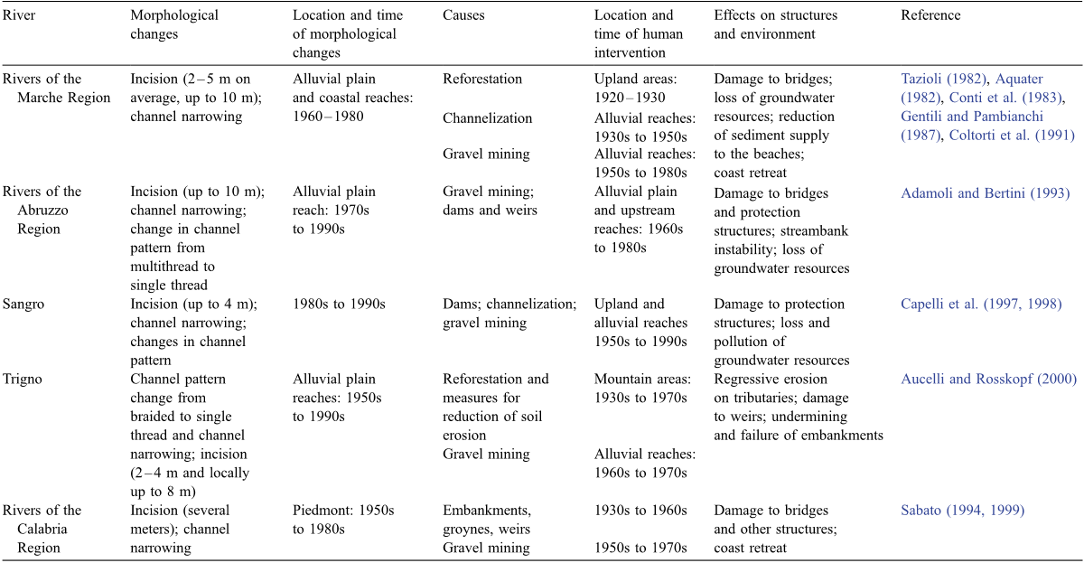
Table 2 Recent channel adjustments in Italian rivers and relative causes and effects 
Fig. 2. Channel incision along the Arno River in the Lower Valdarno–Pisa Plain reach. (A) Example of typical change in cross section, with limited bed lowering from 1936 to 1954, and intense incision from 1954 to 1978. Total bed level lowering from 1844 to 1978 was 6.3 m. (B) Bridge 2 km upstream of the previous section, with exposed piles due to the incision.


Citations
More filters
Recent morphological changes of the River Panaro (Northern Italy)
Abstract: Castaldini D. & Ghinoi A., Recent morphological changes of the River Panaro (Northern Italy) (IT ISSN 0394-3356, 2008). This paper describes the morphological changes of the River Panaro from the 19 h century to date and provides the relationships between human activity and stream geomorphology. The studies were carried out using historical documents and maps, aerial and satellite imagery taken on various dates, digital treatment of maps and orthophotographs and field surveys. The River Panaro has a catchment basin of 1,784 km and collects waters from the central section of the Northern Apennines. It starts from the confluence of the Scoltenna and Leo torrents and flows down through Modena Apennines for some 63 km. It then makes its way across the Po Plain for 85 km until it joins the River Po. In the Po Plain it flows across two distinct sectors with different morphological characteristics: in the upper sector the river runs deep in the alluvial plain, whereas in the mid-lower part it is elevated above the level of the plain, contained within artificial embankments. In the Panaro valley, from the 1930s to the 1950s, the river showed a braided pattern which occupied almost the entire flat valley floor. Important changes occurred later, due to the downcutting and narrowing of the active channel, which have continued until the present day. In the upper part of the plain., the river occupied a large depression with a braided riverbed at the beginning of the 19 century. In the following periods there was an increase of human interventions along the river (construction of embankments, walls and groynes), in order to reclaim surrounding areas from flooding and turn highwater beds into farming land. This led to narrowing in several stretches of the riverbed, although it still maintained a braided pattern until the 1930s. Subsequently, after the 1950s, the braided pattern became canalised and deepened and the shape of the longitudinal profile changed from a hyperbola-type curve to a step-type one. The channel changes in the Apennines and in the upper part of the plain were mainly due to gravel excavation along the riverbed. Quarrying activities stopped after a law was passed in the early 1980s and, at the same time, fluvial barrages were constructed. On the whole, these hydraulic works reduced the bed load, increasing water erosion power downstream. As a result, the deepening process has continued and a new terrace level has formed in the past 30 years. Channel adjustments have led to the change from a braided channel pattern to a transitional one. In the mid-lower part of the plain, the river length has been reduced by 10-11 km (which corresponds to about 13% of its length in this plain sector) by artificial meander cut-offs carried out since the 19 century to reduce flood hazard. In this way, along long stretches of its course, the River Panaro has assumed the aspect of an artificial watercourse. Since the cut-offs did not adequately reduce flood hazard, “flow regulation systems” were constructed in the area east of Modena. It can therefore be stated that the morphology and evolution trend of the River Panaro have been conditioned by direct and indirect human activities over the past two centuries, especially after the 1950s, and that its evolution is similar to what has been recorded in other Italian rivers RIASSUNTO: Castaldini D. & Ghinoi A., Recenti cambiamenti morfologici del Fiume Panaro (Italia settentrionale) (IT ISSN 0394-3356, 2008). Il presente articolo descrive i cambiamenti morfologici del Fiume Panaro a partire dal 19° secolo e illustra le relazioni tra l'attività antropica e la morfologia fluviale. Lo studio è stato realizzato analizzando documenti storici, carte, fotoaeree e immagini satellitari di vari periodi, tramite GIS, ed eseguendo rilevamenti sul terreno. Il F. Panaro, che ha un bacino di 1.784 km, raccoglie le acque dal settore centrale dell'Appennino Settentrionale e le convoglia nel F. Po dopo aver attraversato l'Appennino Modenese, dove nasce dalla confluenza dei torrenti Leo e Scoltenna, per 63 km e la Pianura Padana per 85 km. Nella Pianura Padana il F. Panaro si sviluppa in due settori con diverse caratteristiche morfologiche: nel settore di alta pianura scorre incassato mentre nel settore di media-bassa pianura scorre pensile tra argini artificiali. Nel tratto vallivo, dagli anni '30 agli anni '50 del secolo scorso, il fiume denotava un alveo a canali intrecciati che occupava quasi l'intero fondovalle. Importanti cambiamenti sono intervenuti successivamente in seguito a processi di approfondimento e restringimento dell'alveo che sono continuati sino ad oggi. Nel settore di alta pianura, all'inizio del 19° secolo, il fiume occupava una larga depressione con un tracciato a canali anastomizzati. A partire dalla fine di questo secolo, l'aumento degli interventi antropici lungo il fiume (costruzione di argini, muri e pennelli) realizzati per proteggere il territorio dalle esondazioni ed acquisire terreni per l'agricoltura, ha condotto ad un restringimento dell'alveo sebbene abbia mantenuto un tracciato a canali intrecciati sino agli anni '30. Successivamente agli anni '50 l'alveo si è approfondito e canalizzato; il profilo longitudinale è passato dalla classica curva a forma di iperbole a quella a gradini. I cambiamenti morfologici dell'alveo del F. Panaro sia nel tratto vallivo sia nel tratto di alta pianura sono dovuti principalmente all'attività estrattiva lungo l'alveo, cessata per legge a partire dai primi anni '80, e alla relativa costruzione di briglie. Le briglie hanno ridotto il trasporto solido incrementando in tal modo l'energia della corrente nei tratti a valle di queste strutture. Il risultato è stato che il processo di approfondimento d'alveo è continuato e un nuovo terrazzo si è formato nell'ultima trentina d'anni. L'evoluzione del fiume ha portato ad un cambiamento d'alveo da una morfologia a canali intrecciati ad una transizionale. Nel settore di media e bassa pianura, la lunghezza del fiume è stata ridotta di circa 10-11 km (che corrispondono a circa il 13% del percorso in questo settore) in seguito a tagli di meandri realizzati sin dal 19° secolo per ridurre il pericolo di esondazioni; in questo modo il F. Panaro ha assunto in lunghi tratti l'aspetto di corso d'acqua artificiale. Poiché i tagli di meandro non hanno ridotto tale pericolo, come testimoniato dalle alluvioni verificatesi dopo la loro realizzazione, ad Est di Modena sono state costruite delle casse di espansione. In definitiva si può affermare che la morfologia del F. Panaro e la sua evoluzione sono stati condizionati direttamente ed indirettamente da interventi antropici succedutisi negli ultimi secoli, ed in particolare a partire dagli anni '50, e che la sua evoluzione è simile a quella riscontrata in altri fiumi italiani.
Journal ArticleDOI
Analysis of channel evolution characteristics in the Hobq Desert reach of the Yellow River (1962–2000)
TL;DR: In this paper, the authors used profile data from 80 channel cross-sections obtained in 1962, 1982, 1991 and 2000 from the Yellow River in the Hobq Desert, showing that there was serious sediment deposition here (especially for the tributary section in the eastern desert) and that maximum sediment deposition occurred during 1982-1991.
Journal ArticleDOI
Reactivation of floodplains in river restorations: long-term implications on the mobility of floodplain sediment deposits.
Journal ArticleDOI
Analysis of river lateral channel movement using quantitative geomorphometric indicators: Qara-Sou River, Iran
Fariba Esfandiary,Masoud Rahimi +1 more
TL;DR: In this paper, the authors tried to carefully investigate lateral channel movement of Qara-Sou River during the last 12 years so as to provide a comprehensive understanding of these changes and their calculation methods using GIS techniques.
References
More filters
Journal ArticleDOI
PROFILE: Hungry Water: Effects of Dams and Gravel Mining on River Channels
TL;DR: Management of sand and gravel in rivers must be done on a regional basis, restoring the continuity of sediment transport where possible and encouraging alternatives to river-derived aggregate sources.
OtherDOI
Downstream effects of dams on alluvial rivers.
G.P. Williams,M.G. Wolman +1 more
TL;DR: In this paper, the authors describe changes in mean channel-bed elevation, channel width, bed-material sizes, vegetation, water discharges, and sediment loads downstream from 21 dams constructed on alluvial rivers.
Journal ArticleDOI
A model of channel response in disturbed alluvial channels
TL;DR: In this article, the adjustment of channel geometry and phases of channel evolution are characterized by six process-oriented stages of morphologic development, premodified, constructed, degradation, threshold, aggradation, and restabilization.
Journal ArticleDOI
Riparian vegetation and island formation along the gravel‐bed Fiume Tagliamento, Italy
Angela M. Gurnell,Geoffrey E. Petts,David M. Hannah,Barnaby P.G. Smith,Peter J. Edwards,Johannes Kollmann,James V. Ward,Klement Tockner +7 more
TL;DR: In this paper, a conceptual model of island development is proposed which integrates the interactions between large woody debris and vegetation, geomorphic features, sediment calibre and hydrological regime.
Related Papers (5)
Causes of 20th century channel narrowing in mountain and piedmont rivers of southeastern France
Frédéric Liébault,Hervé Piégay +1 more