3D change detection – Approaches and applications
Reads0
Chats0
TLDR
This paper reviews the recent developments and applications of 3D CD using remote sensing and close-range data, in support of both academia and industry researchers who seek for solutions in detecting and analyzing 3D dynamics of various objects of interest.Abstract:
Due to the unprecedented technology development of sensors, platforms and algorithms for 3D data acquisition and generation, 3D spaceborne, airborne and close-range data, in the form of image based, Light Detection and Ranging (LiDAR) based point clouds, Digital Elevation Models (DEM) and 3D city models, become more accessible than ever before Change detection (CD) or time-series data analysis in 3D has gained great attention due to its capability of providing volumetric dynamics to facilitate more applications and provide more accurate results The state-of-the-art CD reviews aim to provide a comprehensive synthesis and to simplify the taxonomy of the traditional remote sensing CD techniques, which mainly sit within the boundary of 2D image/spectrum analysis, largely ignoring the particularities of 3D aspects of the data The inclusion of 3D data for change detection (termed 3D CD), not only provides a source with different modality for analysis, but also transcends the border of traditional top-view 2D pixel/object-based analysis to highly detailed, oblique view or voxel-based geometric analysis This paper reviews the recent developments and applications of 3D CD using remote sensing and close-range data, in support of both academia and industry researchers who seek for solutions in detecting and analyzing 3D dynamics of various objects of interest We first describe the general considerations of 3D CD problems in different processing stages and identify CD types based on the information used, being the geometric comparison and geometric-spectral analysis We then summarize relevant works and practices in urban, environment, ecology and civil applications, etc Given the broad spectrum of applications and different types of 3D data, we discuss important issues in 3D CD methods Finally, we present concluding remarks in algorithmic aspects of 3D CDread more
Figures

Table 4. Examples of 3D CD applications 
Figure 1. Different geometric comparison methods. (a) Height difference, distances are computed vertically. (b) Euclidean distances, distances are computed in the surface normal direction. (c) projection-based inter-correlation method, the geometric difference is computed by projecting image on to the object, and then back project to image as ; the differences are given by measuring the differences between and . 
Table 3. An overview of the current 3D change detection methods 
Table 5. Recommendations on data co-registration (ordered by priority) 
Table 1. Overview of the differences between 3D and 2D CD problems 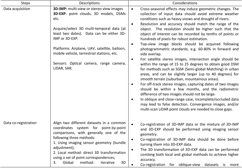
Table 2. Key considerations in a 3D CD task


Citations
More filters
Journal ArticleDOI
A Spatial-Temporal Attention-Based Method and a New Dataset for Remote Sensing Image Change Detection
Hao Chen,Zhenwei Shi +1 more
TL;DR: This work proposes a novel Siamese-based spatial–temporal attention neural network, which improves the F1-score of the baseline model from 83.9 to 87.3 with acceptable computational overhead and introduces a CD dataset LEVIR-CD, which is two orders of magnitude larger than other public datasets of this field.
High-Resolution Monitoring of Himalayan Glacier Dynamics Using Unmanned Aerial Vehicles
Walter W. Immerzeel,Philip Kraaijenbrink,Joseph M. Shea,Arun Bhakta Shrestha,Francesca Pellicciotti,Francesca Pellicciotti,Marc F. P. Bierkens,S.M. de Jong +7 more
TL;DR: In this article, a UAV was deployed over the debris-covered tongue of the Lirung Glacier in Nepal and the mass loss and surface velocity of the glacier were derived based on ortho-mosaics and digital elevation models.
Journal ArticleDOI
Unmanned Aerial Vehicle for Remote Sensing Applications—A Review
TL;DR: This paper performs a critical review on RS tasks that involve UAV data and their derived products as their main sources including raw perspective images, digital surface models, and orthophotos and focuses on solutions that address the “new” aspects of the U drone data including ultra-high resolution; availability of coherent geometric and spectral data; and capability of simultaneously using multi-sensor data for fusion.
Journal ArticleDOI
Change Detection Based on Artificial Intelligence: State-of-the-Art and Challenges
Wenzhong Shi,Min Zhang,Min Zhang,Rui Zhang,Shanxiong Chen,Shanxiong Chen,Zhao Zhan,Zhao Zhan +7 more
TL;DR: This review focuses on the state-of-the-art methods, applications, and challenges of AI for change detection, and the commonly used networks in AI forchange detection are described.
Journal ArticleDOI
Linking Points With Labels in 3D: A Review of Point Cloud Semantic Segmentation
TL;DR: In this article, the authors summarized available data sets and relevant studies on recent developments in point cloud semantic segmentation and point cloud segmentation (PCS) for 3D point clouds.
References
More filters
Journal ArticleDOI
UAV Photogrammetry Application to the Monitoring of Rubble Mound Breakwaters
TL;DR: The UAV photogrammetry system provides the exact position where the movement of the cube is produced and can be easily integrated with geographic information systems to monitor movement of cubes in breakwaters.
Proceedings ArticleDOI
A multi-cameras 3D volumetric method for outdoor scenes: a road traffic monitoring application
J. Douret,Ryad Benosman +1 more
TL;DR: The aim is to remove the classic monocular ambiguities and to retrieve the objects height and an efficient and simple calibration method is presented, based on an altitude planar decomposition of the road scene.
Journal ArticleDOI
Improving Change Detection in Forest Areas Based on Stereo Panchromatic Imagery Using Kernel MNF
TL;DR: It is shown that with the same amount of training samples, the proposed method can obtain more accurate change masks compared with algorithms based on k-means, one-class support vector machine, and random forests.
Automated Change Detection for Validation and Update of Geodata
TL;DR: In this article, an automatic change detection method considering changes in the building theme and based on colourinfrared (CIR) aerial photographs in combination with height information (LIDAR, digital photogrammetry) is presented.
Development of a continuous 3D-monitoring system for unstable slopes using Time Domain Reflectometry
J. Singer,Kurosch Thuro +1 more
TL;DR: In this paper, a cable is installed in a borehole and coupled to the surrounding rock with grout, and an electric pulse with an ultra-fast rise is applied to the cable and a reflection is detected.