scispace - formally typeset
Open AccessJournal ArticleDOI

Parsimonious hydrological modeling of urban sewer and river catchments

Reads0
Chats0
TLDR
In this paper, a parsimonious model of flow capable of simulating flow in natural/engineered catchments and at WWTP (Wastewater Treatment Plant) inlets was developed.
About
This article is published in Journal of Hydrology.The article was published on 2012-09-25 and is currently open access. It has received 36 citations till now. The article focuses on the topics: Impervious surface & Combined sewer.

read more

Citations
More filters
Journal ArticleDOI

Hydrograph modeling with rational modified method

TL;DR: In this paper, a modified rational method (MRM) base on its equation modification was used to calculate peak discharge and unit hydrograph. But the accuracy of the model was not very good, i.e. 10-30 %.
Book ChapterDOI

Urban Hydrology in a Changing World

TL;DR: In this paper, the authors review some of the challenges that hydrologists face in managing and modelling urban hydrological systems under changing environmental conditions, such as urbanization and climate change.
Journal ArticleDOI

Analysis and evaluation of a sewage network during heavy rains using the SSOAP toolbox

Abstract: One of the major problems facing urban areas is the recent increase in precipitation intensity over design standards due to global warming. This significantly increased precipitation depth directly influences sewage systems by causing increased flow and infiltration (RDII), which eventually leads to flooding of the systems. The aim of this study was to analyse and evaluate a sewage network during such severe rainfall, to determine the excess amount of rain entering the system. To achieve this, the Hay Al-Hurr region of Karbala was selected as a case study, and the Sanitary Sewer Overflow Analysis and Planning (SSOAP) toolbox was used to estimate the volumes of inflow and infiltration (RDII) entering the sewer network, while the stormwater management software (SWMM5) within the toolbox was used for hydraulic assessment of the sewage system. The sewage network of the main pipeline of the study area was analysed with regard to two rain events in 2016, one of which was a standard event of 25 mm, and the other a torrential event of 105 mm. The RDII was 2.29 mm for the first event and 2.58 mm for the second event; on calibrating these results with SWMM5, a display of flood areas for each event was created showing the percentage overflows for two events were 30% and 65%, respectively. These results were realistic and according to predictions, allowing the study to help improve engineering knowledge and decision-making capabilities with regard to designing sewage networks, as well as facilitating the development of appropriate solutions to rehabilitate those areas most vulnerable to standardised entry by developing specific strategies to reduce or eliminate the surplus runoff.
Dissertation

Water Sensitive Urban Design (WSUD) Strategies to Mitigate the Impacts of Intense Rainfall on the Sanitary Sewer Network Performance

Tasnim Nasrin
TL;DR: In this paper, a generalised framework for assessing and mitigating the impacts of intense rainfall on the performance of the sanitary sewer network is developed, where two commonly used Water Sensitive Urban Design (WSUD) approaches, namely rainwater tanks and rain gardens, are used to mitigate the negative impacts of rainfall induced SSO.

Spatial extent and ecotoxicological risk assessment of a micropollutant-contaminated wastewater plume in Lake Geneva

C Corinne
TL;DR: In this article, the spatial extent of a wastewater- influenced water mass (plume) originating from a waste- water treatment plant outlet in Vidy Bay ( Lake Geneva) was monitored by two manned submersibles from June to August 2011.
References
More filters
Book

Crop evapotranspiration : guidelines for computing crop water requirements

TL;DR: In this paper, an updated procedure for calculating reference and crop evapotranspiration from meteorological data and crop coefficients is presented, based on the FAO Penman-Monteith method.
Journal ArticleDOI

River flow forecasting through conceptual models part I — A discussion of principles☆

TL;DR: In this article, the principles governing the application of the conceptual model technique to river flow forecasting are discussed and the necessity for a systematic approach to the development and testing of the model is explained and some preliminary ideas suggested.

A physically based, variable contributing area model of basin hydrology

Mike Kirkby, +1 more
TL;DR: In this paper, a hydrological forecasting model is presented that attempts to combine the important distributed effects of channel network topology and dynamic contributing areas with the advantages of simple lumped parameter basin models.
Journal ArticleDOI

A physically based, variable contributing area model of basin hydrology / Un modèle à base physique de zone d'appel variable de l'hydrologie du bassin versant

TL;DR: In this paper, a hydrological forecasting model is presented that combines the important distributed effects of channel network topology and dynamic contributing areas with the advantages of simple luminescence.
Journal Article

Washington DC - USA

Related Papers (5)
Frequently Asked Questions (11)
Q1. What are the main physical processes driving the discharge at the two basin end-points in this?

The dominant physical processes driving water discharge at the two basin end-points in this study are Hortonian runoff, evapotranspiration, and gravity-driven percolation to groundwater. 

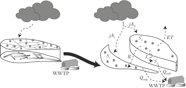
Two important modeling assumptions are: (i) the pipe network is replaced by an underground impervious area and thus overland flow and pipe discharge can be together modeled as a fast discharge linear reservoir, and (ii) the water diverted out of the sewer system through the different CSOs can be combined together through the hydraulic discharge function of a representative CSO. 

Most popular urban hydrological models used in research and engineering (e.g., MOUSE (Hernebring et al., 2002), SWMM3) are spatially distributed with link-node drainage networks. 

In this study, a hierarchical physically based storage and transmission model was designed as an alternative means for simulating continuous flow dynamics in complex engineered urban basins. 

In addition, the hydrological model integrates functions that aim to reproduce characteristic daily variations of dry weather flow to the WWTP. 

Detailed modeling of drainage systems is often deemed necessary because of the complexity of flow paths in urban catchments (Cantone and Schmid, 2011; Gironás et al., 2009). 

The type of precipitation is determined based on a temperature threshold (DeWalle and Rango, 2008; Schaefli et al., 2005): when T is above the threshold Tcr , precipitation occurs as rain, otherwise precipitation is frozen. 

This CSO, the closest CSO to the WWTP, is responsible for more than a third of all CSO discharge, and is typically the first to become operational in storms (e-dric.ch, 2008). 

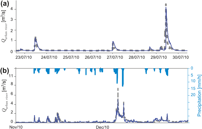
During dry weather, discharges arriving at the WWTP inlet are determined mainly by two phenomena: (i) infiltration of groundwater into the pipe network (see Section 2.2 and Dupont et al. (2006); Göbel et al. (2004)) and, (ii) water use and consequent wastewater production. 

It is a typical urban catchment, where much water comes from toilets, washing, industry and other uses, rather than directly from natural sources. 

Saturation excess was not implemented in their modeling scheme as the authors considered an unlimited reservoir height – i.e., the reservoir is never full – and this could lead to underestimation of surface runoff (Buda et al., 2009; MartínezMena et al., 1998; Nachabe et al., 1997).