HAL Id: hal-00561576
https://hal.archives-ouvertes.fr/hal-00561576
Submitted on 2 Feb 2011
HAL is a multi-disciplinary open access
archive for the deposit and dissemination of sci-
entic research documents, whether they are pub-
lished or not. The documents may come from
teaching and research institutions in France or
abroad, or from public or private research centers.
L’archive ouverte pluridisciplinaire HAL, est
destinée au dépôt et à la diusion de documents
scientiques de niveau recherche, publiés ou non,
émanant des établissements d’enseignement et de
recherche français ou étrangers, des laboratoires
publics ou privés.
Contrasted evolution of glacial lakes along the Hindu
Kush Himalaya mountain range between 1990 and 2009
Julie Gardelle, Y. Arnaud, Etienne Berthier
To cite this version:
Julie Gardelle, Y. Arnaud, Etienne Berthier. Contrasted evolution of glacial lakes along the Hindu
Kush Himalaya mountain range between 1990 and 2009. Global and Planetary Change, Elsevier, 2011,
75 (1-2), pp.47-55. �10.1016/j.gloplacha.2010.10.003�. �hal-00561576�

Contrasted evolution of glacial lakes along the Hindu Kush Himalaya mountain range
between 1990 and 2009.
Julie Gardelle
a*
, Yves Arnaud
a,b
, Etienne Berthier
c
*Corresponding author: julie.gardelle@lgge.obs.ujf-grenoble.fr. Tel.: +33 4 76 82 42 06.
a
Laboratoire de Glaciologie et Géophysique de l’Environnement, CNRS, UJF-Grenoble, 54 rue Molière, BP
96, 38402 Saint Martin d’Hères, France.
b
Laboratoire d’études des Transferts en Hydrologie et Environnement, IRD, 1023 rue de la Piscine, BP 53,
38401 Grenoble Cedex 09, France.
c
CNRS; Université de Toulouse ; LEGOS; 14 Av. Ed. Belin, 31400 Toulouse, France
Citation: Julie Gardelle, Yves Arnaud, Etienne Berthier, Contrasted evolution of glacial lakes along the Hindu Kush
Himalaya mountain range between 1990 and 2009, Global and Planetary Change, Volume 75, Issues 1-2, January
2011, Pages 47-55, DOI: 10.1016/j.gloplacha.2010.10.003
Abstract
In this study, we present a first regional assessment of glacial lake distribution and evolution in the Hindu
Kush Himalaya (HKH). Seven sites have been selected between Bhutan and Afghanistan, to capture the
climatic variability along the 2000-km long mountain range. For each site, glacial lakes have been mapped
with LANDSAT satellite imagery acquired in 1990, 2000 and 2009, using an automatic classification. In the
East (India, Nepal and Bhutan), glacial lakes are bigger and more numerous than in the West (Pakistan,
Afghanistan), and have grown continuously between 1990 and 2009 by 20% to 65%. On the other hand,
during the same period, the glacial lake coverage has shrunk in the Hindu Kush (-50%) and the Karakorum (-
30%). This east/west pattern of lake changes seems in agreement with sparse glaciological measurements
that suggest less (or even no) ice loss in the western part of the HKH.
Keywords: Glacial lakes, Himalaya, Remote sensing
1. Introduction
Little is currently known about the distribution and evolution of glacial lakes in the vast Hindu Kush
Himalaya (HKH) mountain range although those lakes are potentially an indirect indicator of glacier change
and, in certain cases, threaten the life of the inhabitants of the mountain valleys (Richardson and Reynolds,
2000).
Two types of glacial lakes can be distinguished: (i) pro-glacial lakes, often growing downstream of steep
glaciers, where water is collected behind former moraines (Richardson and Reynolds, 2000; Komori, 2008);
(ii) supra-glacial lakes, which develop on the surface of the glacier itself, growing by coalescence of small
ponds. They tend to develop on long, flat, debris-covered valley glaciers which respond to a negative mass
balance by thinning (downwasting) rather than by a terminus retreat (Reynolds, 2000; Richardson and
Reynolds, 2000; Quincey et al., 2007; Komori, 2008).
Recent expansion of glacial lakes in the Himalaya has mainly been studied in north Bhutan (Fujita et al.,
2008; Komori, 2008) and in the Everest region (Yamada and Sharma, 1993; Sakai et al., 2000; Benn et al.,
2001; Wessels et al., 2002; Bolch et al., 2008a). However, the distribution and the temporal evolution of
glacial lakes over the entire HKH range have never been addressed yet. As suggested by Kargel et al. (2005),
glacier and glacial lake evolution are likely to be very different between the eastern part of the mountain
range where the large majority of glaciers are retreating and the western part where glacier changes are
slower. The purpose of this paper is thus to give an overview of the distribution and recent evolution of

glacial lakes along the HKH range, from Bhutan to Afghanistan. To achieve this goal, a set of optical
satellite images has been used, with a time coverage spreading from 1989 to 2009.
2. Study area and data
2.1. Study area
The HKH region, ranging from Afghanistan to Bhutan, is covered by about 60,000 km² of glaciers
(Dyurgerov and Meier, 2005). Precipitation regimes are driven by the Indian monsoon in summer
(precipitation occurring from June to September) and by the mid-latitude westerlies in winter (precipitation
occurring from January to April) (Böhner, 2006). The precipitation pattern is characterized by two gradients
(Bookhagen and Burbank, 2006): (i) a north-south gradient due to the orographic barrier, preventing air
masses to go further north, (ii) an east-west gradient, due to the weakening westwards of the Indian monsoon
coming from the Bay of Bengal, and implying a greater humidity in the eastern HKH.
Figure 1: Location of the seven study sites along the HKH range (their names appear in bold on the map). For each
site, the footprint of a LANDSAT image is shown. Ice covered areas are represented by blue filled polygons.
In order to study glacial lakes over the HKH region, seven study sites (comprising a high proportion of
glaciarized area) have been selected along the mountain range, so as to be representative of the climatic
gradients (Table 1). Their locations are presented in Figure 1. Their extent corresponds to the footprint of a
LANDSAT image, i.e. 31110 km². These seven study sites encompass approximatively 24100 km
2
of
glaciers, or 40% of the total ice-covered area in the HKH (Table 2). Bhutan, Everest and West Nepal sites
are directly influenced by the Indian monsoon, summer being both ablation and accumulation seasons on
glaciers (Fujita, 2008). Western sites, namely Hindu Kush and Karakorum, are much dryer, with
precipitation occurring mainly during winter. Between these two extreme parts of the HKH region, the Spiti
Lahaul and Garhwal sites represent a transition zone, influenced by both the summer monsoon and the winter
westerlies (Figure 2).

Mean annual temperature (°C)
Site name
at 600hPa
at mean glacial lake altitude
Mean annual
precipitation (m)
Bhutan
-0.2
-3.7
1.03
Everest
-0.2
-5.5
1.04
West Nepal
-1.2
-6.9
0.91
Garhwal
-1.7
-4.5
0.87
Spiti Lahaul
-2.4
-2.5
0.86
Karakorum
-3.7
-3.3
0.30
Hindu-Kush
-4.5
-0.8
0.35
Table 1: Climate characteristics of the seven study sites (temperatures at 600hPa and interpolated between two
pressure levels at the mean lake altitude from NCEP/DOE-Reanalysis 2, precipitation from Global Precipitation
Climatology Project).
Site name
Glacier
area (km²)
Glacier mean
altitude (m)
Front mean
altitude (m)
Lake mean
altitude (m)
Number
of lakes
Total lake
area (km²)
Bhutan
1510
5600
4836
4814
203
27.2
Everest
2919
5614
5084
5079
583
29.1
West Nepal
960
5431
5128
5117
116
16.6
Garhwal
3910
5337
4278
4683
233
2.2
Spiti Lahaul
2854
5091
4129
4209
35
1.9
Karakorum
8718
5153
3609
4129
422
3.7
Hindu-Kush
3229
4617
3206
3622
102
0.7
Table 2: Glaciers and lakes characteristics of the seven study sites. A LANDSAT scene covers in total ~31110 km², but
on each site, only the part of the scene covered with glaciers has been analyzed.
Figure 2: Monthly precipitations from Global Precipitation Climatology Project for three study sites: Everest, Garhwal
and Hindu Kush.
2.2. Data
To avoid cloud cover during the monsoon and ensure minimal snow coverage, we selected satellite images
acquired between September and November (for the eastern part) and between June and October (for the
western part). Each of the seven study sites has been observed with two LANDSAT-TM and a LANDSAT-
ETM image with a spatial resolution of 30 m (images downloaded from http://glcf.umiacs.umd.edu and

http://glovis.usgs.gov). The images were already radiometrically corrected and projected in the UTM
coordinate system. Acquisition dates are listed in Table 3.
Site name
LANDSAT
TM
ETM
TM
Bhutan
14/11/1990
04/11/2001
17/10/2009
Everest
17/11/1992
30/10/2000
31/10/2009
West Nepal
21/10/1992
03/10/2000
18/09/2009
Garhwal
15/11/1990
15/10/1999
12/06/2009
Spiti Lahaul
09/10/1989
15/10/2000
01/11/2009
Karakorum
29/06/1990
12/10/2002
21/09/2009
Hindu-Kush
26/07/1989
16/09/1999
19/09/2009
Table 3: Dates (format is DD/MM/YYYY) of the images used in this study.
For each study site, a digital elevation model (DEM) of 2000 from the SRTM (Shuttle Radar Topography
Mission) has also been downloaded at http://srtm.csi.cgiar.org/, with a spatial resolution of 90 m.
Glacier inventories have been obtained from the GLIMS (Global Land Ice Measurements from Space, Raup
et al., 2007) and ICIMOD (International Center for Integrated Mountain Development, ICIMOD, 2007)
databases, which provide glacier outlines associated with various attributes, such as glacier length, area and
orientation.
Finally, to analyze climate variability along the HKH, monthly air temperatures at 600 hPa and at the lake
altitude were extracted from NCEP/DOE (National Centers for Environmental Prediction/Department of
Energy) reanalysis-2 data on a 2.5°x2.5° grid (Kanamitsu et al., 2002) since 1979. Temperatures at 600 hPa
are used as an indicator of the overall trend in temperatures along the HKH range, whereas temperatures at
mean glacial lake altitude are used to interpret glacial lake evolution. The latter are computed by
interpolating temperature data between two pressure levels enclosing the mean glacial lake altitude.
Precipitations have been analyzed through the Global Precipitation Climatology Project, providing monthly
values on a 2.5°x2.5° grid since 1979 (GPCP, Huffman and Bolvin, 2009). Time series of monthly
temperature and precipitation in the middle of each study site during each decade since 1979 were computed
using a bilinear interpolation, based on the four surrounding grid points.
3. Methodology
Others authors previously addressed the question of mapping glacier lakes from multispectral satellite
imagery. Wessels et al. (2002) performed a spectral analysis of terrain features in the Mount Everest region
based on ASTER imagery, outlining the importance of water turbidity when monitoring glacial lakes. A
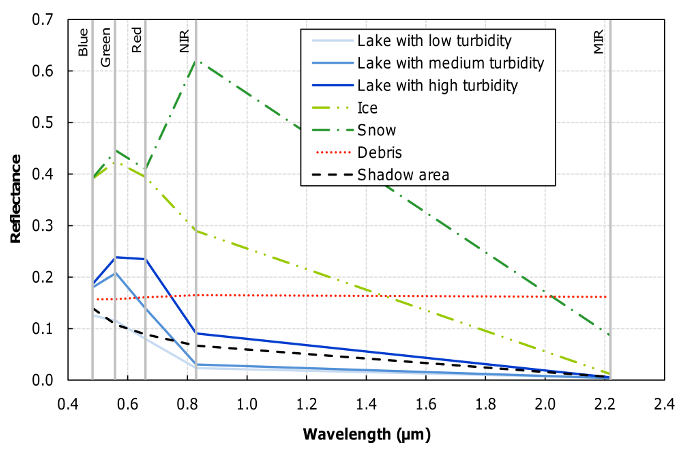
similar spectral analysis has been carried out with one of our LANDSAT scene (Figure 3). The more turbid a
glacial lake is, the higher its reflectance in the Visible and Near Infra-Red (VNIR) is, mainly because of the
high suspended sediment load. As we are considering optical images, shadowing is problematic, especially in
mountainous area when the solar zenith angle is high. It is important to notice that the spectral signature of
these shadow areas (black line in Figure 3) is very similar to the one of glacial lakes with low turbidity.
Wessels et al. (2002) also discussed the automatic classification of glacial lakes. Using the four bands in the
VNIR and MIR (Middle Infra-Red) of ASTER data, they computed two ratios to distinguish (i) water
surfaces from non-water surfaces, with ratio R
1
(Equation 1) (ii) solid (ice or snow) from liquid (free water)
surface, among classified water surfaces, with ratio R
2
(Equation 2).
(1)


